Contact us
Get in touch with our experts to find out the possibilities daily truth data holds for your organization.

For decades, the insurance industry has been waiting for the skies to clear after a hurricane. Claims teams were stuck relying on flyovers, manual reports, or model-based estimates, all arriving too late to accelerate response.
That delay isn’t just a frustration. It drives up operating costs, prolongs settlements, and leaves policyholders in the dark when they need answers most.
At ICEYE, we set out to solve this problem at the source. Powered by the world’s largest synthetic aperture radar (SAR) satellite constellation, our new Hurricane Solution offers near real-time, multi-peril observations across the entire footprint of the storm.
Below, we answer nine of the most common questions we hear from claims, risk, and cat modeling teams exploring how this fits into their hurricane response strategy.
Here’s what we will cover.
Let’s start with the basics.
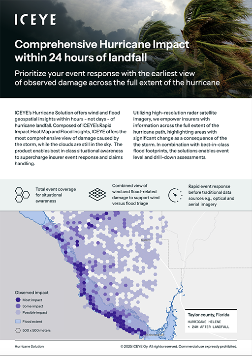
The Hurricane Solution is composed of two geospatial data products.
These layers offer a comprehensive, multi-peril view, helping insurers understand the impacts of wind and water at speed and scale.

For qualifying hurricanes, ICEYE delivers the first release within 24 hours of landfall, with subsequent updates every 24 hours as more data becomes available. Each release expands coverage, supporting insurers in moving from rough estimates to precise response while the event is still active.
In most cases, this means insurers can identify large losses and initiate triage while skies are still overcast, gaining a multi-day head start on claims and resource decisions.
We understand every company has different systems and workflows, so we offer multiple access points:

Our Solutions and Customer Success teams are available to help configure the best option for your needs.
ICEYE’s Hurricane Solution is available for Category 1 or stronger hurricanes that impact the United States or its territories.
Coverage typically includes:
Our pre-imaging strategy means the radar constellation is already watching high-risk areas before storms hit, ensuring we can move fast when activation thresholds are met.

Yes, and that’s the game-changer. ICEYE’s Hurricane Solution enables you to triage claims more accurately from the start. This means that you could:
This isn’t a replacement for adjusters—it’s the intelligence layer that ensures you send the right resources to the right places.
Granular enough to see building-level changes, but flexible enough to scale up for portfolio-wide assessments.
The end result is a scalable data foundation that works whether you're analyzing a ZIP code or a whole region.
While many systems rely on forecast-based models or proxy data, ICEYE delivers observations—measured information captured before and after the event to help users understand what actually happened. It can be used as a reliable data point for benchmarking other estimates, e.g., pre-event models.
We’re not just giving you images or models but delivering observed geospatial data that plugs directly into your workflows, from event response to reporting.
Timeliness is one thing, and scale is another.
Aerial imagery is often delayed by days due to weather and airspace restrictions. Even when it becomes available, the coverage is usually limited to specific zones, often selected based on assumptions or prior exposure maps. That means early flights can miss entire areas of heavy loss.
With ICEYE’s synthetic aperture radar (SAR) constellation, satellites can image the storm footprint through cloud cover, darkness, and smoke, capturing thousands of square miles at once. We cover entire hurricane swaths—up to 100 miles inland—delivering the clarity you need, exactly when you need it.
The value of ICEYE’s Hurricane Solution isn’t just in how fast it arrives, it’s in how much insurers can do with it. Within a few hours of landfall, our customers receive impact data granular enough to make material decisions across the full extent of the storm.
ICEYE’s radar satellites collect data regardless of cloud cover or time of day, which means the data keeps flowing while other sources are grounded.
Insurers applying the solution during live events have used it to:

Would you like to know more?
Book a demo with our Solutions Team to see the ICEYE Hurricane Solution in action before the next storm hits. We’ll show you how the product works, how you could integrate it with your portfolio, and how it can make your next hurricane response smarter, faster, and more confident.
Hurricane Solution Info Pack for Insurers

14 May 2026

18 March 2026

11 December 2025


