Contact us
Get in touch with our experts to find out the possibilities daily truth data holds for your organization.
The session was packed with sharp questions from the audience, real-life event examples from ICEYE, and honest conversations about how satellite-powered observations work when traditional tools fail.
The biggest revelation for many in the room: synthetic-aperture radar (SAR) isn't trying to take pictures. It’s providing actionable data. As Stephen Lathrope put it:
This is an active signal that we send, we receive, we can interpret, and we can do that whatever the weather, wherever we're passing."
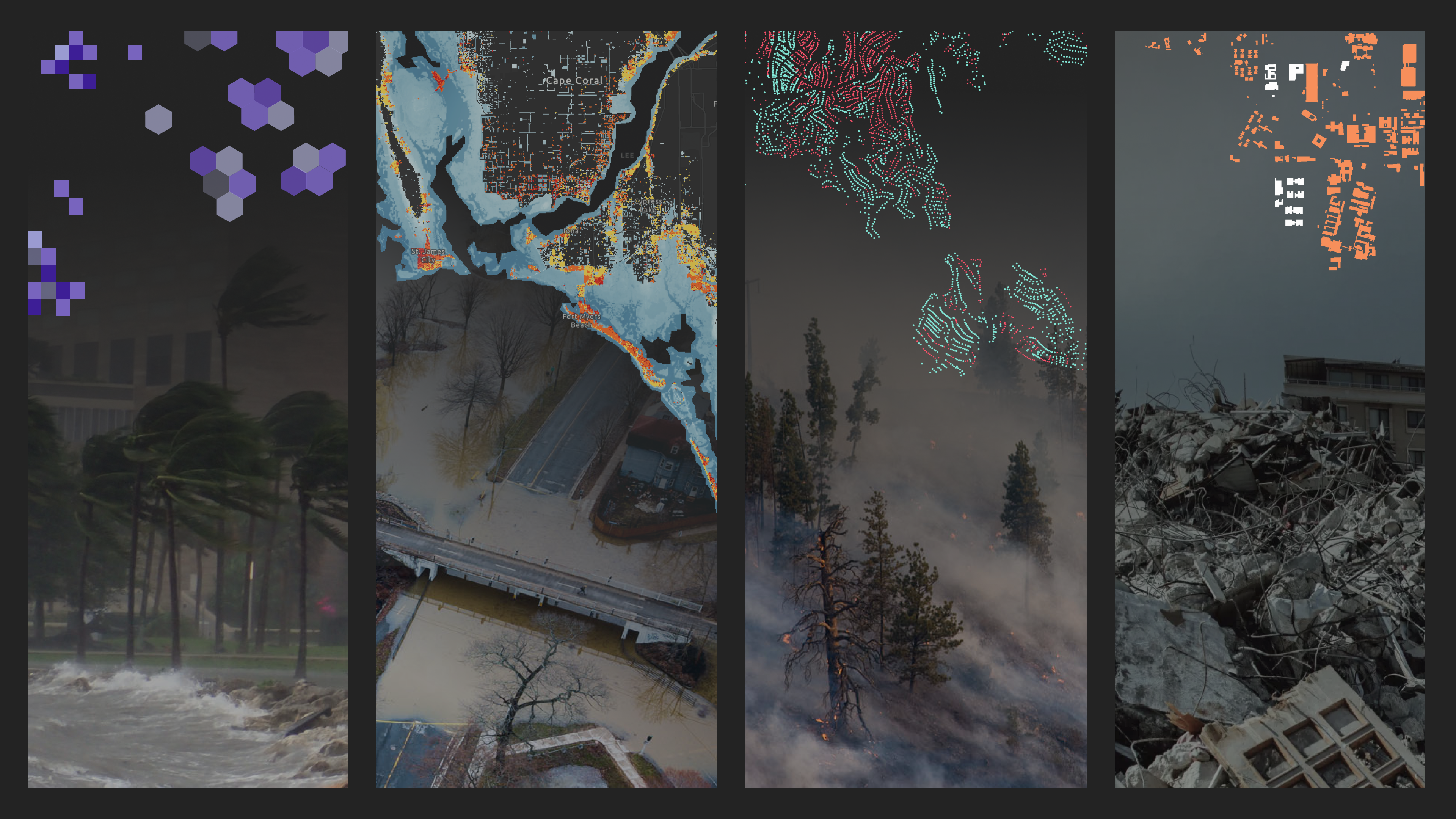
ICEYE operates 50+ SAR satellites that work day or night, through clouds, smoke, rain, and darkness. While optical satellites and aerial surveys wait for clear conditions, SAR keeps collecting actionable intelligence and detecting changes on the ground across hundreds of square kilometers. The process is straightforward: capture baseline images before events hit, task satellites as threats develop, then turn raw data into layers your teams can use immediately.

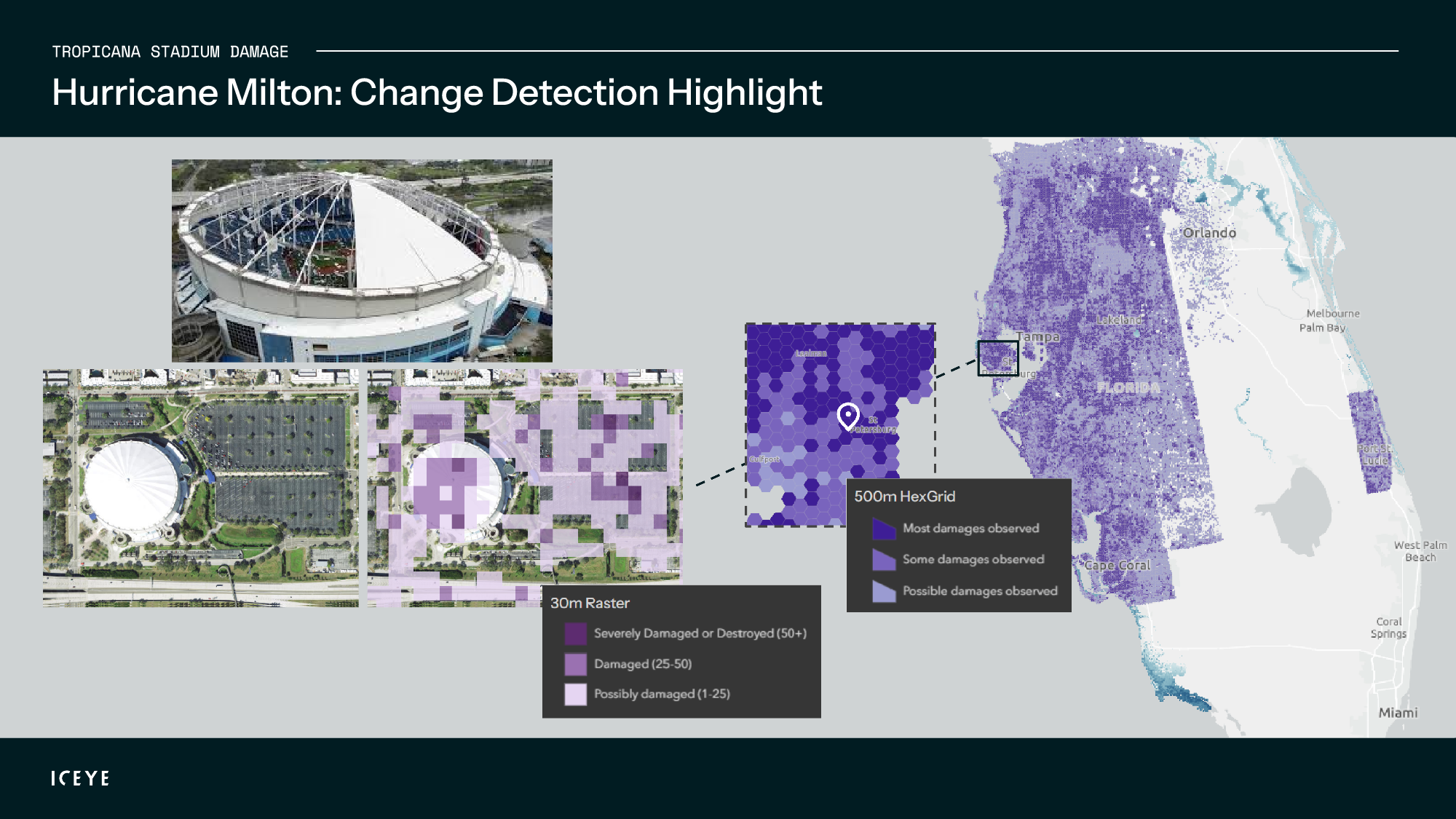
The most practical discussion centered on hurricanes and how to quickly separate wind damage from water damage. When someone asked how ICEYE measures change between before-and-after images, Stephen clarified:"We're not trying to quantify it... We're purely about the data because we deliver this data from our analysis, and we give it to people for different purposes."
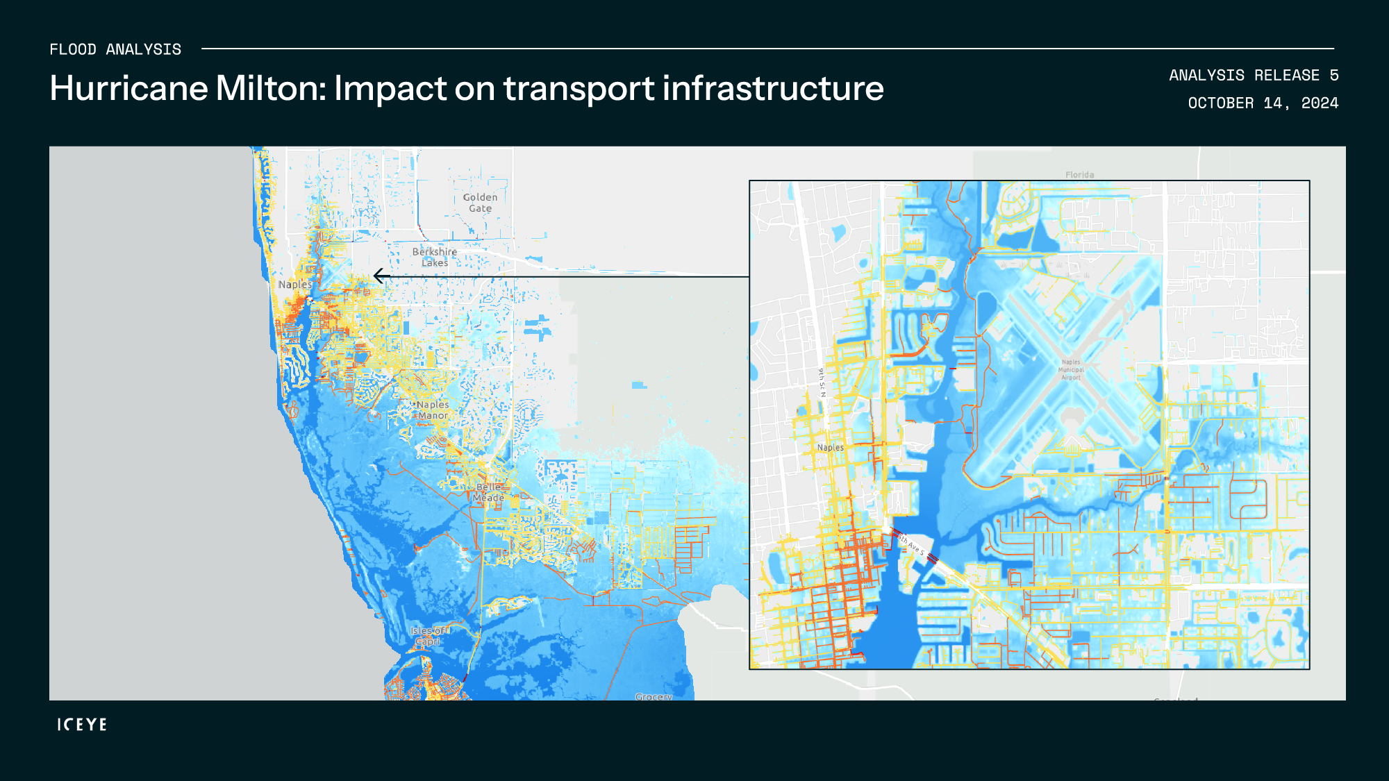
ICEYE's Hurricane Solution combines damage heat maps with flood intelligence to tackle the wind versus flood triage challenge that every carrier faces. Within 24 hours of landfall, our customers get neighborhood-level damage indicators plus building-specific flood depth data. Updates arrive every 24 hours as conditions evolve.
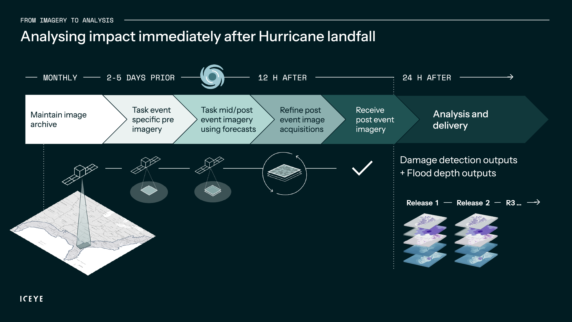
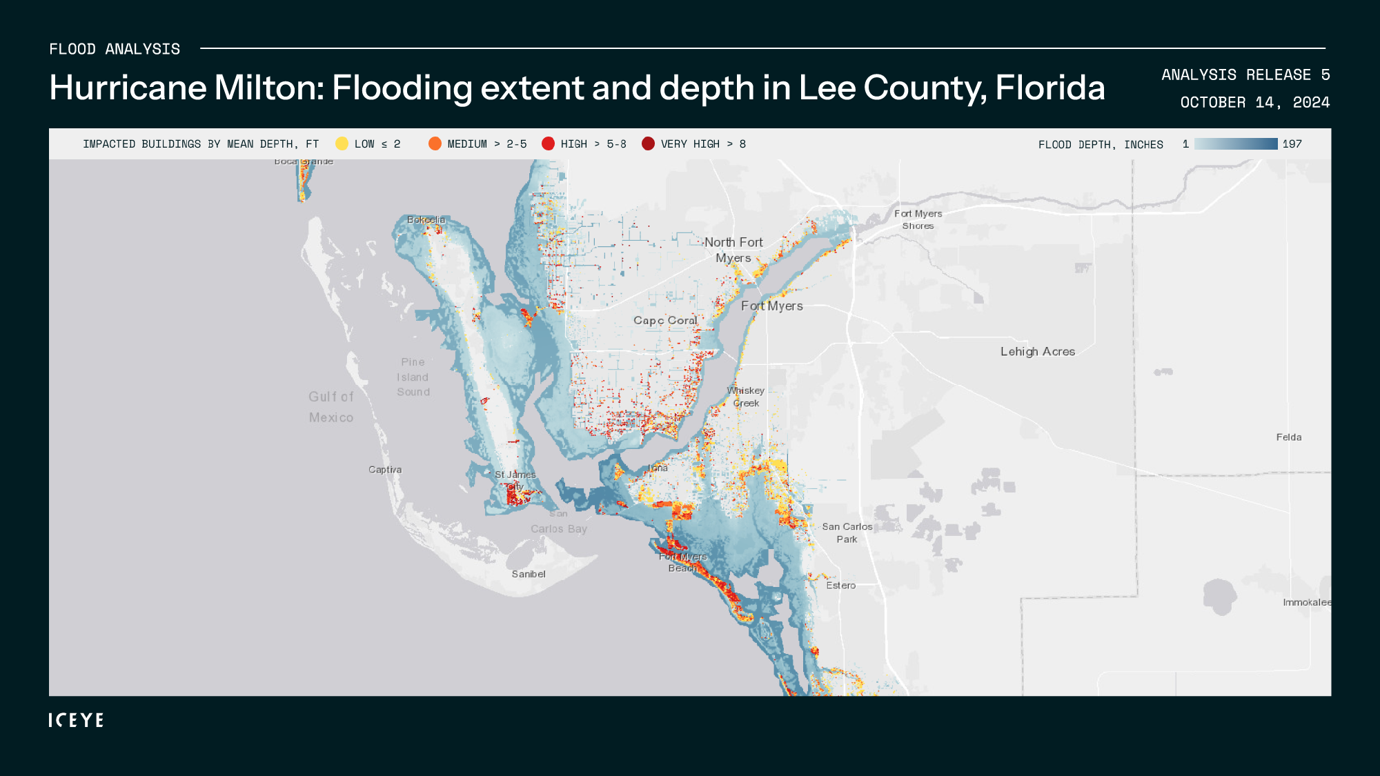
Timing matters for efficient operations. Stephen noted that ICEYE’s flood extent arrives in 6 to 8 hours because it's automated. Depth calculations take slightly longer. Usually, the first release is 24 hours after landfall, and then we update it every 24 hours because the system fuses water observations with terrain models.
This cadence enables practical wind vs. flood triage: our customers can route wind-only losses to general adjusters, prioritize complex flood claims for specialists, and deploy housing and vendor resources where depth data shows the greatest impact.
What struck the audience was the consistency across different catastrophe types. Rather than juggling separate vendors and data formats, ICEYE delivers observation-based intelligence for hurricanes, floods, wildfires, and earthquakes through the same satellite constellation and processing pipeline, embracing a full multi-peril approach.
For floods specifically, the system provides predictive insights up to 96 hours ahead, then tracks events dynamically and delivers observed extent and depth within roughly 24 hours of peak conditions. The advantage is consistency—whether you're dealing with hurricane-driven storm surge or inland river flooding, the data format and delivery timeline remain similar.

When it comes to wildfire data, ICEYE provides event lifecycle data and live fire monitoring, with a list of destroyed buildings produced every 24 hours through fire duration. Our Building Damage Assessment layer (in vector file format) includes latitude and longitude points with a binary classification of damage (0 = likely not destroyed / undamaged; 1 = likely destroyed) for each structure location within the analyzed fire perimeter.
That clarity pays off operationally. While smoke grounds aircraft and obscures optical sensors, our Wildfire Insights continues delivering building-level assessments every 24 hours throughout the fire's duration. Each structure gets a simple classification (destroyed or not destroyed), which makes our output clean, actionable, and fast for our customers.
The earthquake piece was brand new to the Monte Carlo RVS audience. Stephen walked everybody through a Japanese event where "fire had followed the earthquake damage", a reminder that catastrophes rarely arrive solo.
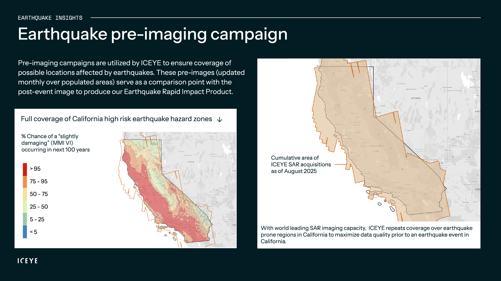
ICEYE's earthquake workflow starts with continuous pre-imaging across high-risk regions like California. When shaking occurs, rapid change detection maps are created where structural damage is most likely across the full footprint. Since SAR penetrates smoke, the same approach tracks fire following when the airspace gets restricted.
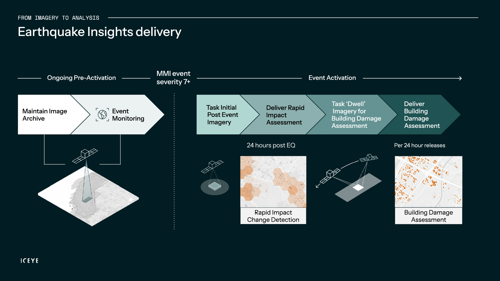
By combining earthquake-triggered change detection with high-resolution, targeted fire damage detection, insurers and reinsurers can access an enhanced view of structure impact. This supports faster claims processing, improved loss validation, and more informed event impact sizing in the wake of complex, multi-hazard events.
As Rupert Bidwell summarized the operational shift: "It allows you to pivot from a forecast view of an event to an observed - what actually happened view of the event."
Much of the discussion in Monte Carlo centered on practical implementation. How is it priced? Through transparent subscriptions based on gross written premium and use cases, supported by an online calculator for easy planning. What about coverage? Each image spans up to 100 km × 100 km, adjustable for higher-resolution focus on specific areas.
What ultimately resonated with the audience was the scale and immediacy of the capability. In a post-catastrophe environment where every hour counts, ICEYE’s ability to analyze 11,500 square miles within 24 hours for Hurricane Helene, and over 10,000 for Milton, illustrated how observation-based data can fundamentally reshape catastrophe operations.
The questions from insurers and reinsurers were consistent: Does it help them triage more effectively? Can they contact customers sooner? Will their stakeholders trust the data? Based on the case examples and live demonstrations, the answer appeared clear. Claims teams can identify major losses early and reach policyholders before claims are even filed. Exposure managers can quantify affected policies across grids and ZIP codes, even with incomplete exposure data. Reinsurance teams gain time-stamped, independently verified evidence to support cash calls and coverage validation.
As Stephen Lathrope noted during the session, “We’re not qualified to do the sums.” ICEYE’s role is to deliver consistent, objective observations—empowering insurers to make faster, better-informed decisions for their customers, portfolios, and partners.
Ready to see how it works?
Watch the full workshop: The complete Monte Carlo session with Stephen Lathrope and Rupert Bidwell is now available on YouTube via this link below.
.png?width=950&height=534&name=YT%20Thumbnail%20-%20MCRV%20(2).png)

14 May 2026

18 March 2026

11 December 2025