Wildfire_public-sector-response_hero_medium Wildfire_public-sector-response_hero_medium_mobile

ICEYE Wildfire Insights

Strengthen wildfire resilience with automated monitoring & damage assessments

Leverage the world's largest constellation of smoke-penetrating SAR satellites to support rapid wildfire response, recovery, and mitigation at the community level.

Assess wildfire impacts before the smoke clears

ICEYE satellites use novel synthetic aperture radar (SAR) technology to help government agencies around the world improve wildfire resilience. Unlike traditional optical satellites, our patented microsatellites use space-based radar to capture Earth, providing uninterrupted visibility through smoke, clouds, and darkness that was never possible before.

With an unimpeded view of Earth in any conditions, SAR satellites are exceptionally well-suited for monitoring wildfire events. ICEYE's world-leading SAR constellation transforms wildfire response by delivering GIS-ready insights before the smoke has cleared. This allows government agencies to not only monitor active wildfires, but also track perimeters and assess damage in near real-time.

Wildfire-building-damage-assessment_blog-small

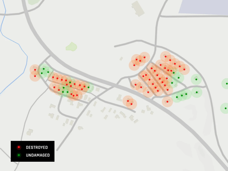
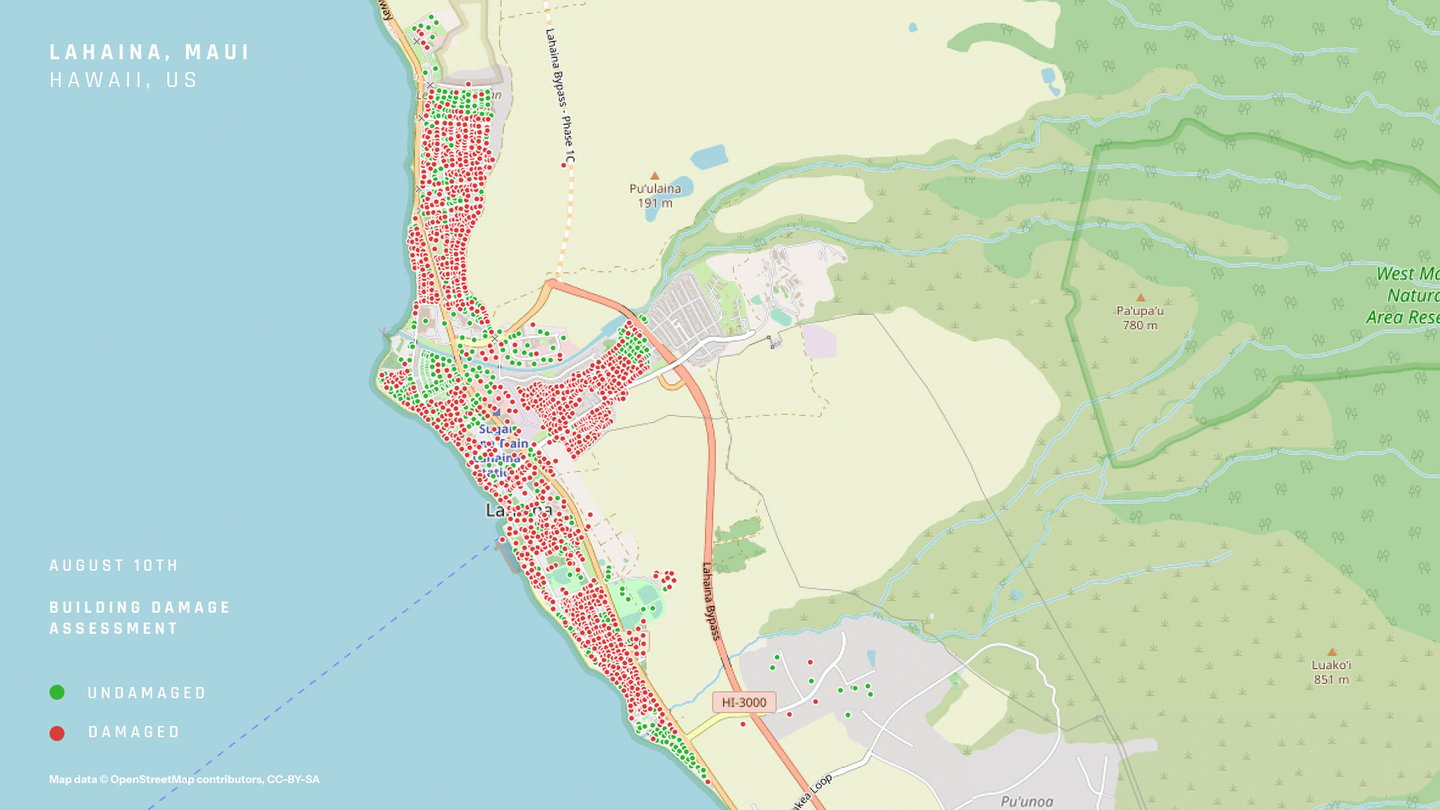
Quickly assess wildfire impacts on individual buildings from inside your GIS platform.

Monitor wildfire damage at the property level

monitor

Improve situational awareness

Monitor active wildfires and their impacts in near real time to confidently deploy resources on the ground. ICEYE synthesizes data from satellites, ground-truth observations, and third-party sources to deliver actionable insights within hours.

act_as_one

Optimize emergency response

Equip various agencies with a single source of truth using ICEYE's wildfire intelligence. Rather than wait days or more for smoke-free aerial images, ICEYE enables emergency managers to take immediate action with GIS-ready impact data.

globe_satellite

Strengthen community resilience

Modernize your disaster response and mitigation with always-on satellite monitoring from ICEYE. With access to geospatial wildfire intelligence, your leaders can better protect their most vulnerable communities and infrastructure.

Ins-Vid-Andy-23

Rapid wildfire situational awareness for the public sector

Andy Read & Shay Strong / ICEYE

Wildfire-render-satellite_hero_small

FAQ: Rapid damage detection with smoke-penetrating satellites.

Triage critical resources with automated damage assessments

Governments have traditionally relied on ad hoc aerial flyovers to assess wildfire damage on the ground. But these overhead photos are not only obscured by smoke and darkness, they also require manual annotation to identify and assess critical infrastructure. ICEYE changes that.

The Wildfire Insights solution delivers unprecedented situational awareness during wildfires by using space-based radar to avoid the inherent limitations of optical imagery. This GIS-enabled solution combines satellite remote sensing, observational ground truth, and third-party data to provide rapid and reliable wildfire intelligence before the smoke has cleared.

Wildfire monitoring footprint | ICEYE

Automated building damage assessments

ICEYE leverages sophisticated remote sensing to automate the damage assessment process. Visualize your exposures with GIS-ready vector layers (building footprints or lat/long points). Damage insights are updated daily and use a binary (destroyed/undamaged) classification for each structure.

ArcGIS live wildfire monitoring from ICEYE

Active wildfire monitoring in ArcGIS

ICEYE also offers a web-based wildfire monitoring application hosted natively in Esri's ArcGIS Experience Builder. The web app visualizes wildfires with a variety of interactive features, including active wildfire perimeters, hotspots, building footprints, populated urban centers, and more.

Hawaii wildfire structural damage assessment map Maui, Hawaii wildfire impact area

ICEYE's structural damage assessment from the Lahaina wildfire in Maui, Hawaii | August 10, 2023

Partner Webinar

Introducing ICEYE Wildfire Insights with advanced monitoring and damage assessment

Reimagine wildfire resilience with satellite-powered intelligence

While satellites were previously reserved for national governments, the blossoming "New Space" industry has democratized access to Earth observation. Today, using the "satellite-as-a-service" model, even state and county governments can leverage remote sensing satellites for disaster intelligence at the local level. Discover how your communities can improve wildfire resilience by tapping into ICEYE's world-leading constellation of SAR microsatellites.

globe_satellite

Persistent monitoring

ICEYE delivers unparalleled situational awareness by operating the world's largest constellation of SAR satellites. With unimpeded remote sensing and multiple daily revisits, you'll have rapid and reliable insights during active events.

satellite_clouds

Uninterrupted capture

Because SAR satellites observe Earth with radar waves instead of optical sensors, they ensure reliable captures in any conditions. This visibility through smoke, clouds, and darkness means your teams can respond faster on the ground.

document_search

GIS-ready insights

The Wildfire Insights solution delivers GIS-ready intel to support rapid emergency response. Leverage your existing GIS software to provide a single source of truth (and seamless updates) to multiple agencies and departments.

fast_icon

Daily updates

ICEYE collects and synthesizes new data throughout the day to produce a single, actionable update every 24 hours. We analyze data from satellites, observations, and other sources for a holistic view of local impacts.

Wildfire_Firefighter_smoke-cloud_hero_small-1

Ready to strengthen your community's wildfire resilience?

Other perils

Product

Flood Insights

Immediately understand the impact of floods and base your decisions on reliable, near real-time flood extent and depth data.

Flooding_Suburban-houses_onethird

Beta

Wind monitoring

Gain access to situational awareness and near real-time damage data related to storms that occur across the globe.

Hurricane-satelllite-render_onethird

Beta

Earthquake monitoring

Embrace a proactive approach with ICEYE’s actionable insights before, during, and after an earthquake.

Earthquake_Turkey_onethird

How can ICEYE support your community resilience plan?