Contact us
Get in touch with our experts to find out the possibilities daily truth data holds for your organization.

Power grids and water systems are the backbone of modern civilization. According to the EPA, the U.S. electrical grid encompasses more than 7,300 power plants, nearly 160,000 miles of high-voltage transmission lines, and millions of miles of low-voltage lines and transformers, serving around 145 million customers. There are also approximately 148,000 public water systems in the U.S.
These systems ensure that homes are powered, hospitals remain operational, industries stay productive, and communities stay connected. Yet, this lifeline of society is increasingly at risk. Extreme weather events are exposing vulnerabilities in infrastructure that was largely designed for a different era.
Every year, hurricanes, floods, and severe storms cause cause billions in damage across the electric grid and water systems. Not to mention, energy restoration time and access to quality water put significant pressure on utility operators and local government officials.
According to the U.S. Department of Energy, U.S. electricity customers endure $25-50 billion annually in losses from sustained power interruptions - over 70% of which are borne by commercial operations.
Using SAR (Synthetic Aperture Radar)-derived data, electric and water utilities can identify infrastructure at risk, reducing power downtime and expediting water service restoration. Since 2020, ICEYE’s SAR satellites have captured flood extent and water depth data covering over 113,870 square miles. in the U.S., including hundreds of utilities and water infrastructure at risk.
The margin of error is narrowing, and the need for faster, smarter responses has never been more urgent.
Traditional damage assessment relies heavily on ground crews, aerial flyovers, and optical satellite imagery. While useful, these approaches cause work force challenges and delays:
In the face of intensifying natural disasters, these traditional methods are no longer sufficient. Utilities need solutions that deliver resilience before, during, and after a storm.
.png?)
SAR satellite constellations are setting a new standard of resilience with persistent, all-weather monitoring. SAR provides near real-time, high-resolution insights that enable utilities to act decisively.
SAR satellites are not hindered by weather or lighting. They can “see” through clouds, rain, and darkness, ensuring that utilities have uninterrupted access to critical intelligence when it matters most.
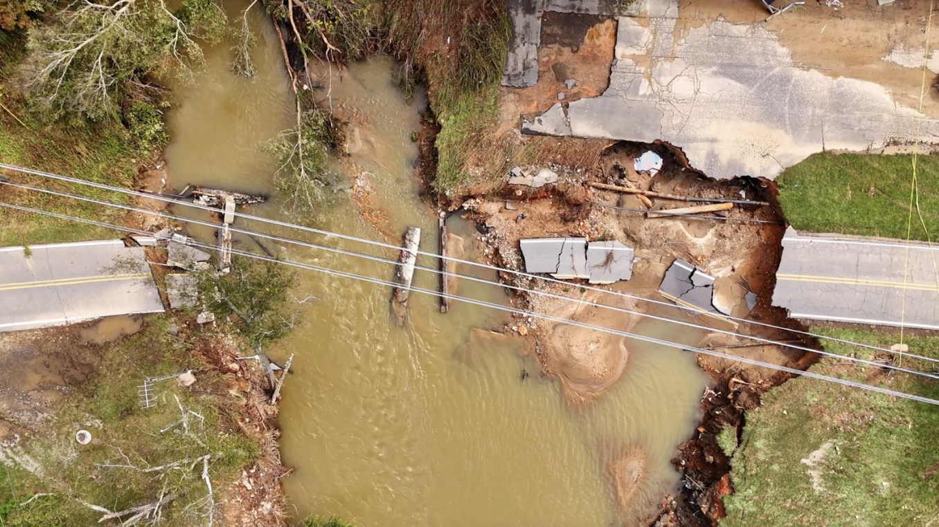
After a major storm, utilities often face challenges assessing the full scope of damage because traditional optical imagery—whether from satellites, planes, or helicopters—is limited and delayed by cloud cover and daylight. By the time aerial images can be captured, floodwaters may have already receded, obscuring the true extent of inundation. This makes it difficult to determine flood boundaries and building impacts. In contrast, ICEYE’s SAR sensors can penetrate clouds and capture conditions in real time, providing clear insights into flood extent to identify impacted substations and other utility infrastructure as well as the impact on customers and to prioritize restoration efforts.
For Hurricane Helene, ICEYE delivered near real-time flood extent and depth data, enabling emergency management agencies to assess the impact on 177,159 buildings across the Southeast, including significant flooding in Asheville, NC (more than 400 buildings just in the city limits).
Several electric and water utilities in the Southeast leveraged ICEYE Flood Solutions for near real-time situational awareness, allowing them to prioritize crews, identify dangerous areas, and restore power and water services more quickly based on precise SAR data, rather than waiting days for aerial or ground assessments to reveal the damage.

Here are five ways SAR-powered solutions empower utilities to get operations up and running within a matter of hours instead of days:
Electric and water utilities cannot afford to be reactive. The era of climate uncertainty demands proactive resilience. Persistent, all-weather monitoring from SAR satellites represents one of the most effective tools available today. By adopting SAR technology and data solutions, utilities can:

25 June 2026

22 June 2026

03 June 2026