Contact us
Get in touch with our experts to find out the possibilities daily truth data holds for your organization.

Tom Ager presented the first three talks in our Value of SAR webinar series, walking us through the basics of SAR technology, the wealth of information in SAR imagery, and the unique capabilities that only ICEYE SAR can offer — like truly persistent monitoring with the world’s first Daily Coherent Ground Track Repeat capability. With his unique ability to talk about SAR in a way that’s understandable and down-to-earth, Tom proved that SAR is an exciting (and fun!) topic for scientists, experts and really anyone.
This blog highlights a few of the key take aways from Tom’s webinars. You can find the recordings in full length on our Value of SAR webpage. Each is about 30 minutes long and absolutely worth watching:
“Tom Ager has done a masterful job of presenting SAR concepts in word and animated graphics. This is both: a great basics refresher for those who are already familiar with SAR and a great technical introduction for mentoring young engineers! THANKS!!”
- Participant’s feedback
Experience Tom Ager’s captivating presentations!
SAR brings tremendous benefits to the Earth Observation (EO) industry and community. As an active system, SAR provides the unique advantage of acquiring images day and night, since no sunlight is needed. And it has the unsurpassed ability to penetrate clouds, rain, fog and smoke. This makes SAR one of the most reliable EO technologies out there, since the planet is dark half of the time and is heavily or even fully clouded in many places. In polar regions, darkness even lasts for several months per year.
To understand SAR technology, it’s important to know how SAR sensors work and what they actually measure. Watch the clip below — a short excerpt from Tom's webinar — in which he talks about how SAR sends radar pulses measuring the range to the ground and the strength of the echo.
Tom Ager explains how SAR works in his first talk ‘Join the SAR Journey’.
As one of the fundamental topics in the Value of SAR talks, Tom points out that, unlike optical systems, SAR delivers not only amplitude but also phase images. What is “phase,” you ask? Well, according to Tom, it’s going to become an increasingly game-changer source of information thanks to its superior precision:
“Phase is the most precise measurement we can make and is the basis of radar imaging. (...) In the coming years, we're going to have to find a way to make phase information easily available and consumable to regular users, not just scientists and engineers, because without that, the richest of SAR cannot be available to people.”
Throughout the session, Tom takes the time to really explain the core SAR terminology, making sure it’s understood correctly and providing the audience with a great starting point for further immersion.
Watch Tom’s brilliant explanations in his first webinar ‘The SAR Journey’.
In his second webinar, Tom focuses on the information SAR imagery delivers from the ground and explains how to interpret a radar image. He walks us through all the relevant parameters that influence the brightness and locations of the pixels that build an image.
The way in which the emitted radar pulse is scattered on the ground provides information about the surface structure, objects and conditions in the image. The different pulse reflections result in pixels of different brightness — from light to dark and shades of gray in between. Tom takes us step-by-step through all of the different backscatter mechanisms, showing us image examples of direct, diffuse, and dihedral reflection as we go in order to help us really see and understand the effects.
“To understand a SAR image, you need to think about the direction of the illumination and how things are reflecting from the ground in the structure of the ground objects.”
Tom also outlines the influences of several other effects on the SAR image, like the dielectric constants and the topographic effects shadow, layover, and foreshortening — all in a way that’s easy for any listener to grasp. He also explains why speckle noise shouldn’t actually be called “noise,” why moving objects are displaced on SAR images, and much more.
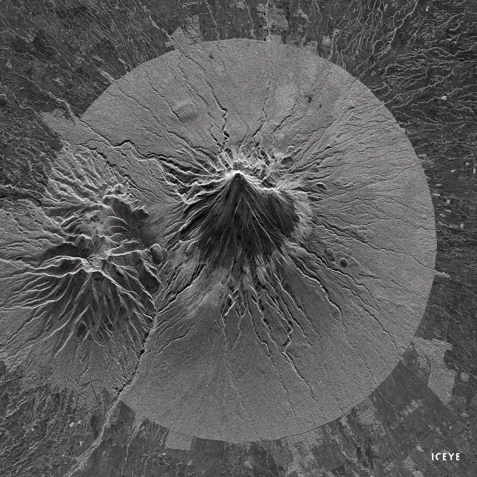
ICEYE SAR image of Mount Taranaki, New Zealand showing the effects of foreshortening, layover and shadowing. The area was illuminated from the top.
Listen to Tom’s inspiring introduction to SAR image interpretation and enjoy the beautiful and information-packed image examples he shares along the way. See what you can get out of SAR images and why the information SAR images provide is so unique. Watch ‘See the World Through SAR’.
SAR is a complementary source of information to many other remote sensing and geospatial data. And it’s a real champion when it comes to the detection and monitoring of changes on our planet — from large scale to microscale.
SAR is capable of taking images in different modes with varying pixel resolutions and scene coverages. ICEYE’s Spot and Spot Extended Area, Strip, and Scan imagery modes provide unprecedented visibility and flexibility, allowing you to monitor areas up to 50,000 km2 and zoom in to areas of interest under one meter. This is a huge advantage that enables a broad range of operational approaches and applications depending on your needs.
With the world’s largest SAR constellation, ICEYE is pioneering the SAR market by enabling unlimited global access and the highest frequency revisits available — measured in hours instead of days. Only ICEYE’s small and agile SAR satellites can enable observation of the same location every day — and even sub-daily — at the exact same time with the same exact acquisition parameters. Daily Coherent Ground Track Repeat data is ideal for persistent monitoring and long-term change detection because anything in the image that hasn’t changed will always appear the same, making even the smallest changes clearly visible and quick and easy to identify.
Another way to make changes on the surface visible is to combine multi-temporal images and merge them in different colors to see if any changes have occurred. The figure below shows the example of ships in the port of Rotterdam in the Netherlands on two different days.
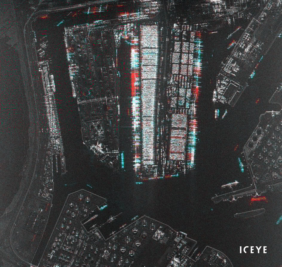
Multi-temporal amplitude images of the port of Rotterdam, The Netherlands. Red colored ships were present in the first image acquisition, blue ships in the second image acquisition. White/gray ships were in the same spot on both days.
Phase images deliver even more highly detailed information and take change detection to the next level. With the very sensitive method of coherent change detection, it’s possible to detect and visualize even millimeter or centimeter-level pixel changes between two data acquisitions.
Daily Coherent Ground Track Repeat data stacks also enable us to measure topography and ground motion using (differential) interferometric technology. We can calculate the heights of buildings and make digital elevation models, and measure ground subsidence and buildings moving in and out over time from persistent scatterer interferometry.
Watch the third Value of SAR talk ‘The Diversity of ICEYE’s SAR Products' featuring Tom’s detailed explanations and amazing visuals.
As a leader in commercial SAR technology, ICEYE is passionate about deepening the understanding of SAR data and driving its use in new and truly transformational ways. We want to lower the entry bar and enable all users to harness the power of SAR to solve many of the problems our rapidly changing world and humanity are facing.
One of the ways we are doing that is our Value of SAR talk series, which we hope will grow the community of people interested in SAR, convey the immense value of SAR data, and help democratize SAR data so that it can be used in a wider range of applications and benefit a greater number of people.
You will find all our past webinars and information about the next ones on the Value of SAR webpage. We encourage you to tune in and watch the sessions whenever you have time and as often as you like.
All webinar recordings are permanently accessible.

03 June 2026

23 January 2026

06 November 2025