Contact us
Get in touch with our experts to find out the possibilities daily truth data holds for your organization.

Many in the remote sensing industry still think of Synthetic Aperture Radar (SAR) as complicated, incomprehensible, meant only for researchers, and as a niche technology in the Earth observation (EO) landscape. It’s true that SAR images can’t be interpreted as intuitively optical data, which essentially look like a photograph of whatever it is you’re observing on the ground. But when you dive a little deeper, it’s easy to grasp the unique opportunities and value this technology truly brings to the market, like the ability to persistently monitor and detect changes to any location on Earth – day and night and even through the clouds.
Today, the Earth observation industry is moving faster than ever. The New Space industry has accelerated the development of new systems and capabilities, and some traditional mapping approaches have been adapted or replaced. This makes it all the more important to keep the market and industry players up to date with the latest evolutions.
ICEYE has set itself the task to educate and inform about SAR and and its emerging capabilities for monitoring our planet to ensure that SAR is recognized as a valuable and indispensable asset.
The perception of SAR imagery is often that it’s black and white, difficult to understand, complex to use, and complicated and expensive to access. Optical remote sensing image data, on the other hand, has been on the commercial market for a long time and is well understood. These are important and project-critical criteria, so it’s not surprising that the standard selection of remote sensing data consists mainly of optical images.
Traditionally, SAR satellites have been part of government programs. They’ve built large, heavy, and costly spacecraft that provided imagery at relatively low repetition rates at a comparatively high cost.
This changed with the start of New Space missions. New Space companies like ICEYE aim to develop and build small, lightweight, and very cost-efficient spacecraft with the goal of operating large satellite constellations. And this has opened up a completely new era in SAR remote sensing.
ICEYE was the world’s first company to launch a SAR satellite weighing less than 100 kilograms and is now operating the world’s largest SAR satellite constellation, designed to deliver daily and even sub-daily information on any point on the globe.
With the skyrocketing number of available and accessible SAR images, the development of SAR data processing and application tools has increased tremendously. This facilitates the use of SAR-based information and opens up the exploitation of SAR capabilities relevant to a wide range of applications, such as emergency and risk management, natural disaster response and recovery, border security, and maritime awareness, to name a few.
With the new opportunity of large SAR satellite constellations guaranteeing high revisit rates, SAR has become an indispensable component of standard remote sensing applications.
Unlike optical systems, SAR sensors emit their own energy to illuminate objects or areas on the ground and record what’s reflected back from the surface to the sensor. This provides the unique advantage of being able to acquire images day and night, since no sunlight is needed.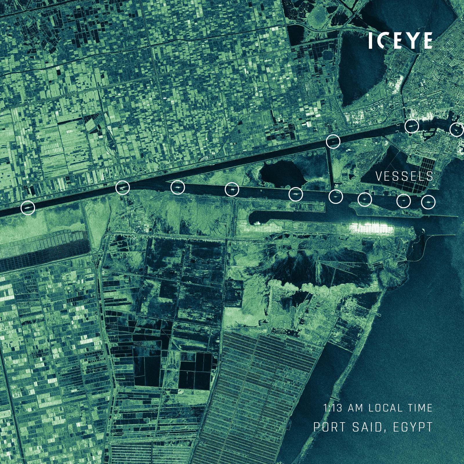
Figure 1. SAR image of the northern end of the Suez Canal near Port Said in Egypt, taken at night.
SAR also uses microwaves in the centimeter range. This gives SAR the unsurpassed advantage of penetrating clouds, rain, fog and smoke. That means that even if an area is permanently cloud-covered or a volcano is smoking and spewing ash into the air, it’s possible to get detailed information on what’s happening on the ground.
SAR sensors can operate in multiple imaging modes and capture images with different resolutions and coverage. This gives you even more flexibility, as well as faster and more accurate information that allows you to make more timely strategic decisions.
This makes SAR imagery unprecedentedly valuable in detecting sudden events and crisis situations that require rapid response. In the case of natural catastrophes that are obscured by cloud cover or smoke, or occur during the night, SAR imagery is often the only reliable source of onsite information.
SAR is known as a 24/7 all-weather sensor, which it is. And because of that, it’s the only technology that can truly provide persistent monitoring.
SAR data provides unique information that no other technology can. Unlike optical imagery, SAR data includes not only the amplitude but also the information of the phase, the fraction of the wavelength of the backscattered signal.
This additional information can be used to measure changes in relative elevation over time using two or more images over an area of interest. This enables the monitoring of subsidence or deformation of areas or the identification of unstable infrastructure. These measurements reveal changes in vertical dimension in the order of millimeters – all from space.
Another unique SAR feature is coherent change detection. By comparing two or more images you can clearly see where changes have happened between acquisition times. This technique identifies changes in the sub-pixel range – some even invisible to the eye. For example you can see things like if an unpaved road had been used or if work had been done at a construction site.
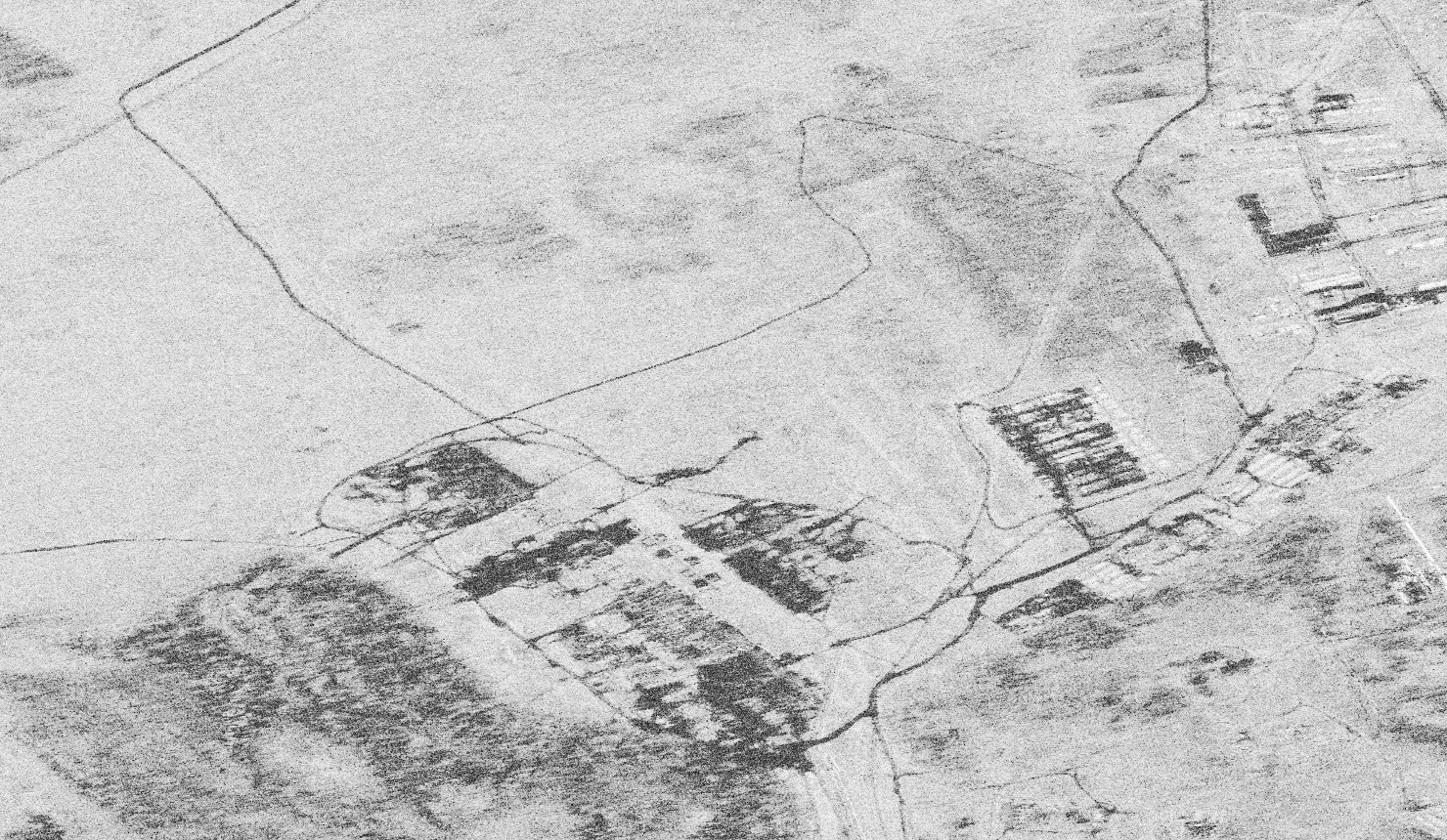
Figure 2. Example of coherent change detection: vehicle traffic through fields between January 21/22 and January 22/23, 2022.
With all of these unique advantages, SAR is a valuable asset with the power to enhance existing applications and enable entirely new ones. Today, there are many data processing, filtering, classifying and analyzing tools available on the market that allow users to exploit these powerful datasets.
Industry professionals are now changing their perception of SAR as a complex, difficult, black-and-white-only remote sensing source. Instead, they are finding new insights and actionable intelligence to make strategic decisions, respond to natural catastrophes and more – faster and more accurately than ever before.
As a leader in commercial SAR technology, we at ICEYE aim to contribute to the better understanding and increasingly diverse use of SAR data. And we want governments, scientists and organizations to be able to harness the power of our technology to find answers to the problems of a rapidly changing world.
To do that, we’ve launched ‘The Value of SAR’ talk series. In six short webinars, we’ll explore the basics of SAR, unique products, and intriguing applications and solutions enabled by SAR. You’ll come away with great insights into SAR technology and learn all about the unique value SAR brings to the Earth observation industry.
🛰 We are thrilled to announce the launch of our #TalkSeries ‘The Value of SAR’!
— ICEYE (@iceyefi) April 7, 2022
This #webinar series aims to challenge the prejudice that Synthetic Aperture Radar (SAR) technology is incomprehensible and overly complex.#ValueOfSAR pic.twitter.com/6VRgGaP21b
All of this will be presented by our renowned SAR experts Tom Ager, Shay Strong, and Darren Muff, all of whom are well-known for their natural ability to explain even complex issues simply and clearly.
The talks are designed for anyone interested in SAR, from beginners to SAR enthusiasts – no prior knowledge is required.
The value of SAR
Get introduced to the basics of Synthetic Aperture Radar by Tom Ager - watch the recording of our "Join The SAR Journey" talk.

03 June 2026

23 January 2026

06 November 2025