What if you could find and monitor oil spills in near real-time, day or night and in any weather? With ICEYE's SAR technology, you can.
ICEYE owns and operates the world’s largest constellation of SAR satellites, which is how we are able to capture high-fidelity imagery of the same location on Earth every few hours. This ability to persistently and flexibly monitor any location is a game-changer, enabling a level of insight you’ve never had and response capabilities to match.
Read on to hear how our partners are using ICEYE SAR imagery to see and respond to oil spills in ways that simply haven’t been possible until now.
WHAT MAKES ICEYE SAR DIFFERENT?
While oil spills have become less of a problem over time, the reality is that 150,000 tons of crude oil are still unintentionally deposited into our oceans every year. That’s more than 65 Olympic swimming pools full of oil. These events cause disastrous environmental and economic impacts, both in the immediate vicinity in which they happen and on a global level that impacts humanity as a whole.
Being able to understand where oil spills are happening and whether they are accidents or the result of illegal activity is something that’s very important and very difficult. Earth is covered by massive amounts of water and to be able to survey that at high-frequency and high-resolution is impossible without persistent asset monitoring from space. And that’s something only ICEYE can deliver.
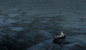
A damaged crude oil tanker causes a large oil slick in the Gulf of Oman. The dark water areas indicate oil.
ICEYE’s SAR system is particularly suited to mitigating the effects of oil spills. Our satellites are excellent at detecting the difference between oil and water in large open bodies of water. They can collect imagery of areas up to 10,000 square kilometers in size – very frequently and in a single pass. Once an oil spill is detected, they can zoom in at even higher fidelity and collect images with a resolution of up to 25 cm.
As a SAR system, ICEYE’s satellites are also able to see through clouds and fog, both of which are often present in maritime environments. And unlike optical satellite systems, SAR doesn’t need the sun’s rays to capture change, which means ICEYE’s satellites can also see in the dark.
ANSWERING A CALL IN THE MIDDLE OF THE NIGHT
ICEYE’s technology provides nations with capabilities they’ve never had before. And monitoring oil spills is a perfect example of how our technology can solve a major pain point for our customers.
One example of that is a call that ICEYE received in the middle of the night in 2021 from one of our national partners. A major oil spill had occurred off of their coastline, threatening the ecological activity in the region and impacting the tourist season, which was about to be in full swing. Despite their best efforts, they were unable to find the oil. Within 6 hours, we had not only located the oil but delivered a report that measured the thickness of the oil on top of the water. This allowed them to not only find the missing oil but to plan the right response with the right resources to clean it up as fast as possible. Their response was essentially “Wow, this is a capability we’ve never had before and we would not have been able to do this without ICEYE’s system.”
Today, ICEYE is responsible for monitoring this nation’s entire coastline 24/7. And in addition to using ICEYE’s system to monitor oil spills, they’re also using it to monitor fixed equipment like oil drilling platforms. So this nation can now go from reacting to a spill from a vessel that’s taking oil from a platform to some other location to proactively monitoring the platform itself to determine if there’s an issue at the source.
This ICEYE SAR image shows a possible oil spill emanating from one of the oil rigs in the North Sea.
FINDING THE NEEDLE IN THE HAYSTACK
Finding oil spills in massive bodies of water is the ultimate “needle in the haystack”. And it’s now easier, faster and more accurate than ever before with ICEYE’s technology. The agile operations environment we’ve built enables us to identify where a spill is now, where it may be going based on our observations and analysis of things like weather and currents, and who might be impacted – all within just hours of an event. Armed with that information, our partners can act faster and more effectively than ever before.
The ability to react and capture information in a very timely way is the most powerful thing we can offer our partners and the individuals that consume this information.