Contact us
Get in touch with our experts to find out the possibilities daily truth data holds for your organization.

In the summer of 2019–2020, Australia’s Black Summer bushfires scorched millions of hectares, killed and displaced wildlife, and left communities struggling to breathe under walls of smoke. Thousands of homes were lost, and emergency services fought in conditions that defied normal operational logic. Aerial and optical imagery programs generated petabytes of data and yet very little of it shaped real-time operational decisions.
As one Australian government leader later reflected:
"We often won't get accurate satellite imagery on the fire area until after the smoke has cleared and we get a clear day," SAID Michelle Damen From VICTORIA's State Control Centre, speaking to ABC News.
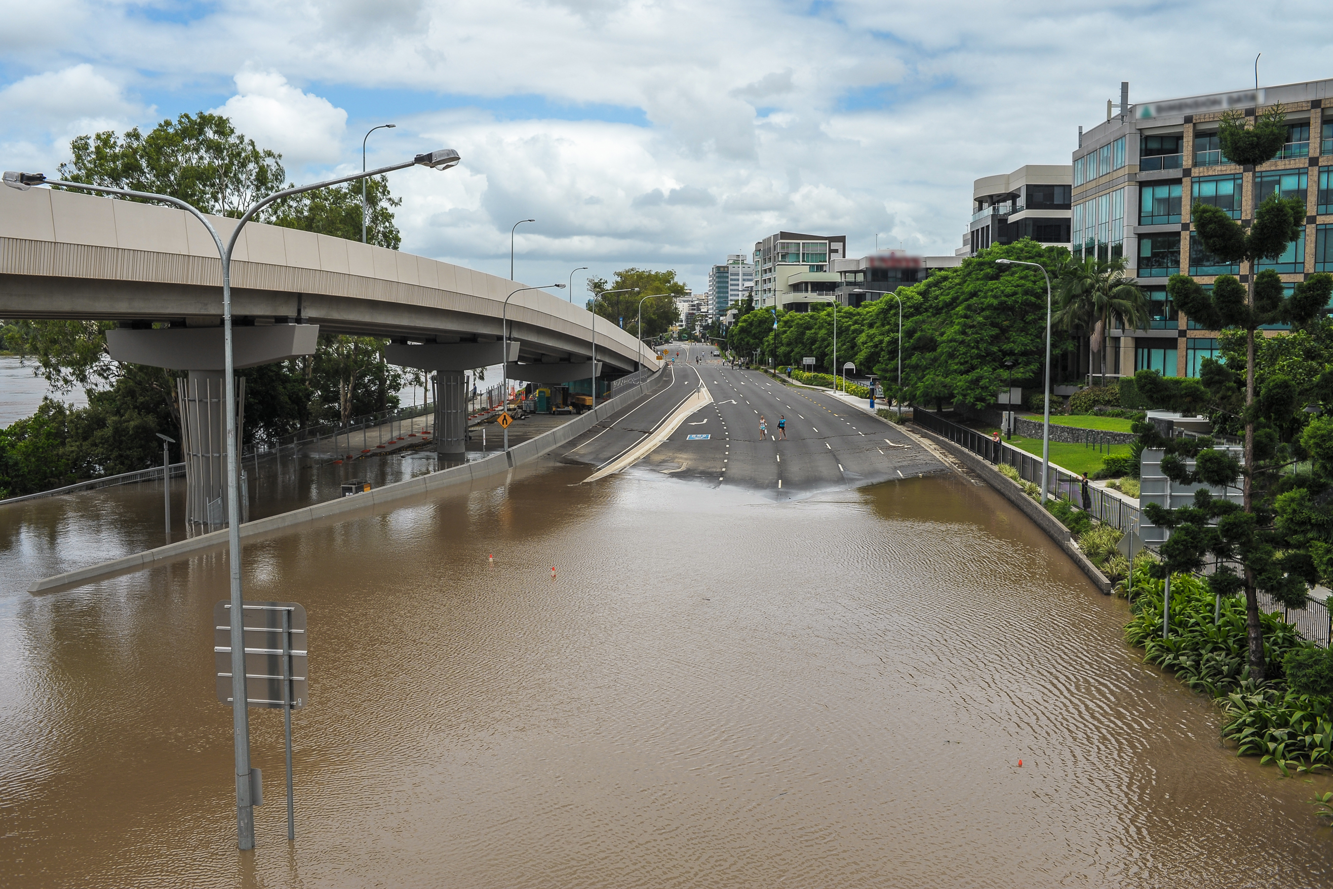
Then came the floods. In early 2025, record rain triggered devastating flooding across Queensland and the New South Wales Mid North Coast, isolating tens of thousands of residents, cutting supply chains and claiming lives in towns such as Taree and Kempsey. Traditional situational awareness tools again struggled to keep pace with a landscape that was changing faster than models could predict and faster than ground crews could assess.
On the ground, incident controllers were making life-and-death calls in minutes. But the intelligence cycle that supported them moved in days and weeks. Government agencies acquired imagery that required further processing and rapidly lost value.
The failure was not a lack of data. It was a lack of decision-ready intelligence. What agencies needed was data that could match the tempo of emergency decisions. This was the gap synthetic aperture radar (SAR) was built to close: to deliver answers where and when they matter, even through smoke, cloud and night.
In 2019, what most agencies described as “traditional disaster intelligence” relied on a combination of optical satellite imagery, crewed aircraft observations, and ground reports. However, under conditions of fire and flood, each of these sources shared a critical weakness: their reliability deteriorated precisely when decision-making pressure was at its peak.
Optical satellites, for instance, were frequently blinded by dense smoke plumes and unable to penetrate thick cloud cover. Their effectiveness was further constrained by dependence on daylight and limited tasking windows. Even when imagery was successfully captured, it required manual interpretation and verification against ground truth, often resulting in delays of 24 to 72 hours before actionable products could be delivered to operational teams.
Similarly, fixed-wing and rotary-wing aircraft were often grounded during periods of the most severe fire weather. Their deployment was restricted by airspace closures and safety considerations, and scaling their use across multiple concurrent incidents proved prohibitively expensive. In practice, this made it difficult to generate a consistent and repeatable stream of intelligence, particularly as conditions such as weather, smoke, and airspace restrictions evolved rapidly from hour to hour.
Ground reports, meanwhile, were typically fragmented across different agencies and jurisdictions. Their reliability depended heavily on physical access to areas that were often damaged or actively burning, and the information they provided was frequently delayed and inconsistent in structure.
Taken together, this meant ground reporting was often uneven and hard to combine quickly: information arrived in different formats, at different times, and only from places teams could safely reach, which slowed the creation of a single, shared operational picture across agencies.
Agencies don’t struggle from a shortage of imagery and data points. Their biggest challenge is decision-ready intelligence, and that distinction matters. Raw imagery shows what the sensor captured. Decision-ready intelligence answers what the operation needs to know.
For emergency managers, decision-ready intelligence should:
What was missing in 2019 was a reliable, repeatable way to go from pixels to answers fast enough to inform the next operational briefing.
Synthetic aperture radar (SAR) changed the equation for two reasons.
At its core, synthetic aperture radar (SAR) is a sensor that illuminates the Earth and measures the returning signal. Unlike optical satellites, it is independent of sunlight and penetrates clouds, smoke, and rain.
Modern SAR constellations are engineered for high-frequency revisit rates. This allows satellites to provide insights on active hazards, including floods, bushfires, and cyclones. SAR provides near real-time intelligence required for active response rather than just post-event analysis.
This shift directly aligns with Australia’s emergency management priorities, where national frameworks emphasise that “communities, leaders, and stakeholders make effective decisions through decision support information and predictive analysis.” Near real-time SAR intelligence strengthens that decision-support layer, ensuring predictive models are continuously validated against observed reality.
In practical terms, during a major event SAR can be used to expedite decision-making by refreshing national-scale situational awareness in hours, not days. SAR satellites can observe the same region again and again in near-real-time. These constellations can also feed automated analytics that produce flood extent, depth estimates, and change detection.
Resolution still matters. But in a live emergency, revisit cadence matters more. Incident controllers are working to six-hour and 12-hour decision cycles. Morning and evening briefings. Shift handovers. Cabinet updates.
A satellite scene that arrives three days late at very high resolution is a historical document. A SAR-derived product that arrives every six hours at moderate resolution, aligned to those briefings, is an operational tool.
.png?)
Recent East Coast flood seasons have shown how quickly conditions can evolve across multiple river systems and catchments. Traditional flood modelling gives valuable forecasts, but forecasts need to be corrected against what is actually happening on the ground.
SAR-based flood mapping closes that loop by:
This allows national and state emergency management agencies to:
In practice, SAR flood intelligence plugs into the same workflows that rely today on flood modelling for government river gauge networks. It does not replace them. It makes them honest during the event.
The video below depicts how ICEYE was able to capture flood depth regardless of daylight or weather conditions using ICEYE Flood Insights.
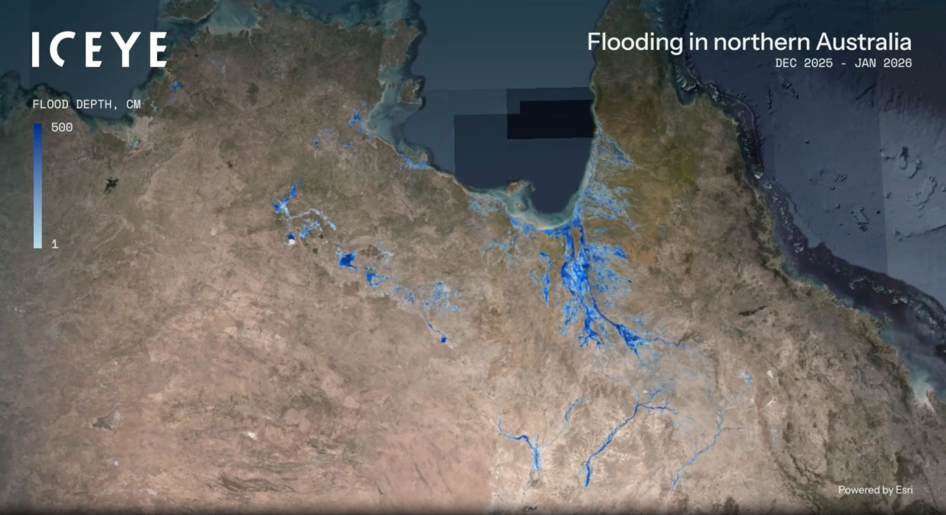
ICEYE Flood Insights
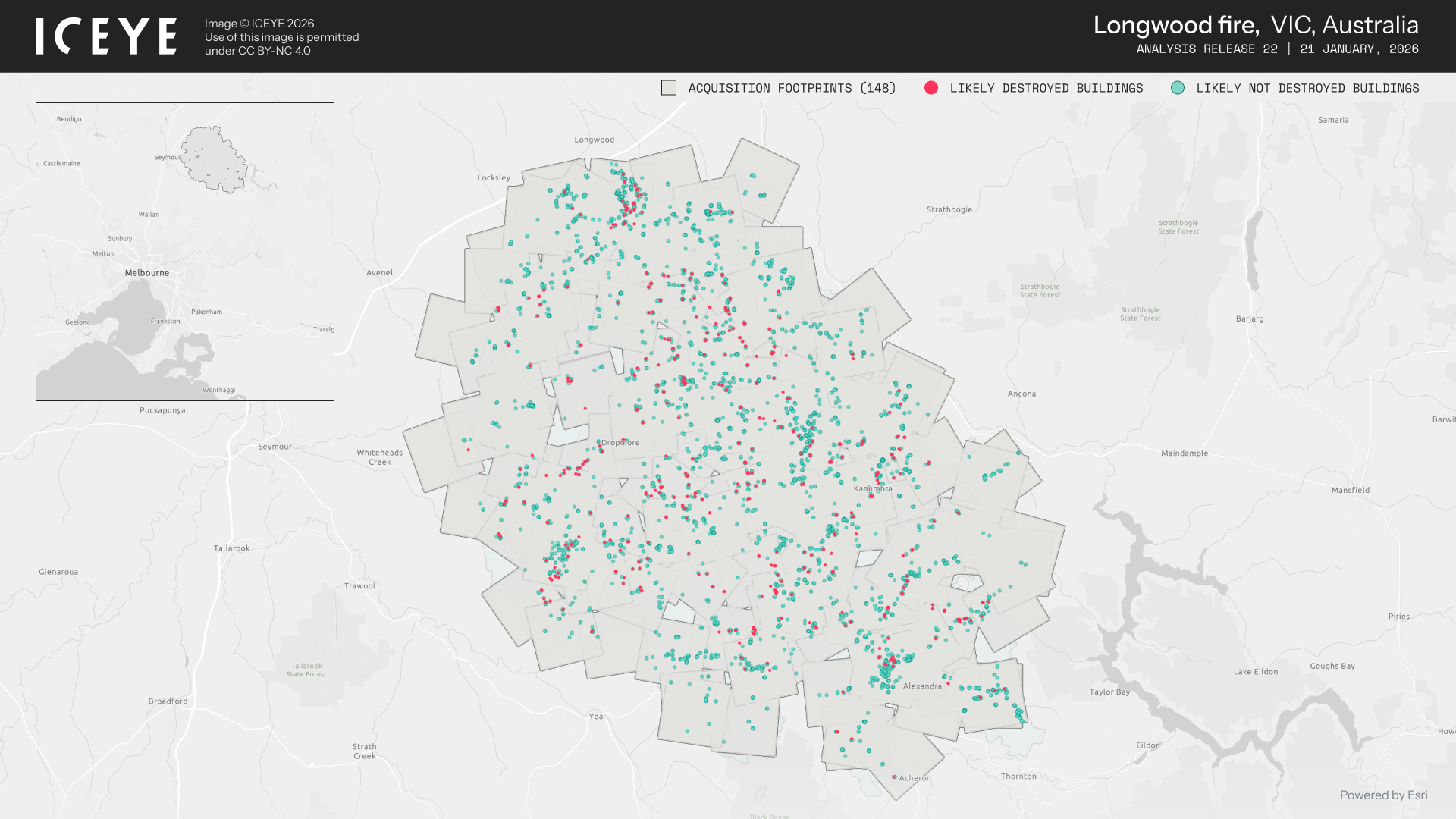
The January 2026 Victorian bushfires illustrated a detrimental visibility problem: Smoke can make fixed-wing assessment flights unsafe, impacted communities can sit under thick smoke for days, and outages caused by fire can complicate reporting from the ground.
SAR-based damage assessment added a missing layer which included classification of likely destroyed and intact structures and alignment of results with address and infrastructure databases.
One fire complex alone, centred near Longwood, saw hundreds of buildings damaged or destroyed across multiple local government areas. SAR damage mapping helped estimate that impact footprint while smoke still covered the region and many roads were closed.

Pictured above: From January through February, ICEYE monitored 26 fires in Australia, including the Longwood Fire. At the time of analysis, The Longwood fire alone spanned over approximately 132,000 hectares. Zoom in here to view in detail.
Damage counts are not academic. They drive:
Transport and infrastructure agencies have been among the earliest adopters of SAR-based intelligence, as they face a challenge similar to that of emergency services: critical asset decisions depend on timely, verified information about ground conditions, particularly when visibility is poor and conventional reporting systems begin to fail. Following flood events in New South Wales, for instance, transport planners and asset managers must determine which road segments have been inundated and for how long, identify where embankments and cuttings may have become destabilised, assess which rail corridors have been undermined or obstructed by landslides, and evaluate how quickly crews can safely access remote bridges and culverts.

During the flood event in Tweed Heads, New South Wales, ICEYE’s Flood Insights data supported situational awareness and validated flood impact assessments for Transport for New South Wales.
SAR flood products give them a single, consistent view of water over roads and rail, including in remote areas with poor reporting, as well as alternative corridors that remain dry and passable.
The same logic applies directly to agriculture and regional logistics. In many parts of Australia, the “critical corridor” isn’t a commuter line, its stock routes, cattle tracks, feed delivery roads and tanker access to remote properties.
If a regional council or state transport agency can see that a causeway is under two metres of water while a nearby ridge road remains dry, that informs both evacuations and freight planning. Farmers, cooperatives and logistics firms all benefit from that same picture.
“We see ICEYE playing a supporting role in both emergency response and recovery—particularly in verifying and enhancing the accuracy of data we receive from other sources. In the future, ICEYE could help resolve discrepancies between datasets, especially where ground reports, models, or third-party tools present conflicting information.”
-Sharad Joshi, Senior Manager, ESCEM Insights & Solutions, Transport for New South Wales
The shift from the Black Summer era to today represents a move from raw data to operational intelligence.
2019: Imagery existed, but operations couldn’t use it fast enough
Today: Decision-ready SAR intelligence is operational by design
The ICEYE partnership with Esri Australia and Boustead Geospatial is one example of this shift. SAR-based flood and bushfire layers are being made available as ready-to-use services inside ArcGIS for Australian councils, utilities and emergency services, removing the integration burden that slowed adoption during Black Summer.
Users do not have to learn a new tool. They see SAR-derived layers sitting alongside Bureau of Meteorology forecasts, risk scores from organisations such as Cotality, and their own asset data.

ICEYE’s Flood Intelligence Dashboard Courtesy of Esri Australia depicts SAR insights showing the extent of flood damage in near real time.
For federal and state decision-makers, SAR-based intelligence has three roles across the disaster cycle.
Before: Preparedness and forecasting
Before a disaster, it supports preparedness and forecasting by enabling baseline mapping of floodplains, fire-prone corridors, and critical infrastructure, as well as scenario testing for potential failures across rail, road, power, and telecommunications networks. It also plays an important role in calibrating and validating flood and fire models used in national risk assessments.
During: Live response and prioritisation
During an event, SAR provides near real-time insight into the actual location and extent of water, fire, and damage, rather than relying solely on predictive models. It delivers consistent, repeatable mapping that can be readily shared across jurisdictions, agencies, and lifeline operators, while also providing the evidentiary basis needed to support difficult operational decisions such as evacuations, road closures, and the re-tasking of resources. At the federal level, this contributes to a broader whole-of-government effort to build and maintain a national picture of hazard risk, direct investment effectively, and assess the impact of mitigation measures. A shared SAR intelligence layer helps to reduce fragmentation between jurisdictions and strengthens coordinated national response.
At the federal level, this contributes to the broader Whole-of-Government effort to build and maintain a national picture of hazard risk, target investment and understand which mitigation measures are effective. A shared SAR intelligence layer reduces fragmentation between jurisdictions and strengthens coordinated national response.
After: Recovery, funding and accountability
Following a disaster, SAR supports recovery, funding, and accountability by providing transparent records of which communities and sectors have been most severely affected. It supplies data to inform Disaster Recovery Funding Arrangements and reconstruction planning, as well as inputs for insurance, agriculture, and infrastructure resilience investments. Reliable and timely impact assessments also enable governments to deliver targeted recovery assistance more effectively, as validated damage footprints allow funding decisions, inspector deployments, and welfare support to be prioritised with greater precision.
Beyond government use, the same SAR intelligence backbone can support insurers in calibrating event losses across portfolios, improving situational awareness, estimating losses, triaging claims, conducting remote assessments, and managing risk, including in parametric and insurance-linked securities contexts. It can also assist banks and regulators in assessing systemic risk, and support agricultural departments in tracking the impact of flooding on crops and grazing land.
Australia did not just need more data after Black Summer. It needed an operational intelligence backbone capable of supporting response, recovery and long-term risk reduction across the entire disaster cycle. That is what SAR, used as an operational intelligence layer rather than a niche imaging tool, now makes possible.
As someone responsible for supporting government, emergency management, and utilities across Australia, I’ve seen firsthand how expectations have shifted. The question is no longer whether satellite data is available. The question is whether it is operational.
For agencies seeking SAR flood extent data, bushfire damage intelligence, or infrastructure impact assessments, the opportunity now is to embed decision-ready insights before the next event strikes.
“This work on disaster resilience and response isn’t just about recovery — it’s about making sure we learn the lessons from every event so that when the next crisis hits, our decisions are faster, better informed and coordinated. That’s how we save lives and protect communities.”
— Paul Gloyne, Former Assistant Coordinator-General for Data and Analytics, National Emergency Management Agency (NEMA).
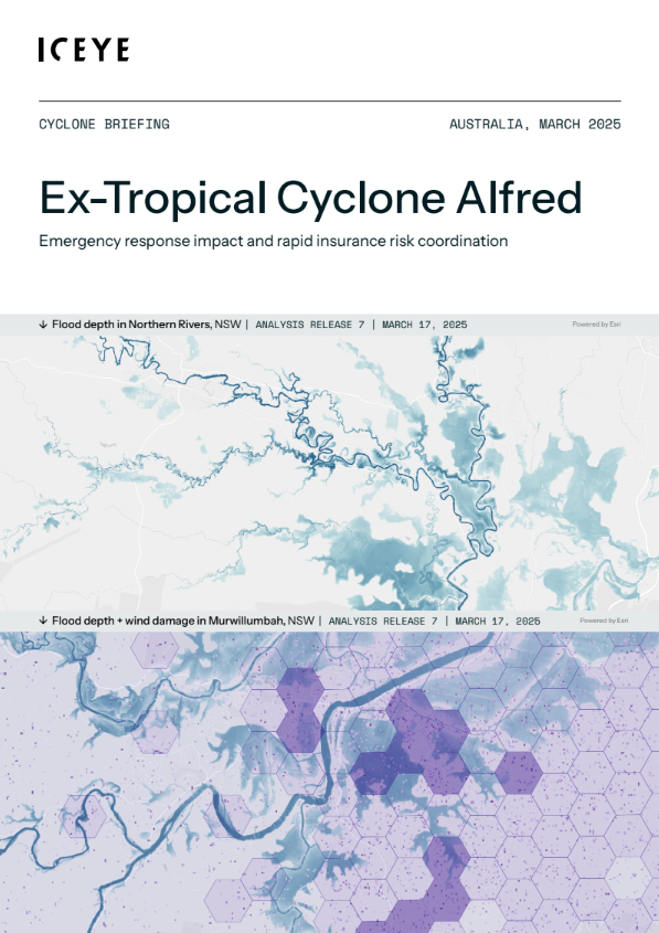
CYCLONE BRIEFING
Download the flood briefing

25 June 2026

14 May 2026

11 December 2025