Contact us
Get in touch with our experts to find out the possibilities daily truth data holds for your organization.
.jpg?width=64&name=pekka-author%20(1).jpg)

ICEYE SAR videos are based on a technique that uses a very-high-resolution synthetic-aperture radar (VHR SAR) satellite acquisition, where a SAR satellite is set to stare at an individual point location for an extended time of 20 seconds or more. ICEYE is then able to process and split the collected data into several separate frames, which can in turn be combined into moving image sequences - SAR videos. These videos allow for further analysis of movement over ground and maritime scenes that happened during the individual satellite pass.
In-orbit demonstration of ICEYE's new SAR video capability.
Although SAR videos can look impressive, their interpretation is more challenging than you might assume at a first glance. This technical blog post is designed to give a short introduction into the technology behind SAR videos and highlight some of the interesting phenomenology seen in this initial SAR video demonstration.
When imaging, the ICEYE SAR satellites transmit thousands of digitally formed radar pulses per second, which then reflect back from the ground, and are combined into a 'synthetic-aperture' image. The pulses that the ICEYE satellites transmit are microwaves that have a wavelength 100,000 times longer than visible light. For ICEYE satellites, this wavelength is about 3 cm long and sits in a region of the electromagnetic spectrum called X-band. This longer wavelength allows the signal to pass through clouds uninterrupted which means that imaging with SAR can happen in any weather. The active transmission of the radar pulses also means that SAR can image independent of sunlight and provide data equally well both day and night.
A single pixel in a resulting radar image represents the amount of energy that reflected back to the satellite within that specific location (e.g. 1x1m grid), creating a high-resolution, grey-scale 'backscatter' image.
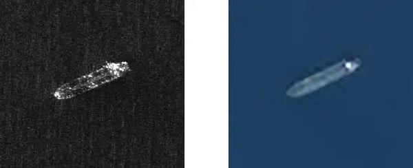
Images of a tanker ship acquired by an ICEYE SAR satellite (left) and Sentinel-2 optical satellite (right) at the same time. SAR images do not have color but provide a measure of the backscatter brightness for each resolution cell. See our principles of SAR explanation to learn more.
A standard video camera captures many individual pictures per second and displays them one after the other very quickly. ICEYE SAR videos are made in a somewhat similar way. Rather than forming the synthetic aperture over all received pulses, several images are formed, each from a subset of the pulses. As the pulses have been taken sequentially over time, this provides individual image frames at different times. By stacking these together and playing them one after the other, a video can be built.
Breaking the synthetic aperture into frames reduces the synthetic-aperture length available for each frame and, as a result, the resolution of each frame is coarser. However, ICEYE satellites have a unique way of getting around this. Since the satellites operated by ICEYE are small, they are quite agile in space and can routinely be pointed forwards to start imaging earlier and stop the imaging operation later by constantly rotating the antenna, along with the entire spacecraft, to accurately track a certain point on ground. Thus, very long synthetic apertures can be achieved which allows the collection of more energy from the target. This technique enables to recover the lost resolution caused by breaking the original synthetic aperture into video frames, or to collect more frames for a longer video.
The main difference between optical and SAR videos is due to the SAR aperture synthesis process. Unlike an optical image that collects all the light from a scene at the same time, a SAR satellite constructs its aperture using digital signals processing to combine pulses taken at slightly different times. The complicating factor relates to how SAR image formation works. The SAR processor uses time and relative motion, or Doppler, to make the 2D image. This process assumes that all scene content is stationary over the coherent dwell. Usually, this does not make a difference as most things on the ground are stationary over the synthetic-aperture time period. Things that are moving, however, cause this assumption to break down. Moving targets do not appear where you might expect compared to static background. Moreover, their motion often causes them to appear defocused. But surprisingly, this effect can provide useful information about objects in the image.
The most obvious effect of objects moving in a SAR image is that their motion can apply an additional Doppler frequency shift. Every point in the image cross-range position has a slightly different Doppler frequency assigned with it. This is how the SAR processor knows where to place pixels in the cross-range. A moving target introduces extra Doppler that adds to what is normally expected at its true location. This confuses the SAR image formation processor (IFP) into thinking that their location is either further ahead or behind their true location. A target moving towards the SAR will be displaced in the direction the SAR is flying. This can be seen in the following animation showing a SAR video of a ship moving through the water.
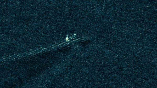
A moving vessel displaced from its wake.
In this example, we can see the wake of the vessel and therefore know where its true location is. The vessel is moving towards the ICEYE satellite, which is flying from right to left, during its pass over the image area. This means that the pulses are returned to the sensor slightly more frequently than they would for a stationary object, and so the SAR processor tries to place them ahead of their true location (where the target is moving towards the sensor rather than behind the satellite where things are moving away).
To analyze this a bit more let us look at four frames taken at the beginning, near the middle and at the end of the synthetic aperture.
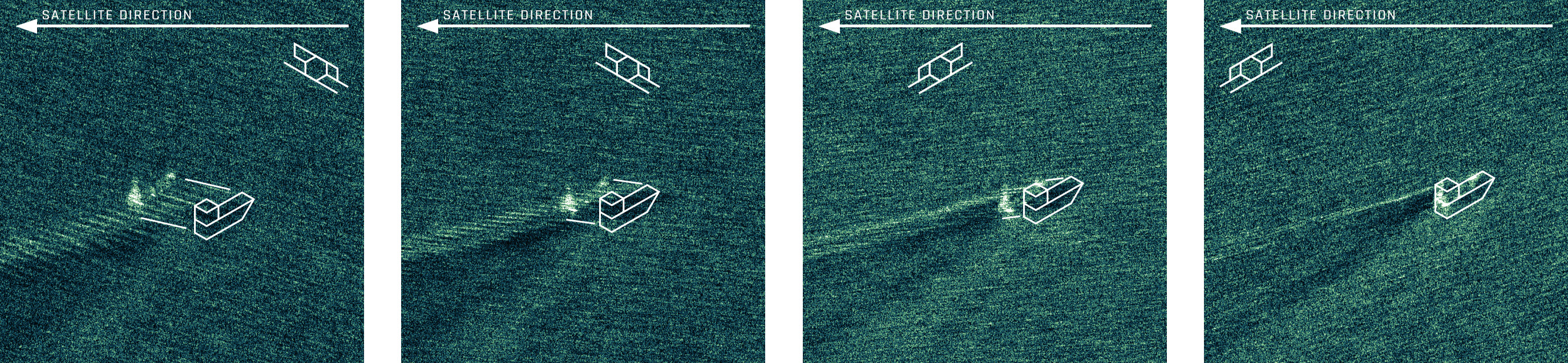
Displacement of a moving vessel in different frames of SAR image acquisition.
In the first frame, the ship is moving almost directly towards the satellite. In this case, the SAR processor measures the additional Doppler shift caused by the ship's movement and places the ship in the wrong location. As the satellite is moving from right to left in this scene, ground items towards the left of the image (ahead of the satellite) are moving towards the sensor, and so the SAR IFP displaces the ship towards the left of the image (in the instantaneous cross-range direction). We can draw lines from the shadow of the ship to its displaced location and use this displacement information to work out the additional Doppler shift and therefore its speed. In the subsequent frames, the movement of the ship towards the satellite is gradually reduced. The ship is slowing down. This has the effect of reducing the additional Doppler shift caused by the ship's movement and so it gradually gets placed back into its true location.
The initial demonstrator video includes five different examples and demonstrates a variety of motion effects. We will discuss each individually in the following.
ICEYE SAR satellite acquisition: 06:15 UTC (15:15 local time).
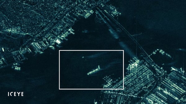
In this example, the ship displacement is obvious but this time the displacement is to the rear of the satellite as it moves away from the sensor. There are also some other interesting features in this image such as the 'flashes' or glinting from the bridge support structures, caused by the changing viewing angle to the target.
ICEYE SAR satellite acquisition: 14:00 UTC (14:00 local time).
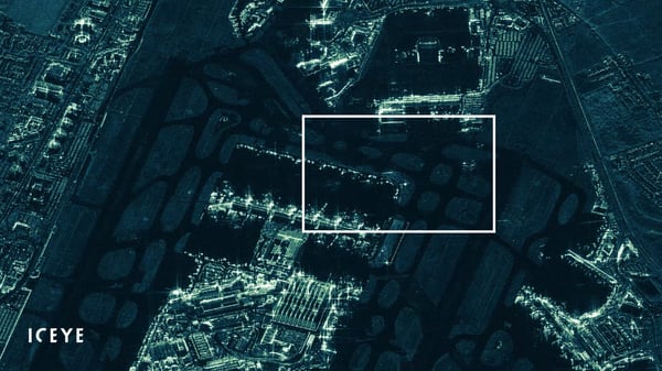
This example shows the Terminal 2 at London’s Heathrow airport. A large aircraft can be seen moving along the front of the Terminal. Since it is moving in the same direction as the satellite rather than towards or away from it, the Doppler frequency shift is largely unchanged.
The movement does cause defocusing of the aircraft as it moves along the front of the terminal. A useful feature of SAR data is that all phase information is collected at the wavelength level, which allows refocusing the image after collection. With adaptive focus we can bring this moving feature into focus. But perhaps even more usefully, we can look at the inner workings of the focusing algorithm that we applied and use the information to determine what caused the defocusing in the first place. In this case the object (presumably aircraft) was moving at a speed of around 24 km/h.
ICEYE SAR satellite acquisition: 11:00 UTC (3:00 local time).
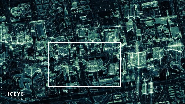
In this example the Bellagio Hotel on the Las Vegas Strip is beautifully captured in the center of the image. However, as the satellite transits past, each building glints as it provides a face that aligns with the satellite’s orientation. What is interesting to see is that the images can be more interpretable when we see these glints – it is almost as if the human brain is better at forming the glints into something that we would expect to see. Try freezing the movie and seeing if you can find features in each freeze frame. Another striking feature of this video are the 'shadows' from the Bellagio and Caesar’s Palace – they are pointed down and swing around as the satellite moves past. These are obviously not shadows from sunlight, but 'radiometric shadows' meaning areas where the radar pulses do not reach because the structures are in the way.
ICEYE SAR satellite acquisition: 22:15 UTC (15:15 local time).
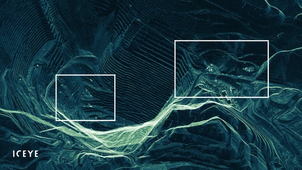
This example shows an overview of an open pit mine. There is a lot going on in this image. Of obvious interest are the seven or more large vehicles driving out of the mine along the road at the center right of the image. Now look at the large hole in the mine and notice the many bright points that are moving around in it. At first glance, this is a bit confusing as the bright features seem to move across the open void. They are caused by vehicles moving along the road at the left of the mine. This road is oriented towards the satellite, and so any motion along it causes vehicles to be displaced off the road due to their additional Doppler shift.
ICEYE SAR satellite acquisition: 05:30 UTC (14:30 local time).
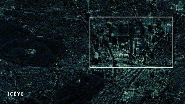
A basic use of SAR videos is the observation of objects from many different view angles as the satellite moves past a scene. This can most easily be seen in this example of Shinjuku Tokyo, with the facets of the buildings becoming brighter as the satellite orientation changes. The brightest return we see when the satellite is facing a wall head-on, like pointing a light at a flat mirror. Also notice that the tall buildings appear to layover or superimposed on top of structures between them and the SAR almost like a double exposure. This is another peculiar consequence of the SAR processor. The IFP uses the timing of the return signal to place pixels in the range direction. Since the return signal from the top of a building arrives before that from the bottom of the building, the top of the building is placed closer to the SAR than its base. So now we see that a SAR can not only be used to measure the speed of some moving targets but can also measure the height of tall buildings.
This initial SAR in-orbit demonstration video is published to share this new and neat information with the community as soon as possible, while we are continuing to develop and release new ways to task our satellites this year. We aim to make this capability available for customers during 2020 in a format that is compatible with most standard GIS tools. The data is planned to be accessible at the level of individual frames from the same acquisition for advanced analysis.
Please stay tuned for announcements on feature releases. Until then, check out our latest commercially available data samples, of high-resolution Spotlight imagery. Sample datasets are available for free download from the Downloads section.
Download 


27 June 2025

13 March 2025

14 February 2025