Contact us
Get in touch with our experts to find out the possibilities daily truth data holds for your organization.


The key to predicting the future is to track trends. To do that, it is important to make many observations and look for event patterns that can be extrapolated to a future time.
Having many past observations and projecting only a short time into the future is obviously important for reducing errors. This is something that traditionally hasn’t been possible with imagery. Until now.
This technical blog gives background information on and insights into the complexity of SAR satellite orbit precision needed to offer a Daily Coherent Ground Track Repeat data series for persistent monitoring and change detection.

Figure 1: What comes next – the key to predicting the future is to spot patterns in the past.
Synthetic-aperture radar (SAR) satellites are inherently designed for change detection (and therefore automation) – images taken from the same location of the same objects are always identical unless something changes. Unlike an optical system, SAR sensors always provide an image - regardless of the time of day or the weather conditions, as the transmitted radar pulses penetrate almost all weather conditions.
The challenge until now has been collecting radar images that are close enough together in time. If images of a location are taken many weeks apart or from different angles, the scene can look very different due to the significant impact that naturally occurring weather events and the everyday comings-and-goings of locals can have on what the radar sees.
That means the next step towards predictive analysis has to be to reduce the period between the observations. This is something that ICEYE has been working hard to achieve over the past year. To understand how we have done that, let’s take a closer look at how orbits work.
A satellite travels around the earth in an orbit. The altitude of the orbit above the earth is purely a function of the satellite's instantaneous velocity. To increase its altitude, a satellite can increase its velocity. To reduce its altitude, it reduces its velocity.
Because the satellite travels in a circle (technically an ellipse), the amount of distance travelled by the satellite in one complete orbit increases if the orbit is higher. This means that it takes longer for a satellite to go around the earth once. This is called the orbital period. What is interesting to note is that the orbital period can be adjusted by changing the altitude of the satellite. Making the satellite have a higher altitude makes the distance travelled for one complete orbit larger, thus increasing the orbital period. Satellites in low earth orbit typically have an orbital period of between 90 and 100 minutes.
 Figure 2: ICEYE SAR satellites orbits
Now consider a day in the life of planet earth. In one twenty-four-hour period the earth rotates one full revolution. If a satellite had an orbital period of 95 minutes, then the satellite would rotate around the earth a number of times in one day.
The number of orbits is given by 24 hours * 60 minutes / 95-minute orbital period = 15.158 complete orbits.
The number of digits after the decimal point is important. If the satellite was above your head at noon on one day, then at noon the next day the satellite would have travelled 0.158 of an orbit past you.
What would happen if we got rid of those numbers after the decimal point? How long would the orbital period have to be for the satellite to travel around the earth a precise integer number of revolutions?
To travel exactly 15 orbits in one day, the orbital period would need to be 24 hours * 60 minutes / 15 orbits = 96 minutes.
It just so happens that ICEYE satellites have a near limitless amount of propulsion on board through their ion drives. Over the last year, we have been carefully adjusting the velocity of some of our satellites to change their altitude and make sure that they have exactly 15 orbits per day, or a 96-minute orbital period.
This means that every day the satellite can look at a point on the surface of the earth from EXACTLY the same geometry as it did the day before. And it can do this tomorrow, and the day after, and so on – providing a level of persistent monitoring from space that has never been achieved before.
We call these types of orbits Daily Coherent Ground Track Repeat (GTR) because the point on the ground underneath the satellite is exactly the same as a previous orbit and the track repeats constantly, rather than being a fortuitous alignment of the satellite and ground location.
Many satellites have repeating ground tracks. This has been a staple of the SAR earth observation community for many years, providing novel capabilities. But a GTR measured in hours rather than many days has never before been achieved.
When SAR satellites are operated in a GTR orbit, it is easy to detect activity within the images, as long as there is not too much change. With a Daily Coherent GTR, a location can be imaged at exactly the same time every day, which provides some startling results.
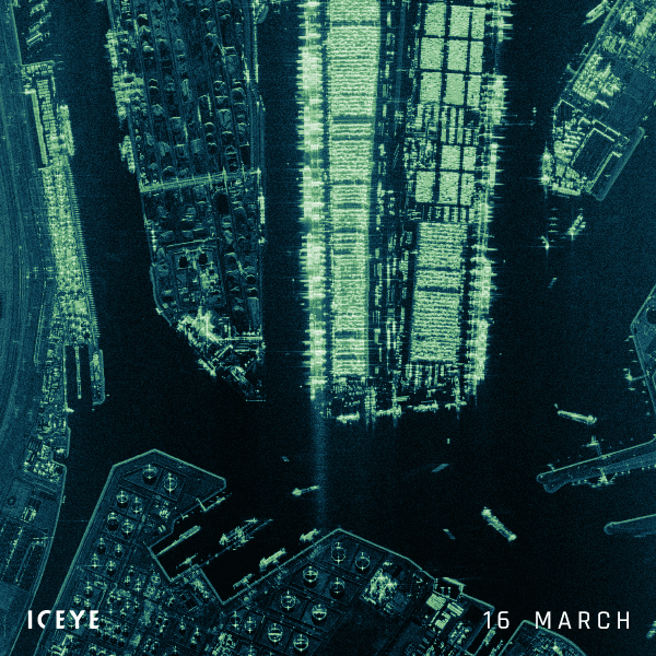
Figure 3. Port of Rotterdam imaged every day for 18 days in March 2021.
Figure 3 shows a stack of 18 images taken at exactly the same time every day for 18 days. If an object in the image hasn't moved in 18 days, then it looks exactly the same throughout the stack. This suddenly makes it very easy to identify anything that has changed from one day to the next – and importantly those areas that never change. It is easy to see ships coming and going and even which containers are being used.
Towards the bottom of the image is an oil storage area. These circular tanks have floating top roofs, so as ships arrive and depart the amount of oil in the tanks rises or falls. You can also see which oil tanks never move, which presumably has some meaning to those who know about oil supply and demand.
As well as monitoring ports and oil storage areas, having a Daily Coherent GTR capability is really useful for the monitoring of natural events, as it helps with scientific analysis.
A notable example has been the Fagradalsfjall volcano in Iceland. Volcanoes are prime candidates for SAR imaging as they are usually covered in ash clouds, which often makes optical visibility into the volcano caldera difficult and dangerous.
In Figure 4, the Fagradalsfjall volcano was monitored every day for 18 days after an eruption began. The precise imaging geometry each day reduces the effects of layover and foreshortening because each day the effects are identical. What we are left with are true changes on the ground. In this example you can see the lava pool filling up and flowing out of the caldera. On day 8 several smaller eruptions occur and on day 17 a chain of lava fountains have erupted from the ground and can be seen flowing down the hillside.
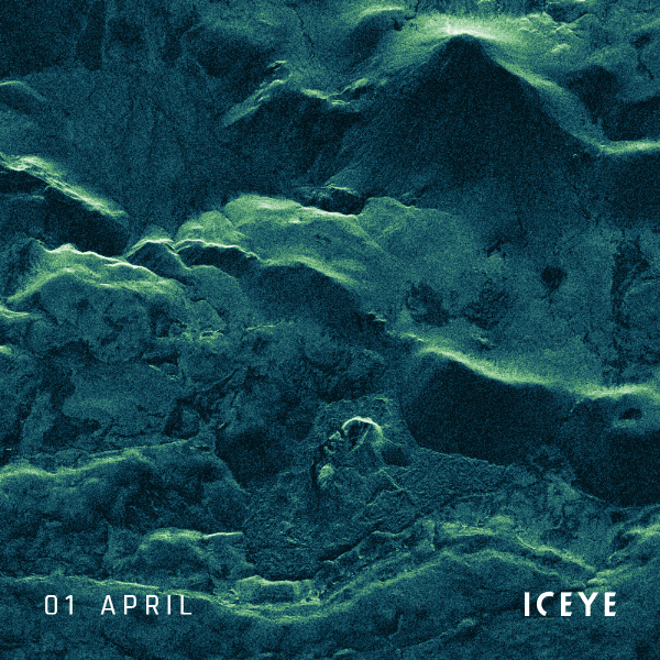
Figure 4. Fagradalsfjall volcano in Iceland over 18 days in April and May 2021. It began to erupt on the 19th of March 2021 and has been spreading lava in the area ever since.
In this post, we have presented a tantalizing glimpse of the future – where locations on the globe can be reliably and repeatedly imaged with very short times between collections. The examples shown are the first time we have been able to see events so repeatedly and reliably.
For now, the ICEYE fleet is configured and starting to provide Daily Coherent GTR images. Image time-series for commercial use will be available to order soon. In the future, there is nothing to prevent ICEYE from acquiring image stacks with 18- or even just 12-hour intervals.
Please stay tuned for future announcements. Until then, explore the unique Scan mode imagery for high revisit, wide area monitoring:
Download 


23 January 2026

06 November 2025

27 June 2025