Contact us
Get in touch with our experts to find out the possibilities daily truth data holds for your organization.

With the constantly increasing number of Earth Observation (EO) satellites, sensors, and their revisit rates, the tip and cue strategy for tracking and monitoring fast moving objects gains more and more interest. The combination of complementary image resolutions and spectral bands allow for cost-efficient and effective identification and tracking of fast-moving objects, even over large areas.
The tip and cue technique provides essential information for timely detection of irregular activities and effective situational awareness.
This technical blog gives an introduction to the tip and cue principle, discusses the advantages of using different sensor systems and presents the use case of tracking the trajectory of an iceberg based on Sentinel-1 and ICEYE SAR satellite images.
Tip and cue refers to the process of monitoring an area or an object of interest by a sensor and requesting “tipping” another complementary sensor platform to acquire “cueing” an image over the same area. Typically, the process of tip and cue is initiated with an object or location identified with a cost-effective, low resolution (but wide field-of-view) sensor. The information collected is then passed to a higher resolution (and potentially more costly) sensor for follow-up investigation and analysis.
The tip and cue process facilitates information collection about an object or an area at a variety of resolutions, timescales, and spectral characteristics over a period of time in a cost-effective manner. From a data analysis perspective, the process can reduce the amount of data collected and stored. The tip and cue process may be carried out across different types of sensors: within a satellite constellation, across different satellites, and even among ground-based or aerial platforms.
Figure 1 illustrates the concept of tip and cue process where satellite-A acquires an image over an area of interest (AOI) containing a vessel and sends this tip to satellite-B for observation. Satellite-B, after receiving the tip, monitors the same vessel taking into consideration the vessel’s trajectory as well as acquisition conditions required.
.jpg)
Figure 1. Tip and cue process between two satellites.
Leveraging sensor systems with different wavelengths and modalities for tipping and cueing has the advantage of exploiting the physical conditions of the operational environment. Optical remote sensing platforms have been used for years in numerous applications but are inherently obstructed by clouds and darkness. This is where SAR sensors excel and can complement optical sensors by providing 24/7 visibility to the monitored areas.
A tip and cue relationship between SAR and optical systems may enable global near real-time sensing of the Earth that is weather independent. Further downstream analytics may also benefit from this unique assimilation of information. Data validation and reinforcement between optical and SAR data may be used in machine-learning applications for optimizing object detection, image segmentation, and change detection analyses.
From a SAR-specific perspective, a SAR observation collected in ScanSAR mode provides extended area coverage at coarse resolution. Compared to this, Spotlight SAR observes a scene at higher resolution but with lower area coverage. Similarly, choices of different polarizations (HH, VV, HV, VH) and frequency bands (for example X-band, C-band, L-band) affect how well the radar pulses interact with material and how deep the pulses permeate into various surfaces or vegetation.
There is no one-sensor-fits-all-solution since different applications require different sensors and modalities. This is where the tip and cue process can leverage unique sensor characteristics and complement the needs of different remote sensing applications.
The success of tip and cue process from satellite-A (tipping satellite) to satellite-B (cueing satellite) depends on many factors: the time latency between satellite-A image acquisition and the time when the tipping image becomes available for analysis, the type of the object to be monitored (stationary or moving), the object trajectory estimation accuracy (if the object is nonstationary), and the respective acquisition possibilities with satellite-B.
Once satellite-A acquires the image, the earlier the tipping image becomes available for analysis after processing the better, since it helps satellite-B to carry out near real-time cueing. Once the tip is received, an AOI is defined where satellite-B shall acquire the image.
Accurately estimating the trajectory of an object with high uncertainty of its velocity is one of the most critical aspects of the tip and cue process. An object of interest to be observed by satellite can be either stationary or moving. Cueing a stationary object (or an area) is easier since the AOI does not change with time, and satellite-B only needs to consider its acquisition possibilities. For a moving object, the cueing satellite needs to consider the object’s velocity as well.
Difficulty in estimating an object's trajectory varies, depending on the object’s speed and uncertainty of the measurement of its velocity, that is, how fast the object is traveling and how often the object changes its direction of movement. For objects with high uncertainty of velocity, mapping a more precise trajectory of the object becomes critical, and there is less margin of forecasting error. For estimating an object’s trajectory, near real-time availability of external data can be useful.
The tip and cue process, if manual, requires a lot of human intervention, which causes unnecessary delays and involves the risk of human errors. With the availability of an automated tip and cue process, manual steps can be mitigated. The major requirements of an automated tip and cue process involve object detection and tracking, creating moving AOIs, and a ground segment architecture that supports acquisitions over moving AOIs.
With the envisioned ICEYE ground segment architecture and improved tasking capabilities, it shall be possible to automate the tip and cue process for near real-time, persistent monitoring of time-sensitive applications.
For time-sensitive data collection, the tip and cue process becomes invaluable. One of the examples is iceberg monitoring. The importance of frequently updated information on ice and iceberg locations cannot be overvalued. For example, in December 2020, the famous A68-A iceberg, which calved from Antarctica in 2017, was headed towards South Georgia Island and threatened the penguin colonies.
By frequently monitoring the icebergs and mapping their trajectory, vessel crews become aware of iceberg locations for operational safety and efficient route mapping. The tip and cue process can be efficiently used to persistently monitor the iceberg movement using two different SAR modes.
For an area of interest, infrequent and extended low resolution swaths can be planned to cover large areas to detect the presence of an iceberg (or icebergs). Once the iceberg is detected in the extended swath, a tip can be generated to a higher revisit sensor platform to frequently monitor the area for accurately mapping the trajectory of the iceberg. Such an efficient near real-time monitoring not only assures marine safety, but also optimizes sensor resources.
ICEYE recently demonstrated the tip and cue process for iceberg monitoring between Sentinel-1A and the ICEYE constellation, as observed in Figure 2. The iceberg was monitored in ICEYE Stripmap (SM) mode 12 hours and 38 minutes after the iceberg was imaged by Sentinel-1A in the Extra-Wide (EW) swath mode.
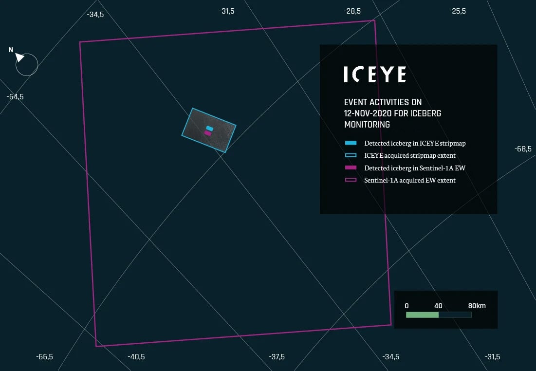
Figure 2. Event activities for the iceberg monitoring near Antarctica by Sentinel-1A EW and ICEYE SM, acquired approx. 12.5 hours apart on 12th of November 2020.
Figure 3 shows the detected iceberg in ICEYE Stripmap. With high-resolution X-band ICEYE imagery, one can clearly observe not only the (bigger) iceberg but also small icebergs and drift ice. One can also clearly observe the traversed path of the iceberg through the drift ice. Such fine details help to better understand the drift behavior of the iceberg and estimate its velocity. The iceberg size as observed in ICEYE imagery approximates to 16 km2.
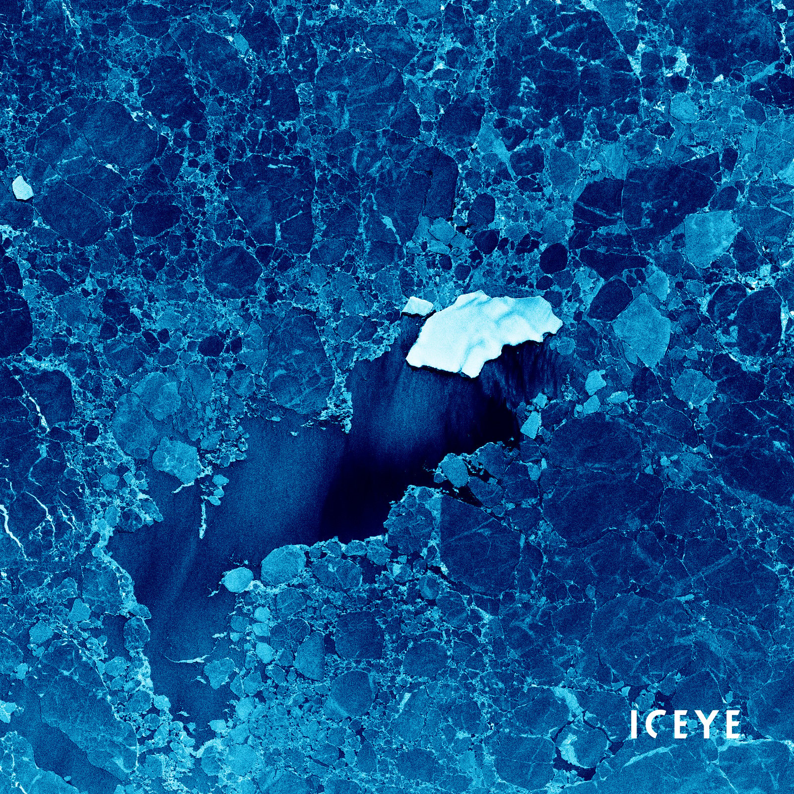
Figure 3. Iceberg detected in ICEYE Stripmap image acquired on 12th of November 2020 (18:53:26 UTC).
ICEYE SAR imagery is a valuable source for the tip and cue process. The ICEYE satellite constellation delivers reliable, high-resolution imagery at any point on Earth, regardless of daytime or cloud coverage, which makes it complementary to optical and lower-resolution sensors. The high-revisit rate guarantees timely information and enables effective analysis of near real-time events.
ESA sponsors free access to ICEYE SAR data which is available through ESA's Third Party Mission (TPM) program. This opportunity is relevant for universities, research entities, and commercial companies. Read more and submit your request to ESA to access new and archived high-resolution ICEYE SAR data of the locations of your interest.


23 January 2026

06 November 2025

27 June 2025