Contact us
Get in touch with our experts to find out the possibilities daily truth data holds for your organization.


With the ability to see through clouds and darkness, Synthetic Aperture Radar (SAR) satellite monitoring by ICEYE can deliver a forensic level of detail on any location on Earth, around the clock. This persistent monitoring makes it possible to detect physical changes, such as the movement of ships or aircraft, quickly and accurately.
What’s more, combining SAR with other satellite imaging technologies has the potential to provide even more advanced, actionable intelligence that is essential for rapidly evolving defense operations. ICEYE’s collaboration with BAE Systems is a prime example of next-level space-based intelligence.
We are supplying BAE Systems with advanced SAR technology as part of their new multi-sensor satellite cluster known as Azalea™. This group of Earth sensing satellites will use a range of instruments to collect radar, visual and radio frequency (RF) data. Machine learning and edge processing will be used to analyze and quickly deliver the resulting intelligence to tactical or strategic users anywhere in the world, directly from low earth orbit.
Our initial contract covers the supply of SAR capability through a dedicated service for the Azalea cluster’s demonstrator mission. ICEYE is uniquely positioned to offer dedicated satellite capacity through an annually renewable contract, without the burden of ownership.
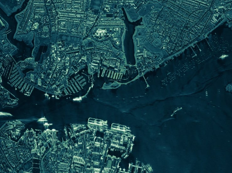
Figure 1. ICEYE's very high resolutions image of the Portsmouth Naval Base, United Kingdom, with 2 Queen Elizabeth II-class aircraft carriers at a dock
“Getting the right intelligence into the hands of the people who need it most is core to Azalea’s mission. Space-based data will play a key role in the future battlespace – whether for informing strategic command, alerting an in-area warship, or providing real-time intelligence to forces on the ground. ICEYE’s technology will help Azalea deliver unparalleled visibility to customers across all domains,” says Elizabeth Seward, Head of Space Strategy & Future Business, BAE Systems Digital Intelligence.
The Azalea cluster will contain four satellites that between them deliver SAR, optical, RF signals and analysis. The cluster will provide high assurance security and resilience through inter-craft space links and allow for the simultaneous execution of multiple customer applications through a fully re-configurable system.
“By harnessing SAR, customers will have persistent intelligence of their targets, day or night, regardless of weather conditions. The data of SAR imaging will give an additional layer of intelligence providing a powerful combination with the other sensors,” says Damon Olloman, Head of Missions for ICEYE.
Bringing various types of satellite imaging technologies under the operational control of one company, like BAE Systems, means better intelligence delivered quicker than ever.
As a strategic investor in ICEYE since 2022, BAE has recognized the potential of SAR satellite technology and the capabilities that ICEYE can offer to the military intelligence sector. The Azalea cluster demonstrates how SAR can be utilized in multi-sensor data collection, paving the way for more advanced, reliable, and timely intelligence in defense operations.
“SAR technology was initially invented and used for military purposes. Since then the use of SAR has spread across many civilian sectors, but defence use represents currently by far the largest segment. With the Earth watchable 24/7, Azalea will prove that diverse defense remote sensing requirements can be satisfied by commercial capabilities,” says Jouni Kytömaa, Senior Vice President, Satellite Missions Line of Business.
Application study
Download our Application Study to learn how to use ICEYE SAR data to counteract illegal human trafficking and smuggling in your maritime borders.

03 June 2026

23 January 2026

06 November 2025