Contact us
Get in touch with our experts to find out the possibilities daily truth data holds for your organization.

Very high resolution (VHR) images tend to have small coverage due to technical data acquisition constraints. But what if you need to observe a large area and look for small objects and details? Well, then you have a dilemma. You can choose either VHR satellite imagery or imagery covering large areas at a lower resolution. Now, you no longer need to compromise.
ICEYE has developed a novel solution that fills this gap in the market: the Spot Extended Area image. It's yet another pioneering step on our journey to continuously enhance our persistent monitoring and change detection capabilities and adapt them to different needs.
Sure, there are various satellite imaging modes with various image resolutions available on the Earth observation market. But because of sensor limitations, the general rule has always been this: the higher the resolution, the smaller the covered area.
This mainly becomes an issue when small patterns and objects need to be detected and tracked. VHR imagery typically has a footprint of only a few kilometers in either direction. This relation is shown here in Table 1 using ICEYE's standard imagery modes and illustrated in Figure 1.
| Parameters | Spot | Strip | Scan |
| Scene Size: azimuth [km] x range [km] | 5 x 5 | 30 x 50 | 100 x 100 |
| Ground Resolution: az [m] x rg [m] | 1 x 1 | 3 x 3 | 15 x 15 |
Table 1. ICEYE SAR imaging mode parameters. For more information, read the SAR Product Guide.
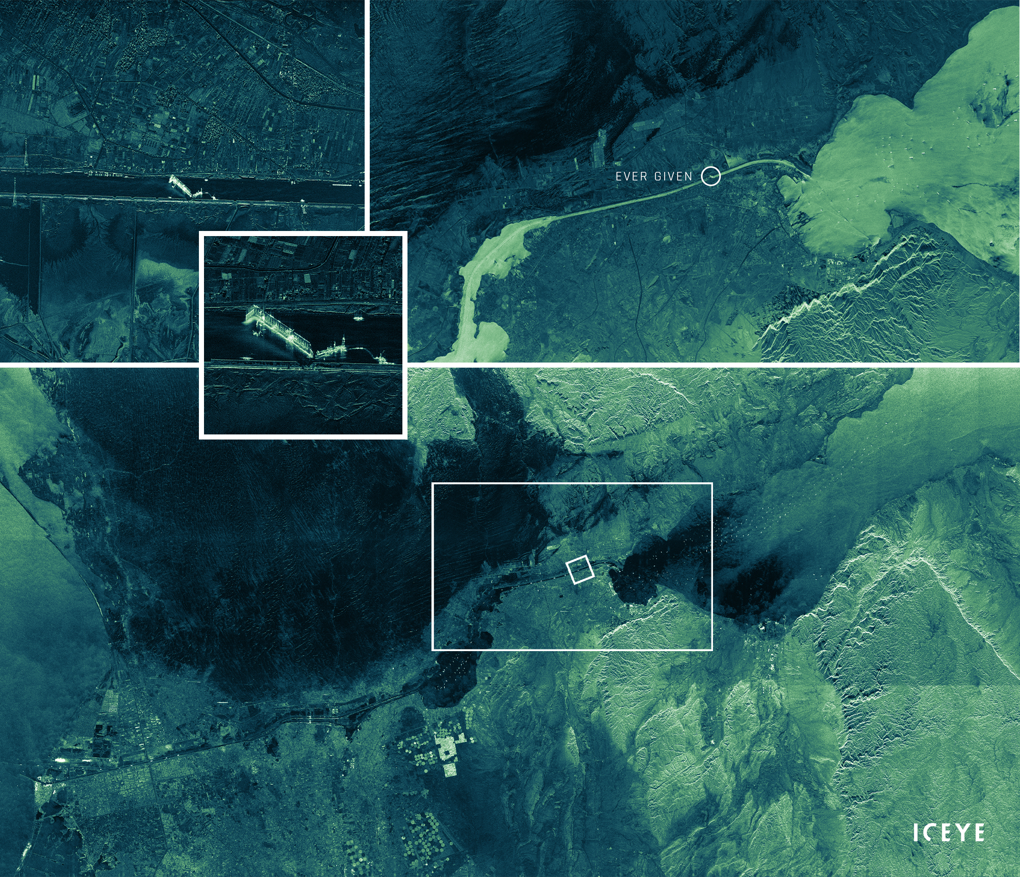
Figure 1. Examples of different imaging modes and resolutions: Spot mode (upper left, with zoom-in), Strip mode (upper right), and Scan mode (bottom) imagery showing the Suez Canal when the container vessel Ever Given blocked the passage (March 2021).
As the world’s first commercial SAR data provider, ICEYE took up the challenge and succeeded in combining very high resolution with a large scene size, thanks to the versatility of our flat antenna design.
The ability to deliver a VHR SAR image covering a large area is a major breakthrough in SAR imagery technology. ICEYE’s Spot Extended Area image provides the same ground resolution of 1-meter as the standard Spot image, but with nine times the coverage. With a scene size of 15 km x 15 km, it is the world’s largest VHR SAR imagery.
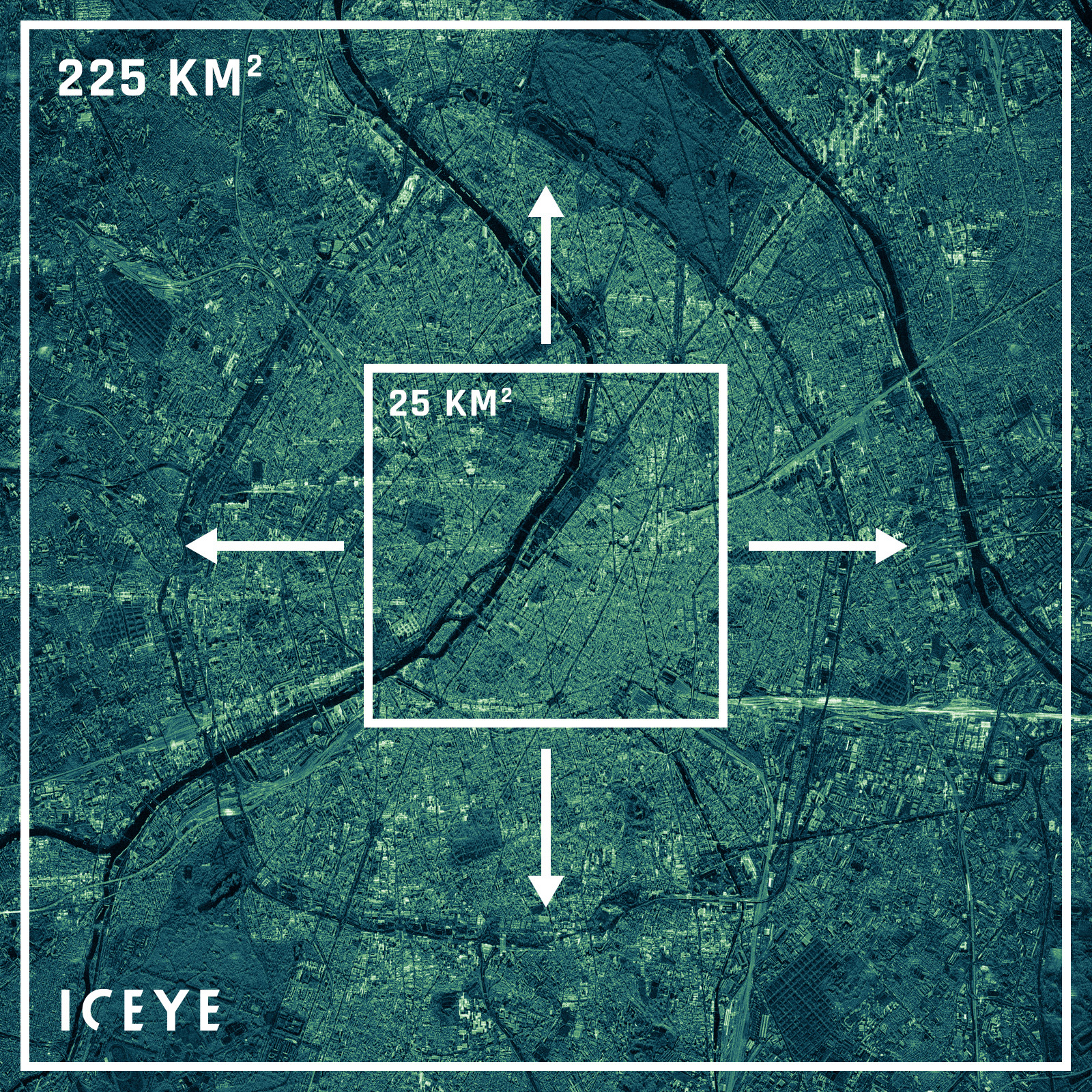
Figure 2. Coverage comparison of ICEYE's standard Spot and the new Spot Extended Area imagery at the same ground resolution. The example shows Paris, France.
It's worth noting that the Spot Extended Area imagery does have a slightly lower azimuth resolution in slant geometry and less looks than the Spot imagery. Those working with Single Look Complex (SLC) data should keep this in mind. However, the slant resolution in range, incidence angles and the noise equivalent sigma-zero are all identical.
For a better overview, Table 2 compares the parameters of ICEYE’s SAR Spot imagery and Spot Extended Area imagery.
| Parameters | Spot | Spot Extended Area |
| Scene Size: az [km] x rg [km] | 5 x 5 | 15 x 15 |
| Slant Resolution: az [m] x rg [m] | 0.25 x 0.5 | 1 x 0.5 |
| Ground Resolution: az [m] x rg [m] | 1 x 1 | |
| Looks: az x rg | 1-4 x 1-2 | 1 x 1-2 |
| Noise Equivalent Sigma-Zero [dBm2/m2] | -18 to -15 | |
| Performant Incidence Range [°] | 20-35 | |
Table 2. ICEYE SAR Spot and Spot Extended Area imaging parameters. For more information, read the SAR Product Guide.
The availability of a Spot image with 9 times the scene size is a huge advantage for all pattern-of-life observation and surveillance activities, especially for single-object detection and tracking. The large image coverage provides context in particular situations, which helps hugely in enhancing decision making and the planning of further steps and actions.
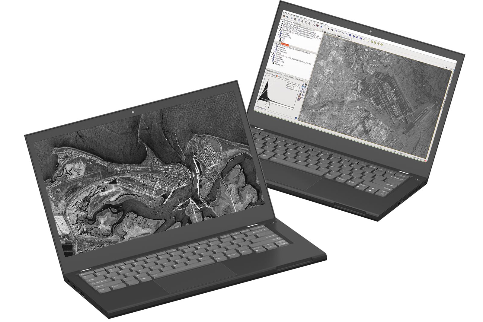
Figure 3 impressively illustrates the difference between the standard Spot image scene size and the new Spot Extended Area. It puts the observed area in perspective and gives you a better analysis and understanding of the situation. This enhanced situational awareness also helps in the prediction of potential future events in the area.
Using alternative VHR image products would require multiple satellite passes to cover an area that you can now capture with just one single Spot Extended Area image.
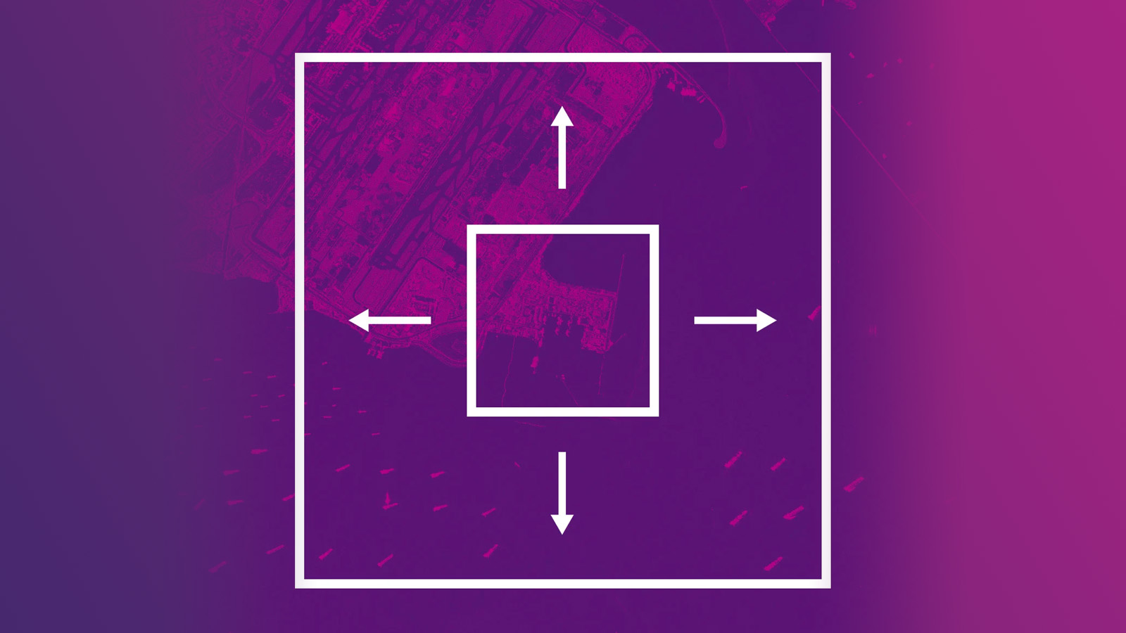
Figure 3. Comparison of the coverage and resolution of Spot and Spot Extended Area. The image shows Changi Airport, Singapore, and vessels in the vicinity.
Spot Extended Area imagery also enables the acquisition of information over multiple, clustered areas with a single satellite pass. It allows highly accurate, highly reliable monitoring of many small areas next to each other.
Other data sources on the market would have to cover each area separately in a single satellite pass. And that means those images could only be acquired sequentially and not simultaneously, making it impossible to gain accurate insight into what's happening in these areas at a certain point in time.
And thanks to ICEYE’s large satellite constellation, these adjacent areas can be imaged even multiple times a day if needed - a revolutionary revisit rate not offered elsewhere in the market.
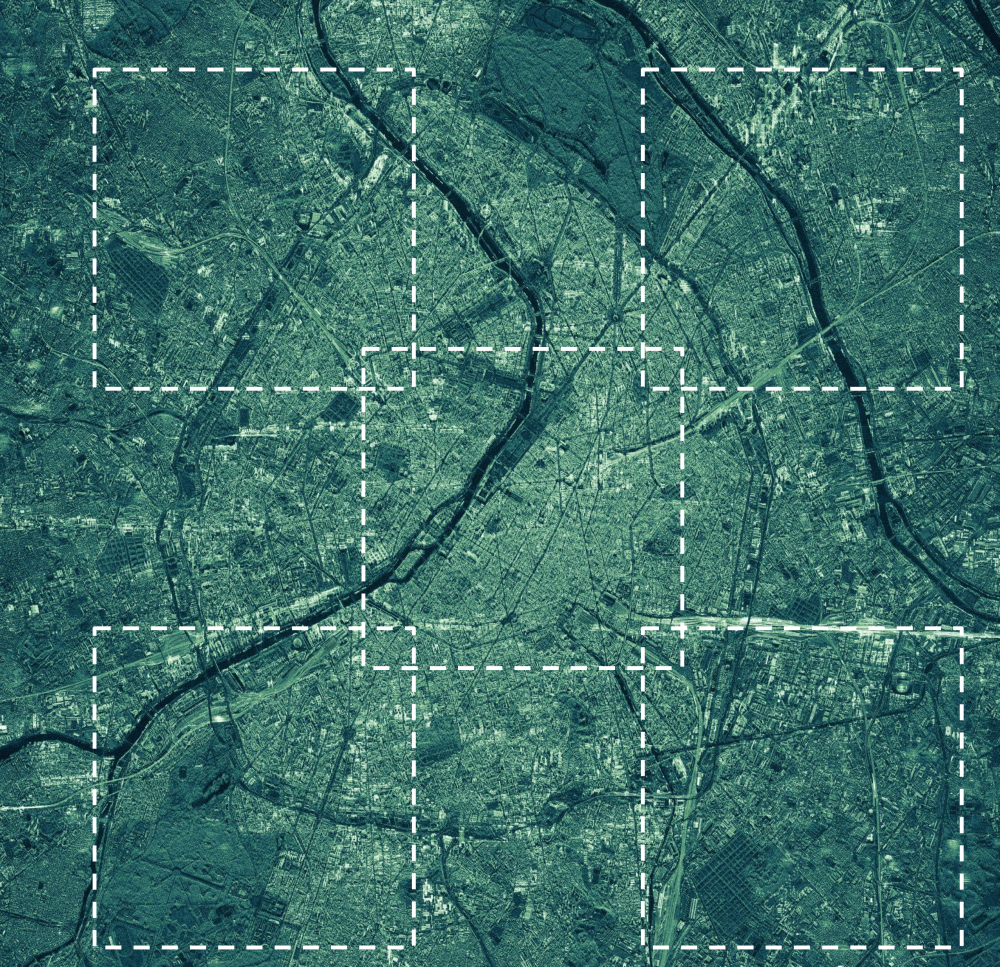
Figure 4. Acquisitions of multiple, clustered areas at the same time with a single satellite pass in one image.
ICEYE is constantly working to maximise scene sizes for all imagery modes to enhance Earth observation applications and enable the delivery of detailed, real-time information for pattern-of-life analyses, local disaster prevention and mitigation, and the perils threatening humanity.
Explore the quality and enlarged information content of this Spot Extended Area imagery to see how it can enhance your monitoring applications.
Download the 


03 June 2026

23 January 2026

06 November 2025