Contact us
Get in touch with our experts to find out the possibilities daily truth data holds for your organization.


Since late October, the Reykjanes Peninsula has experienced tens of thousands of earthquakes, a common precursor to volcanic activity. On October 25th, 2023, over 700 earthquakes were reported in the area, echoing a similar seismic event in July 2023 that led to a volcanic eruption.
ICEYE began monitoring these activities by tasking coherent pairs with a short time interval. This approach allows for the detection of subtle ground deformations using Interferometric Synthetic Aperture Radar (InSAR). As of November 17th, the collection of coherent imagery of this region is still ongoing.
The results of our InSAR analysis and interferometric pairs have been sourced to the Icelandic Met Office. Their expert team used the data to measure and map the ground deformation in the peninsula. Such deformation maps – created frequently from coherent pairs with a short time interval – help to identify the driving mechanism for ongoing seismicity and, combined with other data such as GNSS displacements, can help to model the potential magma motion.
A deformation map generated from ICEYE's interferometric pair by the Icelandic Met Office. Source: Michael Wollersheim, Director of Analytics at ICEYE, on LinkedIn.
In the current situation, the speed of data processing is key. Authorities need access to updated deformation maps before the dyke formation and actual eruption to be able to warn the residents and plan the evacuation process.
“It seems that insights from seismic sensors and GPS only give clues and indications of what may occur. But to really see the whole picture, our InSAR data plays a key role,” said Valentyn Tolpekin, Senior Remote Sensing Engineer at ICEYE. “Fortunately, our rapid data can be relied upon for a fast-developing event like this, where things can change constantly.”
Our analysis reveals the progression of ground deformation patterns over the last few weeks. The sequence includes a swarm of earthquakes, a period of uplift, a series of stronger earthquakes, and a distinct deformation pattern, accompanied by the first signs of magma intrusion on November 10th. This shows that the magma moved to a shallower depth within the Earth's crust, significantly raising the likelihood of an eruption.
This interferogram, generated from SAR Interferometry of coherent pairs of images, reveals the pattern, location, and measurements of ground displacement between November 10th and 11th. Applying phase unwrapping to this interferogram, we can observe that the ground has subsided up to 39 cm and uplifted by up to 12 cm (excluding the decorrelated area), in the satellite line of sight direction.
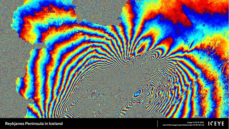
Figure 1. An interferogram, generated using two coherent SAR images from ICEYE.
One of the latest interferograms from November 14th points to a smaller deformation magnitude and a more localized area near Grindavík. This indicates that the impact will likely be confined to this smaller area.
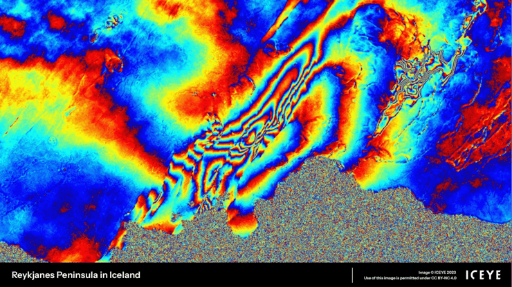
Figure 2. An interferogram, generated using two coherent SAR images from ICEYE.
On November 12th, the Icelandic government declared a state of emergency and ordered the evacuation of Grindavík. Nevertheless, the movement of magma under the surface is hard to predict, so it is essential to continue monitoring the deformation in this area for the coming days.
As the situation develops, ICEYE is committed to supporting governments, local authorities, and communities with SAR data. Our InSAR capability is currently in R&D as we explore new ways to provide timely and accurate Earth observation insights. For more frequent updates on the seismic activities in the Reykjanes Peninsula, check the Icelandic Met Office website.

03 June 2026

23 January 2026

06 November 2025