Contact us
Get in touch with our experts to find out the possibilities daily truth data holds for your organization.

Financial service providers worldwide are in need of advanced tools with which they can secure their investments in agriculture.
In developed countries, governments and public administration organizations seek reliable and cost-efficient data sources to validate farmers’ reports on their farming activities.
In developing countries, the lack of transparency and reliable control processes which could ensure the farmer’s compliance with agreements and responsibilities, and also the high-risk nature of agricultural lending may hinder agricultural investments by financial organizations. Thus, new solutions for compliance monitoring and trust building between parties involved are needed to enable and boost agricultural financing.
Frequent monitoring from space can make agricultural financing processes more transparent and assist the various parties involved in the processes in achieving their goals. Persistent crop and harvest monitoring can be improved with the use of radar satellites.
In 2017, the agriculture sector contributed 4% to global GDP. It was estimated that food demand will increase by 70% by the year 2050, implying that a minimum investment of $80 billion would be required to meet the demand for yearly agricultural production.
However, there is a lack of agricultural financing and insurances in developed and particularly in developing regions around the world, as stated by the World Bank and FAO (Food and Agriculture Organization of the United Nations). According to these entities, the total credit to agriculture on a global scale only accounts for 2.9% in the loan portfolios of financial service providers, still much lower than the contribution of agriculture to GDP.
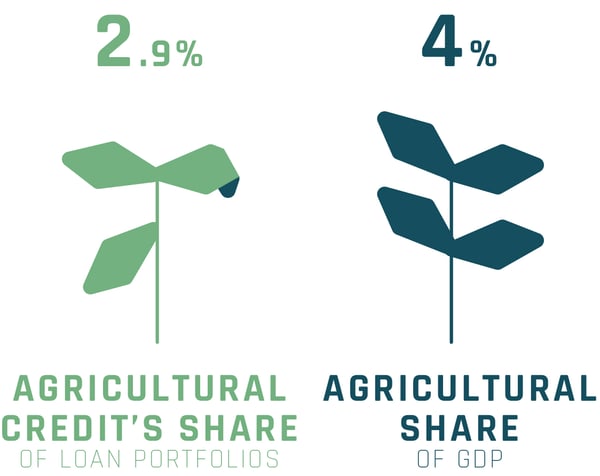
“Globally, the total credit to agriculture disbursed by commercial banks operating in the countries increased from 2.4% in 2016 to 2.9% in 2017. Given that the agriculture sector globally contributed over 4% of Gross Domestic Product (GDP), it appears that agricultural producers face a negative bias in access to credit.” – FAO.
It would appear that a lack of trust, among other causes, remains a huge challenge for governments, agrochemical companies and financial service providers who refrain from investing in agriculture, especially in developing countries..
Limited access to reliable information on crop conditions can also be a barrier for building trust between financial service providers and farmers. For example, financing organizations working in the agriculture industry require timely information on actual crop growth status, crop yield, health, and damage to ensure the correct use of agricultural loans, subsidies or other financing solutions provided to farmers.
However, access to such information that supports risk management is mostly either limited or inadequate, and the volume of information might be insufficient.
Satellite images have been utilized in agricultural financing for a long time. However, the volume and availability of the kind of satellite data that is suitable for agricultural applications might be insufficient, and access to it can be limited. Optical satellite imagery is affected by cloud cover and daylight conditions, which makes it harder to persistently monitor areas of interest.
Radar sensors, however, are capable of penetrating clouds and acquiring images in limited daylight conditions. This is why radar satellites can be used for continuous and reliable monitoring of vast agricultural land areas at any time of day.
Accurate information about crop conditions and harvest events can be revealed with persistent radar satellite monitoring. Using frequently acquired radar images, it is possible to check whether selected fields have been recently harvested, if the farms are being actively maintained, or if the crop has been damaged by floods – as example insights gained from orbit.
Frequent monitoring of croplands enables financiers make precise assessments, to then manage their risks on their loans. With actionable radar satellite data, lenders can understand the past and present better, and ultimately, make valuable predictions on farming activities relevant to them.
To summarize, information derived from persistent agricultural land monitoring, done with radar imaging satellites, is a useful financing control and risk management tool. It can be used to provide frequent updates on land use and farming activities. The derived information enables better insights for fact-based decision-making, while building trust between the various parties involved.
For developing countries, accurate information derived from radar satellite imagery provides a solid basis for building trust between farmers and operators in the agricultural finance and insurance industries. Currently it is not viable to reliably monitor the use of large and remote field areas without expensive ground-based control. Visits to the fields are time-consuming and require a large number of trained employees. Frequent monitoring with radar satellites can make the process faster, more accurate and more transparent.
For developed countries, or larger bodies such as the EU, reliable and frequent radar satellite data on agricultural land use can be utilized for highly effective control over the agricultural subsidies funded by governments or other public sector entities. Governments can rely on radar satellite data to determine, for instance, if individual fields have been cultivated as stated in the farmers’ applications for further financial support. The possibility to manage and even automatically monitor land use with radar satellite data translates to significant savings, and it enables the development of new kinds of agricultural services.
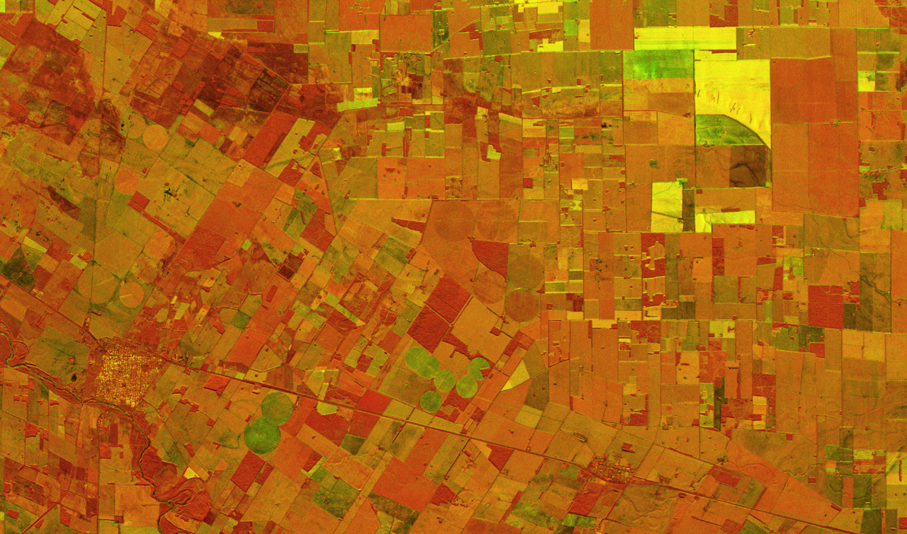
Change detection: combination of two radar satellite images near Córdoba, Argentina, taken with the ICEYE SAR satellite constellation.
ICEYE provides timely and reliable data with its growing SAR satellite constellation, with customized solutions to help boost agricultural financing and improve control processes. Field-specific information on cultivated land areas can be delivered regularly and frequently: day and night, irrespective of weather conditions or cloud coverage.
Explore further:
Persistent Agricultural Land Monitoring with Daily Radar Satellite Data (PDF).


03 June 2026

23 January 2026

06 November 2025