Contact us
Get in touch with our experts to find out the possibilities daily truth data holds for your organization.


It’s an interesting idea. Traditional imaging acquisitions are based on capturing a single image per imaging activity, as the satellite flies by a geographic region - one pass over a region, one image.
But, what if we can increase the capacity of the satellites by 10x using just software?
Turns out we can - using existing hardware capabilities to supercharge our imaging capacity and take five images per imaging activity. Or 10. Or 20. Or more. And then repeat this, over and over again as the satellite orbits around the globe, charging and chilling in space.
It sounds unbelievable - but that’s exactly what we’ve experimented with, tested, and deployed across all generations of ICEYE satellites in our fleet to offer enhanced, flexible and efficient imaging capture capabilities for our customers.
Here’s how.
The short answer is: a lot.
Let’s dig into the long answer (because when was the last time a short answer was enough anyway?).
The benefit of small SAR satellites is that they are agile and quick to maneuver, enabling them to cover the next geographical region immediately after collecting the last radar pulse over the previous region — demonstrating true region-to-region agility.
The capability relies on asynchronous satellite software taking many imaging acquisitions back-to-back and maneuvering the attitude determination and control system (ADCS) between those acquisitions. ADCS is an important satellite subsystem that uses sensors to determine and control its orientation in space. By orienting the ADCS as fast as possible to the next location, ICEYE satellites can capture multiple imaging acquisitions hundreds of kilometers apart.
Also, let's not forget our satellites’ radar beam steering capabilities, powered by phased array antennas. In a nutshell, by physically pointing our antenna at a central location within the larger region, we can apply pulse-by-pulse phase corrections to multiplex individual locations into one coherent data collection. Within a span of 50 microseconds, our radar can begin pointing to another location inside the region and collect pulses—enabling the capture of multiple images in a single pass over a region.
This intra-region superpower is explained by Darren Muff in the Beyond the Echo - Phased array with small satellites blog post.
While intra-region capability acquires images via aperture sharing, region-to-region takes real, full aperture SAR images.
Combine the physical maneuver and the electronic beam steering capability, sprinkle it with optimized acquisition and constellation planning, suddenly capturing hundreds and hundreds of images during the time the satellite goes around the Earth becomes incredibly easy with one satellite. Add tens of satellites in the fleet and we are moving quickly into a world with thousands of images per day.
The outcome is an unprecedented capability to capture as many as 20 images in a single imaging acquisition and then repeat, as needed. Take a look at Figure 1, three imaging acquisitions with 33 images in total, all captured during an ascending pass in a single imaging activity; a beautiful heart over the southeast coast; a single image over red sand dune fields in central Australia; and a trail of several images in the northern part of the continent.
 Figure 1.
Even though a single satellite can capture numerous images, there are limits to it — especially in highly congested regions. That’s where a constellation of satellites truly shine, stepping in to provide the additional coverage and flexibility needed to meet the demand.
In the animation below (Figure 2), two satellites are flying close by, both imaging as they descend in orbit. The first satellite, while passing over Egypt, captures a series of six images of the Red Sea mountains (Figure 2a). Next, it gets ready to capture two more acquisitions in central Saudi Arabia (Figure 2b). Meanwhile, a second satellite in the fleet is busy collecting 20 images over the Mecca-Jeddah region (Figure 2c) – an area the first satellite simply couldn’t cover, since it was still maneuvering towards its next acquisition. This teamwork means no spot gets missed, even in the busiest regions.
 Figure 2.
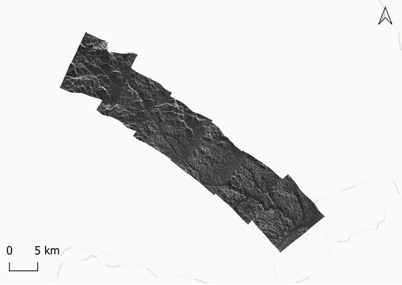
Figure 2a. The first satellite captures a series of six images.
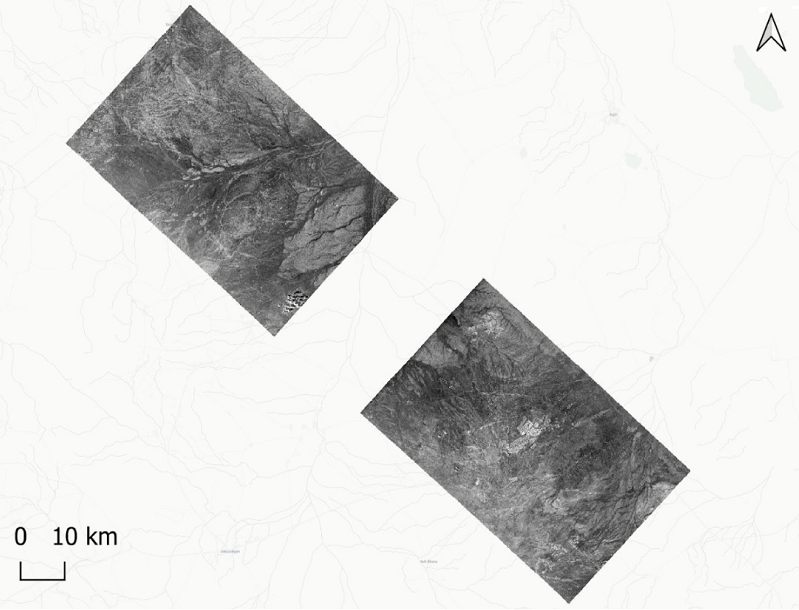
Figure 2b. Next, it captures two more images.
Figure 2c. While the second satellite is busy collecting 20 images.
This is one of my favorite questions. Why bother taking as many images as quickly as we can?
SAR is an incredibly helpful tool in Earth Observation, thanks to its ability to see through darkness and cloud cover. While this provides a relatively fast way to gather information about what’s happening on the ground, it still takes multiple orbits for a single satellite to build up a comprehensive picture of what’s happening in a specific region of interest. In today’s increasingly dynamic geopolitical landscape, latency is the new resolution. Operating a fleet of satellites, fits right in, providing the necessary coverage and revisit times for actionable insights. It gives ultimate flexibility for persistent monitoring of the Earth.
A scientific research customer might want many images of the same location to monitor changes in the natural environment, while a defense and intelligence customer might be looking for multiple images over a wider region while assessing national security. Rather than capturing these images over multiple passes over the region, we can take these images during a single pass over the region or back-to-back acquisitions in adjacent regions, and then repeat as necessary.
Thanks to our agile flight software, these capabilities have already been deployed to ICEYE’s own fleet for our data customers, and are available for ICEYE customer missions.
It’s fair to say, though - we’ve come a long way from traditional SAR imaging modes and corresponding imaging capacity with one pass over a region, one image. ICEYE’s ability to innovate at an order of magnitudes, both in hardware and software at the scale of building and operating multiple fleets is unprecedented.

25 June 2026

22 June 2026

03 June 2026