Contact us
Get in touch with our experts to find out the possibilities daily truth data holds for your organization.



Earlier in this series, we looked at the roles that planning and flight software play in getting insights to customers more quickly.
Once the satellite has captured and downlinked the data, a new challenge begins: turning raw radar echoes into an image users can interpret and understand.
Processing SAR information used to take significant time, particularly for very high resolution imaging modes. Finding ways to reduce latency at this stage has therefore been a major focus for ICEYE.
In this blog post, we take a closer look at:
Why some SAR images take longer to process than others
How intelligent software removes unnecessary delays from the processing pipeline
How advances in algorithms and processing techniques reduce image formation times
Why reducing processing latency starts long before image formation begins
The raw radar pulses are downlinked from the satellite to a ground station. They also need to be combined with precise GNSS positioning and timing data, so the system knows exactly where the satellite was when the data was being collected.
From there, processing happens in two separate stages.
The first stage is image formation (also called focusing). Our ground processors are specialized software systems that use SAR algorithms to turn raw radar echoes into a focused image. We don’t use a single processor for everything. One is built for wide-area modes such as Strip and Scan, where coverage and predictable runtimes matter most. Another is optimized for speed on high-resolution Spot and Dwell imagery. A third is kept for cases where maximum image fidelity matters more than turnaround time.
Every processor writes its output to the same intermediate format, whichever one forms the image. This internal handoff defines exactly what a focused image looks like before it becomes a customer product. As a result, we can change or improve the processor behind an acquisition without changing what customers receive.
The second stage is product generation. A dedicated component takes the focused image in that common format and writes out every customer data product. It applies the same packaging and metadata whichever processor formed the image.
The two primary products are:
Amplitude-only images (Ground Range Detected, GRD) strip away the phase data and are projected from slant range to ground range, which makes them easier to interpret and to load into user systems. They are usually multi-looked, which reduces speckle noise.
Processing time depends mainly on two things: how much raw SAR data was collected, and how difficult the acquisition geometry is to focus. Both vary a lot from one image to the next.
The amount of data is set largely by the imaging mode and the geometry. Higher resolution needs more radar bandwidth and a longer synthetic aperture, which means more pulses to process. Wide-area modes such as Strip and Scan cover large areas at coarser resolution (Figure 1 ). That means less data per square kilometer, and they can be focused with efficient frequency-domain algorithms, so they usually process quickly.
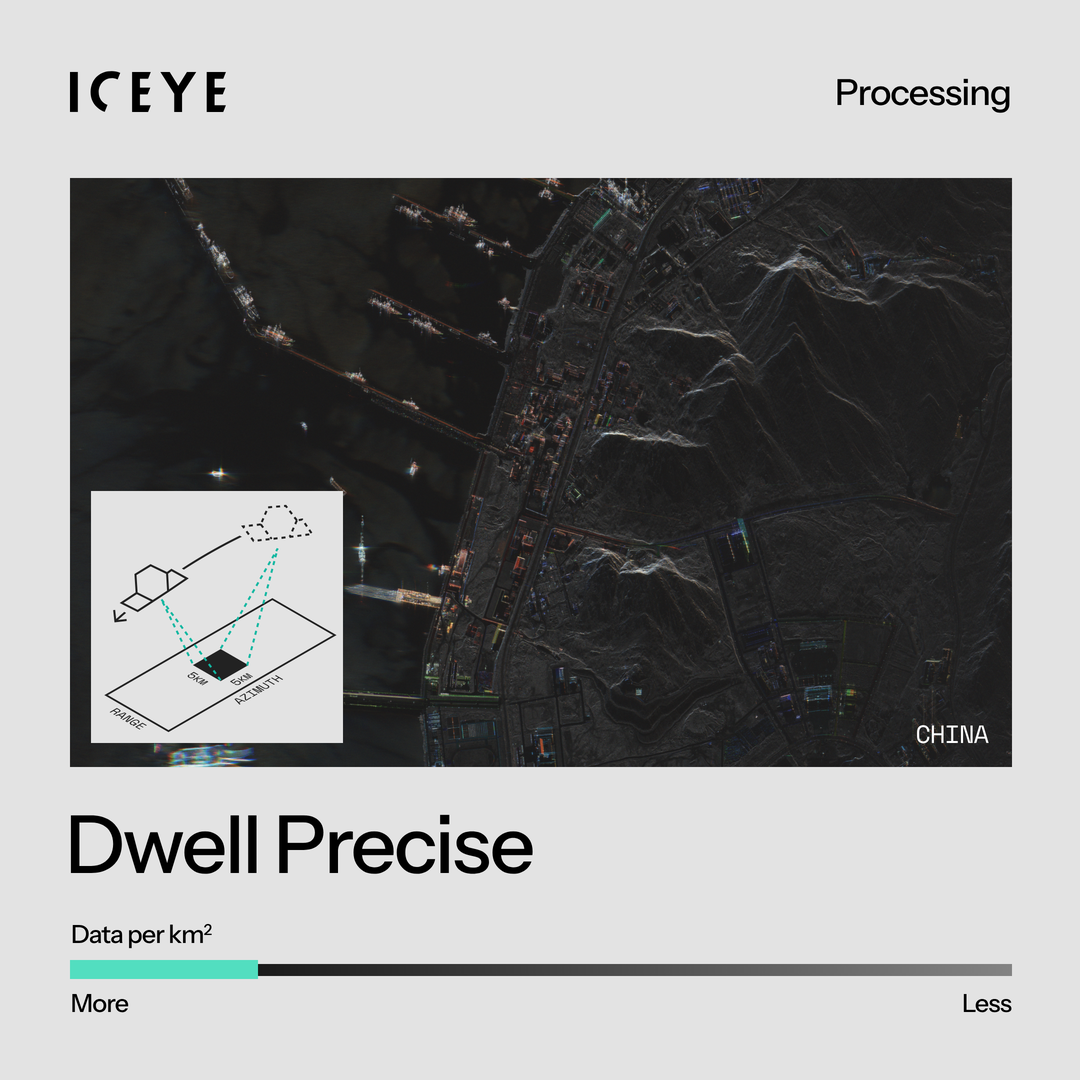
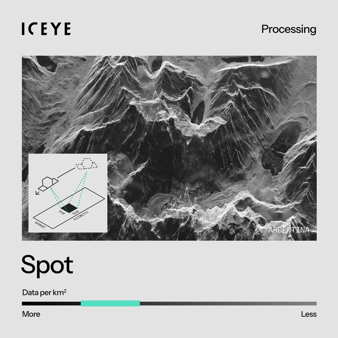
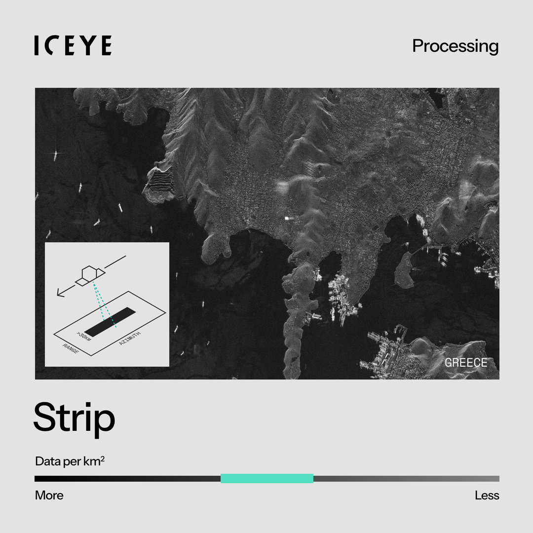
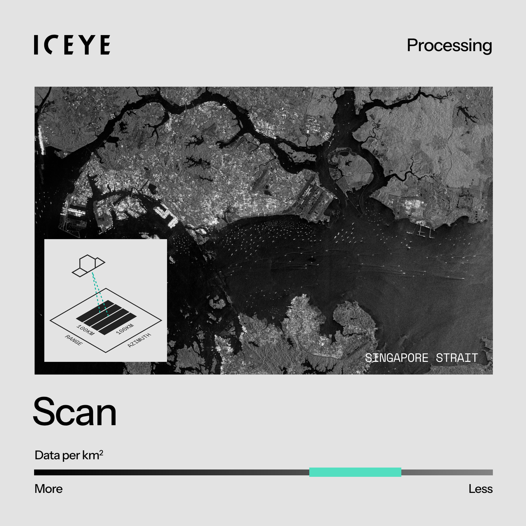
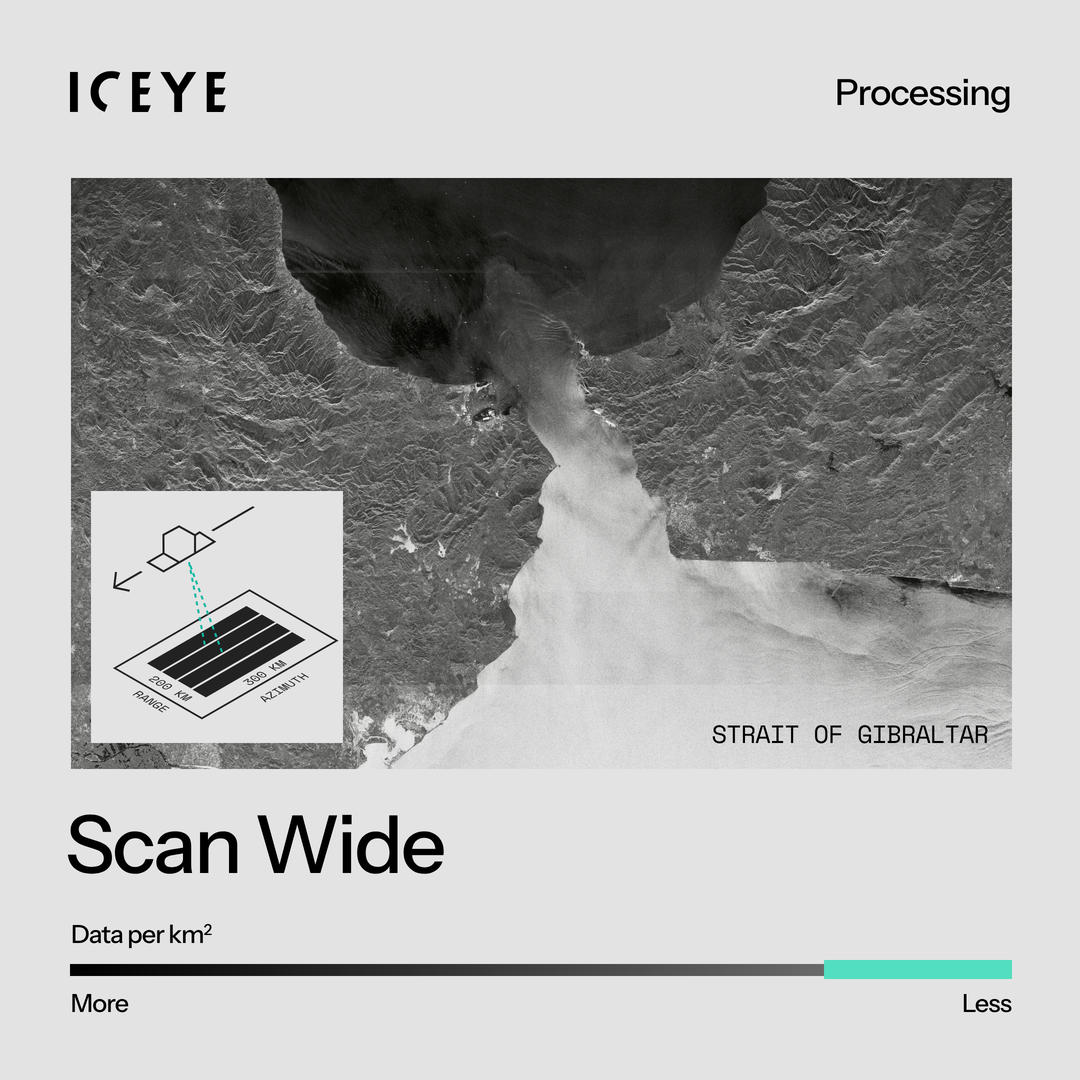
Figure 1. Higher-resolution imaging modes such as Dwell Precise and Spot need more radar bandwidth and longer synthetic aperture, which means more pulses to process. Wide-area modes such as Strip and Scan cover large areas at coarser resolution, which means less data per square kilometer and quicker processing times.
Imaging geometry matters just as much. When a target is imaged at a steep squint (the satellite is far ahead of or behind it) or at a high incidence angle (far off to the side), the satellite’s viewing angle to the target changes more slowly.
Reaching the same resolution therefore takes a longer collection and more pulses. These geometries also stretch the assumptions that the fastest image-formation algorithms rely on, so they need extra corrections or more general, more computationally intensive algorithms. As a result, a squinted high-resolution spotlight image can take considerably longer to process than a broadside image of the same target.
Reducing processing time therefore comes down to two things:
Making the image formation more efficient: better algorithms, choosing the right algorithm for each acquisition, improved software, and better use of computing resources.
Collecting and processing only the data that is actually needed, starting at the planning stage.
Below, we look at several recent innovations that have reduced latency by addressing both sides of the equation.
Every SAR image is built from thousands of radar pulses transmitted and received by the satellite. After downlink, these pulses must be decrypted, reassembled into a complete acquisition, and split into the individual images that will be processed. In an ideal world, every pulse would arrive perfectly. In practice, small amounts of data are regularly lost or corrupted during downlink, and the data for a single acquisition can arrive in pieces across several transfers.
Not every pulse is needed to produce a high-quality image. But knowing whether you have enough of the right data is not a trivial problem. Different imaging modes have different requirements, and not every missing pulse has the same impact on image quality. The safest approach would be to wait until every missing pulse has been recovered, but that can mean waiting for the satellite’s next ground station contact and adding tens of minutes of latency.
To avoid that, every acquisition now passes through an automated quality gate, in our cloud processing and in on-premise deployments alike. The gate checks the pulses received and predicts whether the resulting image will meet the product specification. If it will, processing starts immediately, even if some pulses are missing. If the missing data would affect image quality, the system holds the image, picks up the recovered data from a later downlink, and starts processing as soon as it arrives.
We have also been steadily shortening the steps around that gate. A new, faster service now handles decoding and decrypting the downlinked data. Rebuilding the software that splits an acquisition into individual images has made that step up to 15 times faster, taking it from minutes to seconds.
Finally, we are reducing the time it takes to get computing resources ready. In a cloud environment, a processing job may first have to wait for suitable computing resources to start and for the processing software to load. By assigning each type of job to the right pool of machines, keeping capacity ready for time-critical work, and slimming down what has to be loaded before processing can begin, we are cutting this start-up overhead so that image formation can begin almost as soon as the data is ready.
Having enough radar pulses is only part of the picture. To form a SAR image, the processor also needs to know exactly where the satellite was when each pulse was transmitted and received.
Traditionally, this orbit information has followed a separate workflow from the image data itself. After the raw SAR data is downlinked, the processor has to wait for satellite telemetry to be downloaded, processed by another system, and made available through an API. While this approach provides extremely precise orbit information, it also introduces additional latency.
To remove that bottleneck, we have developed a software capability which enables the orbit metadata to be included within the image payload. The processor can use this information to build a highly accurate model of the satellite's position throughout the image acquisition, meaning processing can begin as soon as downlink is complete.
Once the data has been assembled, it has to be focused into an image. This is where the heavy SAR mathematics happens: range compression, correcting for the constantly changing distance between satellite and target, and azimuth compression. The algorithm used has a major influence on both image quality and processing time, and no single algorithm is best at everything.
We therefore run three image-formation processors, each built around a different algorithm:
Range Migration Algorithm (RMA) for wide-area modes such as Strip, Scan and Scan Wide. It works in the frequency domain and focuses large scenes efficiently and predictably.
Polar Format Algorithm (PFA) for our high-resolution Spot and Dwell modes, including the squinted images captured in Multi-Spot collections. It is the fastest of the three for these modes and has been our default for them since early 2026.
Fast-factorized back projection for applications where fidelity matters more than speed. It makes the fewest approximations and preserves the phase information needed for interferometry and coherent change detection, at a higher computational cost.
All three processors write to the same intermediate format, so customers get consistent products whichever one formed the image. That lets us send each acquisition to the processor that best fits its imaging mode, geometry and customer priorities, and introduce faster algorithms without changing what customers receive.
The results over the past year have been dramatic. For Spot Fine, our most widely used high-resolution mode, average processing time has fallen from approximately 35 minutes to about 6 minutes. And for Dwell Precise, our highest-resolution mode, it has fallen from around 95 minutes to about 15 minutes.
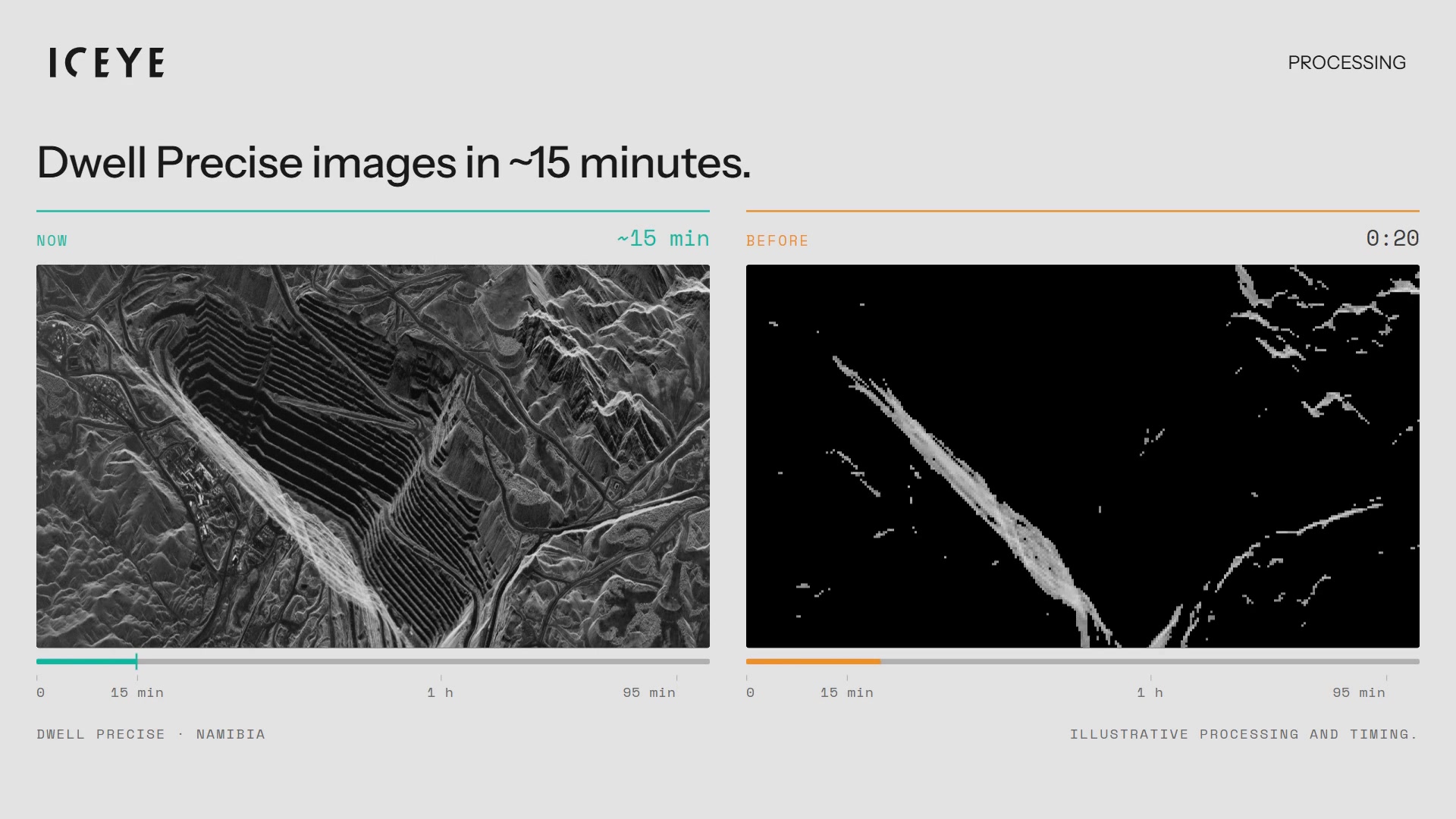
Figure 2. Highly complex Dwell Precise image modes can now be processed in approximately 15 minutes, a huge leap compared with the 95-minute processing times only a year ago. Processing and timing illustrative.
Most of this came from the polar format processor. When it was introduced, it cut processing times by roughly 70% across the Spot and Dwell modes, and further optimization has since halved them again. Our back projection processor has also been upgraded and now runs around 40% faster than its predecessor, and the wide-area processor is being rewritten for speed.
We are not done. We are rebuilding the core SAR libraries shared by all our processors in a modern high-performance language, giving us finer control over memory and data handling so that each optimization speeds up every processor at once. And we are focusing on the last step of the chain: product generation, which converts each focused image into customer data products. For our highest-resolution images, this step can take as long as image formation itself, which makes it the next big opportunity to deliver imagery faster.
One final piece of the processing puzzle happens before a satellite even acquires an image: deciding how long to illuminate the target. In SAR, azimuth (along-track) resolution is set not by time but by angle: how wide an arc the satellite sweeps across the target while collecting. How long that takes depends on geometry.
A target close to the satellite and directly to the side is swept through the required angle quickly. A target far off to the side, or far ahead of or behind the satellite (a high incidence or squint angle), moves through the satellite’s field of view much more slowly, so the same resolution needs a longer collection.
Historically, our Spot and Dwell modes used fixed imaging times, for example 15 seconds for Spot Fine and 25 seconds for Dwell. That made sense when most images were taken broadside in a narrow range of geometries. Our satellites now image much farther off-track and capture several squinted targets in a single pass, so one fixed duration no longer fits (Figure 3). In easy geometries, the satellite collects more data than it needs, increasing the amount of information that has to be downlinked and processed.
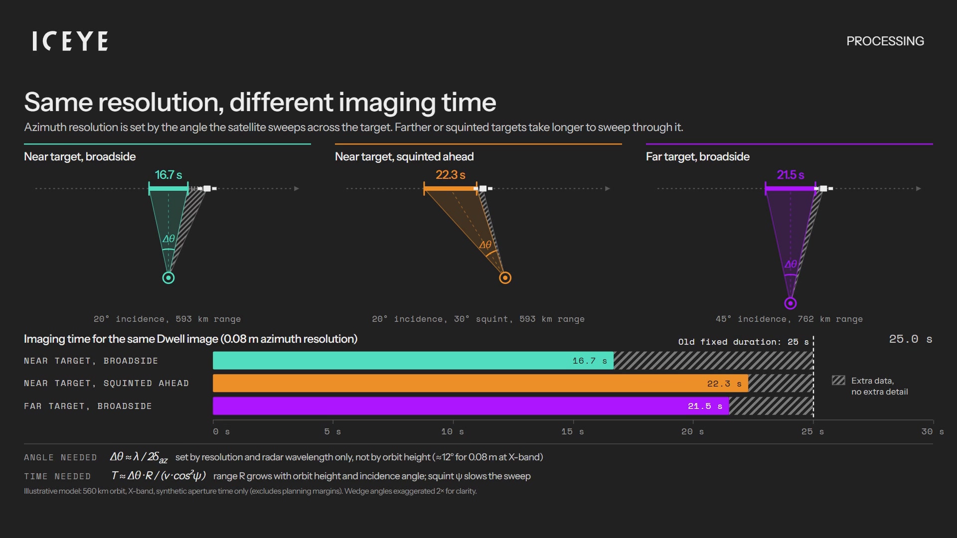
Figure 3. Imaging time examples for the same Dwell image for Dwell images of targets at different geometries. Azimuth resolution is set by the angle that the satellite sweeps across the target. Farther or squinted targets take longer to sweep through. Our planning software calculates imaging times for each target and chooses the shortest duration that will still meet the resolution requirement.
Since early 2026, our planning software has calculated the imaging time for every target individually. Based on the orbit and the exact incidence and squint angles, it chooses the shortest duration that will still meet the specified azimuth resolution: for example, 3.5 seconds, 8.7 seconds or 22.1 seconds.
The result is that satellites collect exactly the data that they need – no more, no less – reducing the volume of information flowing through the processing chain and helping to get insights to customers faster.
This is another example of why it pays to control the entire SAR pipeline. It allows us to approach the problem of latency in a more integrated way, making improvements at one stage of the chain that shorten processing times at another.
Reducing SAR processing latency is not about finding a single breakthrough algorithm or building faster computers. It is about identifying and removing unnecessary delays at every step, from the moment a collection is planned to the moment a product is delivered.
Sometimes that means doing the work faster: choosing the right algorithm for each acquisition, optimizing the software that runs it, and starting computation as soon as the data arrives. Sometimes it means avoiding unnecessary work by collecting only the data that is needed, validating that data intelligently, or eliminating dependencies on separate processing workflows. In every case, the goal is the same: deliver imagery that meets the customer's requirements as quickly as possible.
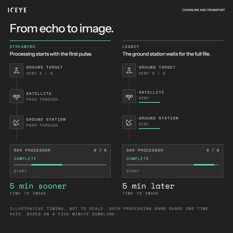
Once a SAR image has been collected by a satellite, it still has a long way to go. Ground-station availability, satellite geometry and throughput speeds all play a role in how quickly customers receive their imagery.
12 October 2026

07 October 2026

23 September 2026