Strategic-site_military_hero_medium

Summary: End-to-End SAR quality means effectiveness

In the context of synthetic-aperture radar (SAR) satellite imaging, high quality means end-to-end effectiveness. Getting a necessary answer to a strategic or tactical question, delivered in time to act on, in a form people and automated systems can use.

“We see where to aim, we understand what is best to strike with, and we have control over the consequences of strikes.”

Andrii Yusov

spokesperson, Ukraine’s Defence Intelligence, May 2026, United24Media

Elements of high quality SAR

Answers in time to act

What is high quality SAR imaging is not a matter of high resolution alone. It is a combination of several elements in a chain of end-to-end systems that must deliver accurate answers to specific operational questions in a reliable and timely manner. Below, examples of what high quality in end-to-end SAR means.

sar_satellite

Shorter wait for a satellite to reach an area

Mean time to access is the wait until a satellite can image a given location. At end of 2026, it is on average ~1 h 45 min at 45° latitude for ICEYE’s commercial fleet. An agile system enables more imaging with less passes: for example 45 high resolution images with just 3 consecutive passes, covering the Korean DMZ from west to east.

layers

Images on screen in minutes

Acquisition to delivery is the time from data being collected by a satellite to an image being available for an analyst can use. At the NATO Fighter Lion exercise in 2026, the fastest delivery from an ICEYE ISR Cell reached the analyst’s desk just under 13 minutes after acquisition, while further exercises have demonstrated 6 minute deliveries.

satellite_clouds

Targets that stand out

Signal-to-clutter describes how clearly an object is visible and separates from the surrounding land or sea. High performance radar imaging is the right tool for high stakes needs, such as making decoys detectable in a Danish demonstration in June 2026. “ICEYE showed that with SAR, targets can be distinguished day and night.” Maj. Gen. Jan Dam, Royal Danish Air Force and Space Force.

sar_image_library

The right level of detail for each task

Detecting vessels at sea requires covering lots of area at once instead of a high level of detail. Ensuring high reliability identification of detected objects requires high resolution and less area coverage. Information density combines resolution and signal quality into bits per square meter. ICEYE SAR satellites provide high information density imaging modes for every need.

operation

Enough capacity for the right opportunities

Geometric fit for operational analysis is used to describe whether a selected radar satellite imaging opportunity has physical line of sight to the intended imaging target from behind geographic and built structures. It is also used to describe if the processing chain places the imaging targets in alignment with earlier imagery for ease and speed for analysis. The world's largest SAR satellite fleet ensures necessary access opportunities, while ICEYE’s fleet-wide geolocation at 4.6 m CE90 in the slant plane ensures required accuracy.

data_processing

Data and analysis that people and automated systems can act on

Data exploitability is used to describe whether the delivered data products and derivatives fit the receiving end user systems, and whether automated systems and the people supporting decision making are trained for maximum effect. Ukraine has reported in March 2025 that over 40 percent of its ICEYE imagery at the time had been used to prepare strikes, highlighting a proven track record in operational use.
Operational uses

SAR is for operational uses where you simply must know

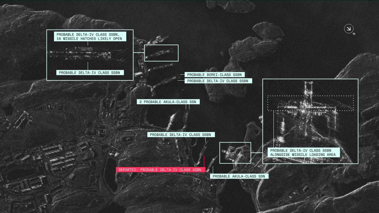
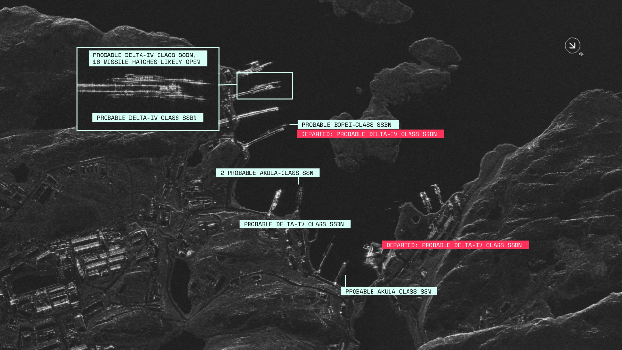
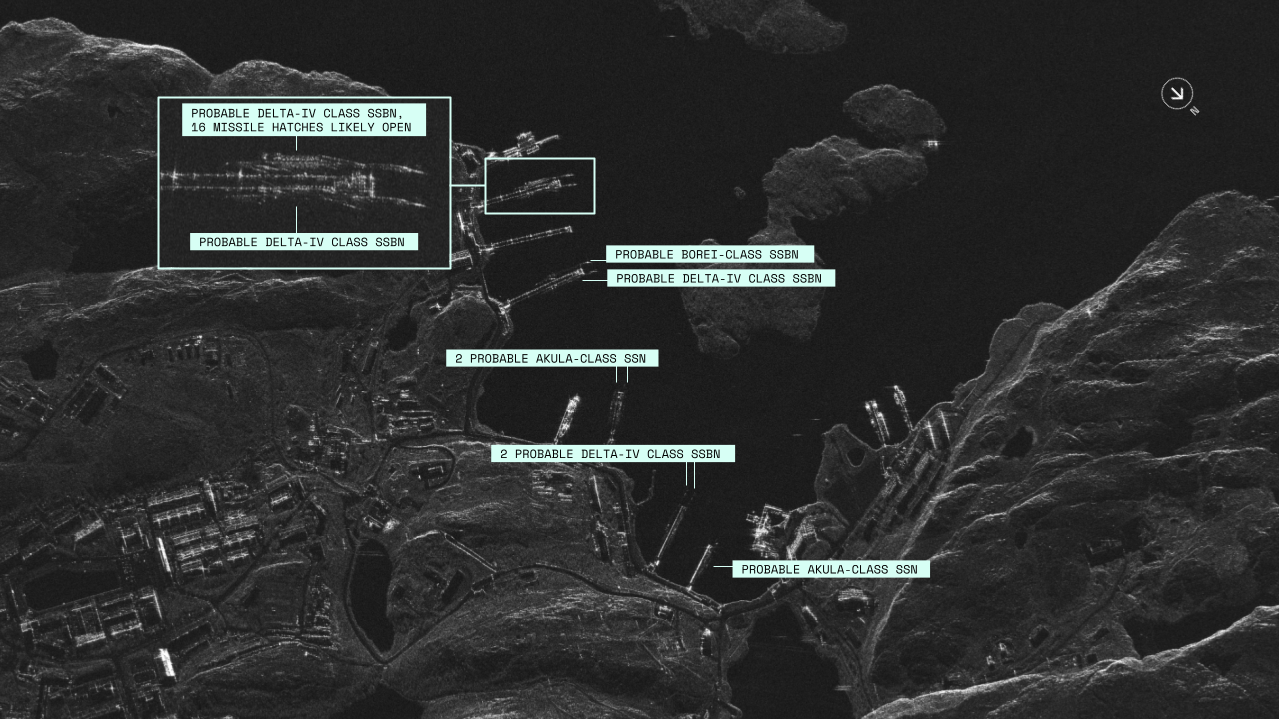
Understanding what is happening at a given location, both in strategic and tactical timescales, is dependent on end-to-end data that you can depend on. Below, a naval base monitoring image set demonstrates an operational use where timely, reliable end-to-end delivery is of utmost importance.

14 October 2025
17 October 2025
20 October 2025
Submarine base

GADZHIYEVO SUBMARINE BASE, RUSSIA

Submarine base

GADZHIYEVO SUBMARINE BASE, RUSSIA

Naval_base_3

GADZHIYEVO SUBMARINE BASE, RUSSIA

End-to-end SAR Quality

High quality SAR in practical terms

Radar imaging satellites can see through cloud, smoke and darkness, which gives them a unique edge for critical operational uses in security, natural catastrophe response, and more. For operational uses where systems have to be robust and perform 24/7 at high reliability, a high quality end-to-end system is required.

Four years of operational use in the defense of Ukraine

Ukraine’s Defence Intelligence (HUR) has used ICEYE SAR since September 2022. In the first five months it assessed almost 1,000 locations of Russian units and detected 7,321 units of military equipment (HUR, March 2023). 

"Thanks to ICEYE capabilities, a large part of this list has been destroyed and reflected in the daily reports of the General Staff of the Armed Forces of Ukraine."

Ukraine’s Defence Intelligence, March 2026


SAR image of the probable Rostov-on-Don submarine under a tarp in Sevastopol

In this previously published ICEYE Dwell Fine image, the probable Rostov-on-Don submarine is visible under a tarp in Sevastopol, occupied Crimea.

Relied for sovereign access by nations and NATO

Finland, Sweden, Poland, Germany, the Netherlands, Portugal and Greece have chosen ICEYE for sovereign SAR missions, and ICEYE supplies SAR data to NATO. Poland’s four-satellite system was handed over in under twelve months from contract. Serving officers have run and timed ICEYE’s ISR Cell in four exercises in 2025 and 2026.

“Integrating the space component into an exercise of the scale of the NATO Tiger Meet shows that using satellite data in operational environments is already a reality for the Air Force.”

General João Cartaxo Alves, Chief of Staff, Portuguese Air Force


ICEYE ISR Cell interior

The ICEYE ISR Cell is used to independently task satellites, collect and downlink imagery, process with AI-powered target recognition, and disseminating information to command.

SAR quality assessed by NASA, ESA and peer review

NASA’s Commercial Satellite Data Acquisition program published a radiometric and geometric quality assessment of ICEYE SAR products in January 2025, and ESA has published technical notes on ICEYE product quality. ICEYE’s daily-revisit radar also supplied part of the record for a NASA-funded, UC Irvine-led study in PNAS that mapped 30 years of Antarctic ice loss.

The first major success involving commercial synthetic aperture radar data providers for polar research”

UC Irvine, March 2026


Zoomed-in ICEYE Dwell Precise SAR image of Rotterdam, The Netherlands

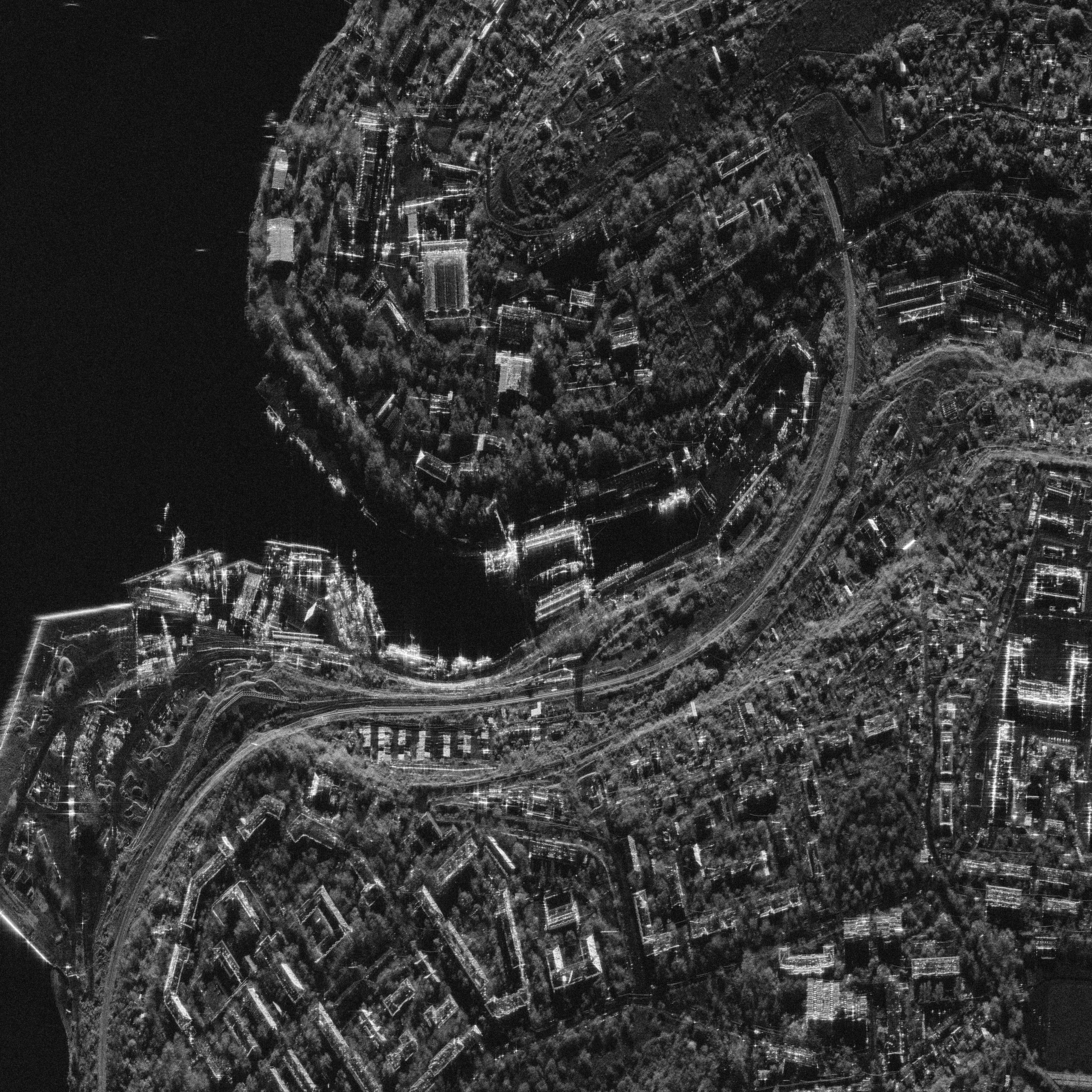
A portion of an ICEYE Dwell Precise mode image of Rotterdam, The Netherlands, as an example of the amount of detail available in an ICEYE SAR image.
Critical and timely answers for natural catastrophes

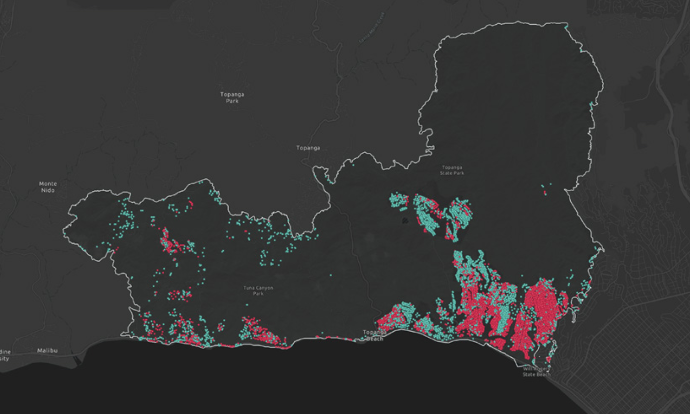
ICEYE delivers flood extent within 6 to 12 hours of a flood starting. After the January 2025 Los Angeles fires, its building-by-building damage calls were validated against CAL FIRE’s field assessment at 99 percent precision. During Hurricane Melissa, about 191,000 buildings with signs of damage were identified across Jamaica.

“We’ve never been able to push this data out to our international partners within a week of a hurricane before, until ICEYE and Esri.”

Alicia Edwards, National Spatial Data Management Branch, Jamaica


LA fires briefing thumbnail 2026

An example of ICEYE wildfire monitoring from 2026. ICEYE delivered high-resolution SAR wildfire insights within 24 hours of smoke detection across the Palisades and Eaton fire areas in Los Angeles.

“The benchmark of the space reconnaissance race is shifting from ‘how sharply can you see’ to ‘how widely, how often, and how fast can you see and decide.’”

K-Defense News, 8 September 2026

On ICEYE’s 45-image coverage of the Korean DMZ with 3 satellite passes

next steps

Want to know more?

Discover how high quality SAR systems and SAR data can empower your organization. Reach out to our experts today.