Contact us
Get in touch with our experts to find out the possibilities daily truth data holds for your organization.

Having originated from a university nanosatellite group, ICEYE has had learning at the heart of its mission since inception. We believe knowledge sharing is fundamental to humanity’s ability to adapt to the changing planet and the challenges those changes bring.

March 2026
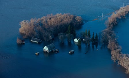
Download ICEYE's analysis on flooding from remnants of Typhoon Halong.

March 2026
Download ICEYE's analysis on the severe flooding and wind damage from Ex-Tropical Cyclone Alfred

November 2024
Download ICEYE's analysis on the severe flash flooding from the DANA Storm in November 2024.

Guide
Learn about satellite imaging technologies, applications, and benefits of SAR data
Learn how new technology from the private sector is changing the way government agencies respond to natural disasters at the community level.

Stay on top of growing customer expectations and respond rapidly to flood events with ICEYE’s globally consistent, high-resolution datasets

Learn more about ICEYE SAR satellite data for persistent monitoring, and specific imaging modes.
The product documentation describes ICEYE SAR product specifications, image ordering process, and related support information.

Discover how ICEYE SAR satellite data and Windward’s maritime AI enabled C4ADS to detect a likely ship-to-ship oil transfer under the cover of night.
Download our Application Study to learn how to use ICEYE SAR data to get actionable intelligence on port operations, anywhere in the world.
Download our Application Study to learn how to use ICEYE SAR data to obtain actionable insights on unusual concentration of aircraft, vehicles and equipment in any strategic site on the globe.

Insurance Times x ICEYE webinar
Listen to industry experts from Insurance Times, Aviva, Zurich, and ICEYE as they explore how UK insurers can anticipate risk before the waters rise, streamline claims when disaster strikes, and support customers more effectively through the full flood lifecycle.

Government & Utilities webinar
In this webinar, experts from ICEYE, the global leader in persistent monitoring with Synthetic Aperture Radar (SAR) satellite technology, will demonstrate how satellite data is transforming the way European government agencies prepare for, respond to, and recover from severe flooding events.

EigenRisk x ICEYE webinar
Learn how observed wind and flood damage data from ICEYE, integrated into the EigenPrism platform, helps insurers and risk managers respond faster and more effectively to hurricane impacts.

Government & utilities webinar
In a recent webinar, experts discussed the integration of ICEYE’s satellite technology for real-time flood monitoring and emergency response.

Commercial Risk x ICEYE webinar
In this webinar, the panel of experts explored which areas are most at risk from secondary perils, whether risk managers and the insurance industry can adequately model these risks, and what type of insurance solutions are available.
Government & Utilities webinar
Join ICEYE’s Head of Government Solutions of North America, Mike Bennett, to learn how you can optimize your disaster response and recovery efforts using synthetic aperture radar (SAR) data from a real-life use case scenario during Hurricane Helene.

Case Study
How ICEYE Flood Insights supported situational awareness and post-event validation during Ex-Tropical CycloneAlfred in February 2025.
Case study
Find out how the flood insights provided by ICEYE in collaboration with New Light Technologies and other contractors made a difference in response and recovery activities during the 2022 Atlantic hurricane season.
Case study
Find out how one of Japan's leading insurance companies improved its claims management process for major flood events.
Case study
Find out how Suncorp's game-changing partnership with Arturo and ICEYE accelerated customer support during major floods in Australia.
The Swath Acquisition Viewer is application that ICEYE employs for quickly identifying potential acquisition opportunities over any area of interest with the ICEYE satellites and sensor, speeding up the efforts in data ordering for your needs.


May 13, 2026
7 min read
How to unlock resilience for emergency response in Australia
Read more How to unlock resilience for emergency response in Australia →

