Wildfire_suburban-house_hero_medium Wildfire_suburban-house_hero_medium_mobile

ICEYE Wildfire Insights

Assess wildfire damage before the smoke has cleared

Your satellite-based solution for building-level damage data for wildfire events.

What if you could understand wildfire damage within hours, not days?

As the weather becomes more extreme due to climate change, communities around the world are being affected by larger, more severe, and more frequent wildfires. ICEYE's Wildfire Insights helps by providing a near real-time assessment of building damage within the fire perimeter.

Stephen-vid-thumbnail-2 Large

Rapid building-level wildfire damage assessment for insurers

Stephen Lathrope & Shay Strong / ICEYE

Insight-led decisions for P&C insurers

security_icon

Allocate your field resources smarter

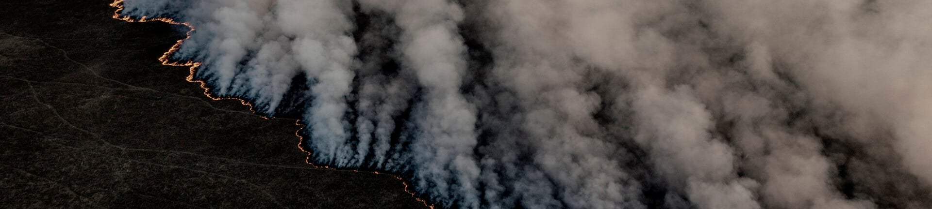
ICEYE enhances your ability to swiftly and effectively respond to fire events, helping to optimize your resources and improve the quality of service offered to affected communities.

document_search

Size losses better

We provide near real-time building damage assessment for wildfire and bushfire events, empowering you to calculate losses, manage risks, and carry out disaster response efforts more effectively.

fast_icon

Accelerate claims

Our technology helps make informed decisions, such as how many people to dedicate to respond to incoming claims/client outreach, or how much capital you need to reserve to take out to pay out incurred but not reported future claims.

Wildfire-render-satellite_hero_small

Rapid building-level damage detection with smoke-penetrating satellites

Stay ahead of wildfire damage with building-level damage data

Until now, when aerial optical imagery was available for a wildfire event, insurers often had to scan through images and annotate them by themselves to determine if their individual properties were impacted.

ICEYE Wildfire Insights provides near real-time situational awareness to insurers before optical imagery can be captured, so you can base your decisions on rapid and verifiable observation data.

Fire_data_Oregon_onethird

Building-level damage assessment

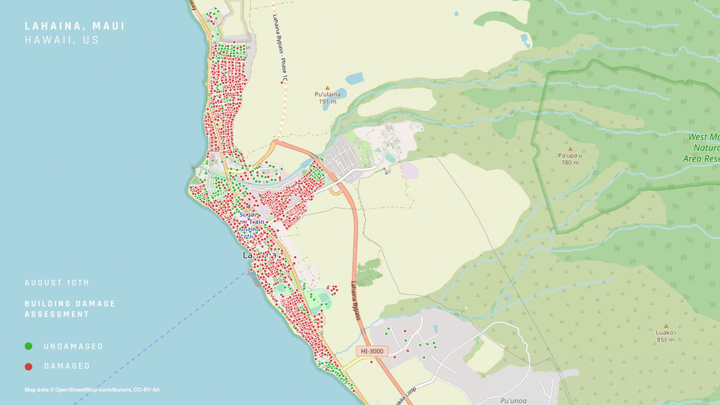
ICEYE's building damage assessment product delivers the output in a vector format (either latitude, longitude points or building footprints) with a binary classification of structural damage (‘destroyed’/’undamaged’) per location within 24 hours.

ESRI_wildfire_onethird@1x

Wildfire monitoring application via Esri

We also offer an Esri-based wildfire monitoring application to display active wildfires, utilizing a set of data sources, including fire perimeters/fire locations, hotspots, building footprints and populated urban centers.

before-after-web-after before-after-web-before

Wildfire damage in Lahaina, Maui in Hawaii.

Partner Webinar

Introducing ICEYE Wildfire insights with advance monitoring and damage assessment

See through the smoke with revolutionary satellite technology, day and night

ICEYE’s large constellation of Synthetic Aperture Radar (SAR) satellites provides access to an entirely new level of persistent monitoring for any location on Earth - uninterrupted visibility, day and night, in any weather conditions. This globally available, actionable intelligence is taking the P&C insurance industry through a step-change transformation.

globe_satellite

Real-time monitoring

Owning the world’s largest Synthetic Aperture Radar (SAR) constellation, ICEYE combines earth observation insights from space with advanced data analytics and machine learning.

satellite_clouds

All-weather capabilities

By leveraging our SAR technology, you can acquire data regardless of weather, light, and smoke conditions in any given area.

fast_icon

Rapid data delivery

We deliver actionable data every 24 hours during impactful wildfire catastrophes in the US.

document_search

Reliable insights

As a result, our customers obtain accurate and immediate, building-level insights into the situation on the ground.

Wildfire_smoke-cloud_hero_small

See why top-tier insurers trust ICEYE for immediate event response, loss sizing, and loss adjustments.

Other perils

Product

Flood Insights

Immediately understand the impact of floods and base your decisions on reliable, near real-time flood extent and depth data.

Flooding_Suburban-houses_onethird

Beta

Wind monitoring

Gain access to situational awareness and near real-time damage data related to storms that occur across the globe.

Hurricane-satelllite-render_onethird

Beta

Earthquake monitoring

Embrace a proactive approach with ICEYE’s actionable insights before, during, and after an earthquake.

Earthquake_Turkey_onethird

Stay in the know

Sign up for our Insurance solutions newsletter for regular updates about ICEYE products and get exclusive insights on the most pressing natural catastrophes delivered to your inbox.

Learn more about how we can support your organization