FLOODING FROM HURRICANE IDALIA, US, AUGUST 2023
POWERED BY MULTISOURCE DATA ANALYSIS LEVERAGING ICEYE SATELLITE IMAGERY
ONGOING ANALYSIS


880.26 SQ MI
(2280 KM2)
total flood extent

0.76 FT (0.2 M)
average depth at building level
Disclaimer: The impact numbers are subject to change as ICEYE continues to analyze the flood and extend the analysis area. Some areas which have been impacted by the flooding may not be represented in this initial data.
Live updates
ICEYE'S FINAL DATA RELEASE; Flood Briefing is available
September 7, 2023
The conclusive analysis for this event, the fifth and final release, has been completed and delivered to our customers. If you are interested in accessing a part of it, download our flood briefing using the link below.
we increased the overall extent of the analysis with release 4
September 6, 2023
Yesterday, we delivered the 4th release (R4) of ICEYE's analysis, which included new and updated flood extent and depth data along the Western Coast of Florida and Eastern Georgia, South Carolina, and North Carolina. Our 5th release (R5) is currently underway, and we aim to deliver it to our customers by the end of the day.
Based on R4, the current flood extent in Florida is 502.89 sq mi, with an average building-level depth of 0.64 ft. The extent for GA, SC, NC is 377.48 sq mi, and the average depth at building level is 0.87 ft.
See 2 impacted areas from our R4 analysis we haven't shared before: Treasure Island, Florida, and Ocean Isle Beach, North Carolina.
Before-and-during the flood at Treasure Island, Florida.
Before-and-during the flood at the Ocean Isle Beach, North Carolina.
ANALYSIS HAS BEEN UPDATED; MORE INFO ON FL, GA, SC, NC
September 4, 2023
Over the weekend, our team produced and delivered the 2nd and 3rd releases of our flood extent and depth analysis. The updated release contains more information on the impacted areas in Florida, including Steinhatchee, Crystal River, and Homosassa, as well as in Georgia, South Carolina, and North Carolina. Based on our 3rd release, delivered on September 2nd, the total number of affected buildings in FL, GA, SC, and NC is 13,811, with over 440 of them being inundated by more than 5 feet of water.
Before-and-during the flood at Steinhatchee, Florida, US.
Before-and-during the flood at Suwanee, Florida, US.
Our team is working on the 4th analysis release, with an aim to deliver it to our customers within the next 24 hours. Talk to our team to get the full analysis.
SECOND RELEASE UNDER WAY
September 1, 2023
We are working on the second analysis release, which will include new areas along the East Coast of the United States and into Charleston and Myrtle Beach, South Carolina as well as Oak Island & and Jacksonville areas, North Carolina. We aim to deliver it to our customers within the next few hours.
OUR FIRST ANALYSIS RELEASE ON HURRICANE IDALIA IS Available
August 31, 2023
Hurricane Idalia has weakened to a tropical storm over North Carolina, with heavy rainfall expected to persist for another 12 hours. The storm is set to move offshore by midnight UTC. Reports indicate 4-7 inches of rain across Idalia's path, with significant coastal flooding on the east coast in the last 24 hours.
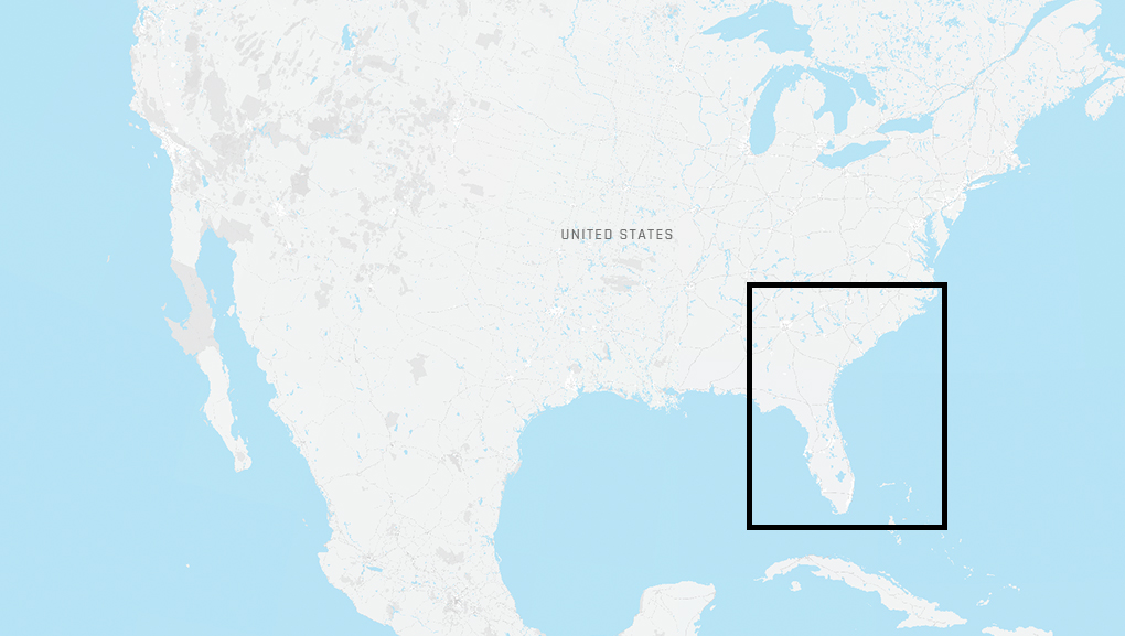
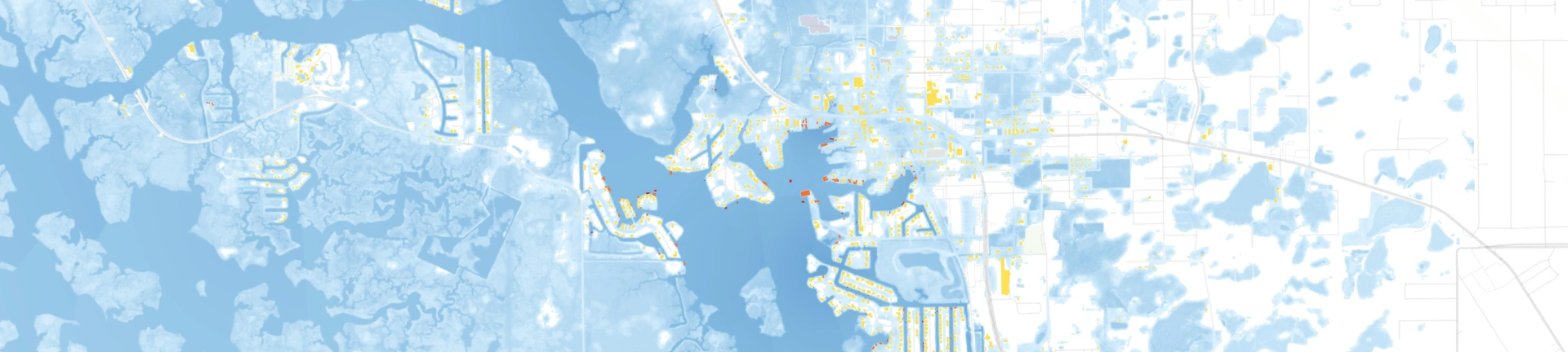
Our flood extent and depth analysis is ongoing, with completion aimed at 12:00 UTC today. The first version of our building-level data delivery will be sent to our customers shortly after that, focusing on the below areas across Florida's west coast.
Initial data from South Carolina is now coming in, with more anticipated soon.
HURRICANE IDALIA MADE LANDFALL IN FLORIDA
August 30, 2023
Hurricane Idalia has made landfall in Florida. We've already observed its initial impacts on the coastal areas and continue monitoring the area with our cloud-penetrating SAR satellites. We expect to deliver our 1st flood extent & depth analysis in 24-48 hours.
HURRICANE IDALIA is ABOUT TO MAKE LANDFALL tomorrow
August 29, 2023
Major Hurricane Idalia has made landfall in Florida. We've already observed its initial impacts on the coastal areas and continue monitoring the area with our cloud-penetrating SAR satellites. We expect to deliver our 1st flood extent & depth analysis in 24-48 hours.
As it looks now, storm surge impacts are anticipated to be severe (up to 12ft) in the Tampa Bay and Big Bend regions.
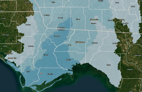
This graphic illustrates our anticipation for impacted watersheds from rainfall flooding in the panhandle, the darker blue is indicative of more severe flooding. We are anticipating both riverine and street (flash flood style) flooding as a result of this event.
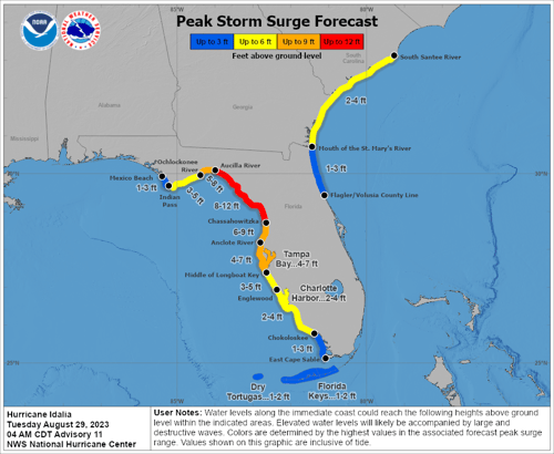
This is the National Hurricane Center's (NHC) storm surge forecast, valid from 4 a.m. CDT, August 29. As always, forecasts are updated rapidly in the final hours before a Hurricane, so this expectation is subject to change.
We've started the event monitoring utilizing the capabilities of SAR satellite constellation and our auxiliary data sources.
HURRICANE IDALIA is APPROACHING FLORIDA'S BIG BEND REGION
August 29, 2023
As Hurricane Idalia is expected to make landfall in Florida's Big Bend region tomorrow, state-level preparations are ongoing. A life-threatening storm surge is expected along much of Florida's west coast, and heavy rain will spread inland across several states.
Our monitoring is ongoing, make sure to revisit this page for more updates.
FLOOD EARLY WARNING ALERT IN FLORIDA
August 28, 2023
During the weekend, a tropical storm formed in the Gulf of Mexico and continues to develop as it moves northwards. There's a high risk for hurricane-strength impacts on Florida & and other states in the Southeast USA by late Tuesday.
Our Flood Monitoring team is closely watching this event.
LATEST FLOOD BRIEFINGS
Explore our collection of near real-time flood mapping and analysis from across the globe.

Flooding from Hurricane Idalia in Southeast US
View ICEYE's flood briefing on the flooding from Hurricane Idalia in Southeast US from September 2023.

Flooding in Northeast US
View ICEYE's flood briefing on the flooding in Northeast US from July 2023.

Flood Briefing: California, US
View ICEYE's flood briefing after atmospheric river hit in California, US
STAY IN THE KNOW
Our clients have access to near real-time hazard and damage data to accurately and quickly respond to natural disasters, improve their decision-making, and ultimately transform their customer experience.
Contact us Subscribe to natcat insights