Contact us
Get in touch with our experts to find out the possibilities daily truth data holds for your organization.
Persistent Monitoring
Natural catastrophe solutions
Press release
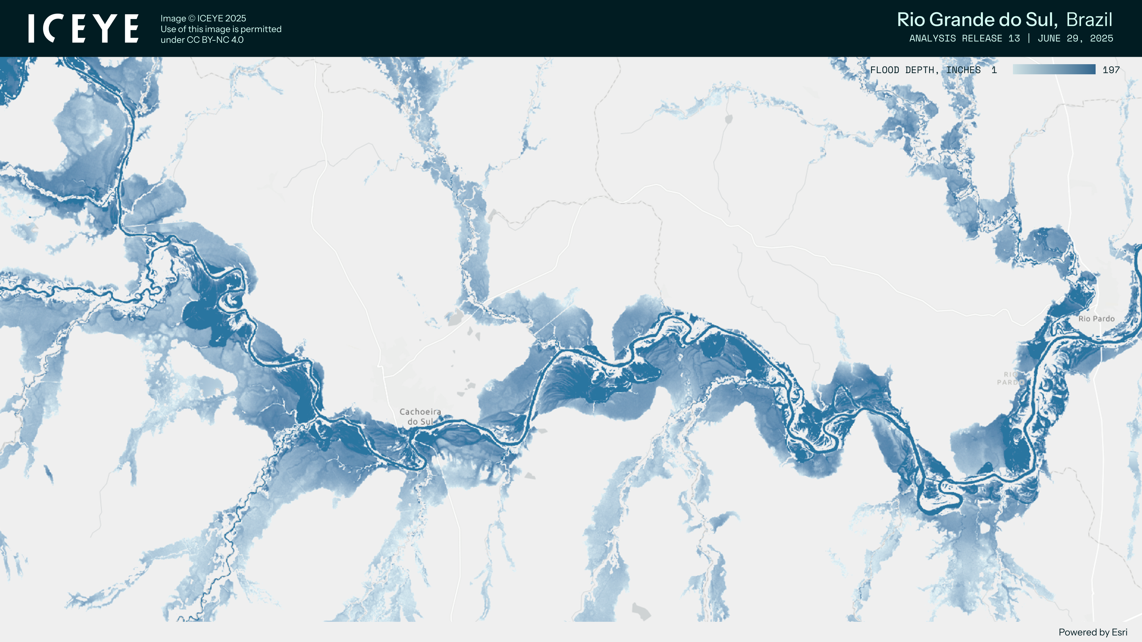
Porto Alegre - July 10, 2025 - ICEYE, the global leader in Synthetic Aperture Radar (SAR) satellite monitoring technology, has played a crucial role in supporting the government of Rio Grande do Sul in its rapid response to the devastating floods that struck the state in June.
Beyond providing high-precision SAR imagery captured even under heavy cloud cover, ICEYE delivered its Flood Solutions, a comprehensive service that combines near real-time flood observations with advanced intelligence analysis of SAR data and other geospatial sources. This enabled accurate and timely mapping of flood extent and depth across the affected areas.
Thanks to these actionable insights, the government was able to swiftly activate emergency protocols and ensure that aid from the Volta por Cima program reached vulnerable families without delay. The effectiveness of the response highlights the transformative impact of ICEYE Flood Solutions in disaster management and humanitarian relief.
In this new phase of the program, R$4 million is being allocated to support approximately 2,000 families impacted by the June storms. The funds are being disbursed immediately and without the need for prior registration. The process was completed in less than a week thanks to the integration of state databases with ICEYE’s advanced geospatial intelligence.
The State Secretariats of Planning, Governance, and Management (SPGG) and of Social Development (SEDES) are leading this initiative through the coordination of the MUP – Mapa Único do Plano Rio Grande, a platform that ensures traceability, transparency, and agility in the allocation of public funds.
“The use of ICEYE data has been crucial in accurately identifying the hardest-hit areas, even in scenarios with cloud coverage — a common challenge during extreme weather events,” said Danielle Calazans, Secretary of Planning, Governance and Management of Rio Grande do Sul. “Thanks to our collaboration and response time, the State had the ability to react quickly and provide financial credits through the social cards, precisely to the families currently being affected.”
The adoption of this technology in southern Brazil stems from a technical mission conducted by SPGG to Finland, where state officials were welcomed by ICEYE executives to explore solutions for dealing with increasingly frequent and severe climate disasters.
In May 2024, ICEYE played a pivotal role in responding to another major flood event in Rio Grande do Sul by deploying its satellite constellation to map affected areas with precision. The company directly supported rescue, mitigation, and reconstruction efforts.
Thanks to its unique ability to capture images regardless of weather or lighting conditions — even at night or under cloud cover — ICEYE Solutions provided high-resolution geospatial data to public authorities, civil defense teams, humanitarian organizations, and private companies.
This data gave public and private decision-makers a comprehensive view of the situation, helping identify critical zones, damaged infrastructure, flooded areas, and optimal shelter locations. Additionally, the data now serves as a historical record of the floods’ progression, supporting both immediate response and long-term disaster prevention planning.
“Our mission is to provide timely and actionable geospatial intelligence that enables governments and organizations to respond swiftly and effectively in moments of crisis. In the case of Rio Grande do Sul, our Flood analysis was instrumental in accurately mapping the full extent of the flooding. This critical insight supported the rapid deployment of resources in record time within just one week,” said Ariadna Gutierrez, Senior Manager, Latin America Government Solutions at ICEYE.
ICEYE delivers unparalleled persistent monitoring capabilities to detect and respond to changes in any location on Earth, faster and more accurately than ever before.
Owning the world's largest synthetic aperture radar (SAR) satellite constellation, ICEYE provides objective, near real-time insights, ensuring that customers have unmatched access to actionable data, day or night, even in challenging environmental conditions. As a trusted partner to governments and commercial industries, ICEYE delivers intelligence in sectors such as defense and intelligence, insurance, natural catastrophe response and recovery, security, maritime monitoring, and finance, enabling decision-making that contributes to community resilience and sustainable development.
ICEYE operates internationally with offices in Finland, Poland, Spain, the UK, Australia, Japan, UAE, Greece, and the US. We have more than 700 employees, inspired by the shared vision of improving life on Earth by becoming the global source of truth in Earth Observation.
Media contact
press@iceye.com
Other assets available at https://www.iceye.com/media-assets
Get the latest news and updates from ICEYE directly to your email. Don't forget to follow us on @iceyefi & on LinkedIn. For press inquiries and further materials please refer to our Press section.
