Contact us
Get in touch with our experts to find out the possibilities daily truth data holds for your organization.
Helsinki, FINLAND – January 22 – ICEYE, the leader in synthetic-aperture radar (SAR) technology for microsatellites, and Spire Global Inc, the world’s largest space-to-cloud analytics company, announced today a new collaborative technology to enable the detection of dark vessels and illegal activities at sea. This new service offering will give both ICEYE and Spire’s users a completely new satellite capability to assist in the detection and elimination of illegal fishing. The new product will assist in the detection of illegal transshipment and enable countries with a never before available level of visibility and awareness of vessels within exclusive economic zones. This new solution will also greatly reduce security threats and provide the industry a new way to monitor maritime trafficking.
VISUALIZATION:
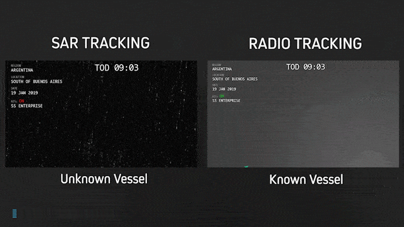
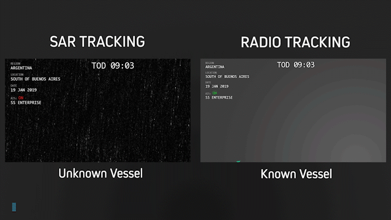
Detecting dark vessels that do not have their required AIS tracking turned on.
---
In addition to detecting dark vessels, this technology partnership will allow users a new level of accuracy in tracking vessels involved in trafficking of everything from arms, drugs, commodities, and people that want to avoid being seen. With the economic value of illegal fishing estimated to be up to 23B USD annually, this solution was developed to directly address this combination of economic, environmental, human rights, and industry-wide security issues.
“We are constantly seeking partnerships that complete ICEYE’s near real-time satellite monitoring capability and help us create new services for our customers. To that end, we’re thrilled to work with Spire as it has become an industry leader with its approach in the development of its nanosatellite constellation,” said Pekka Laurila, CSO, and Co-Founder, ICEYE. “This alliance will provide more businesses and governments with a new and increased ability to monitor maritime traffic, including vessels that want to avoid detection.”
The service will tap into Spire’s Satellite AIS (Automatic Identification System), which is currently used for continuous monitoring of vessels around the globe, in tandem with ICEYE’s satellite-based synthetic aperture radar imaging, which was designed to see dark vessels when they don’t report on their activity. Spire will utilize ICEYE’s unique ability to provide reliable, high revisit rates for radar satellite imaging, multiple times each day from anywhere on Earth, with imaging that functions through clouds at any time of day. This will allow both Spire and ICEYE to produce and provide a new data set of more substantial information at revisit rates never before possible.
EXAMPLE CASE:
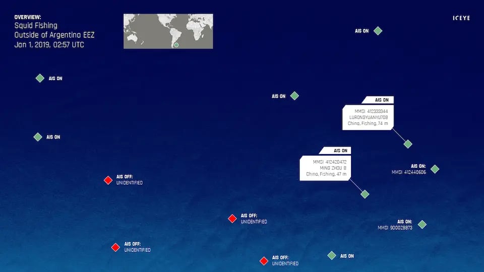
Squid fishing near the Exclusive Economic Zone (EEZ) of Argentina.
In the colored ICEYE-X2 SAR image above, there are Chinese squid fishing vessels that have their AIS tracking turned on, while other vessels have their AIS off. Without AIS, detected vessels remain unidentified.
Argentina has been suffering from an increase in illegal squid fishing within its EEZ - the squid stocks are depleting and the available catch are decreasing in size. There have been incidents where the Argentine Coast Guard has had to take reactive actions against illegal vessels. This new dark vessel monitoring service from ICEYE and Spire brings systematic monitoring for cases such as this.
---
“Data fusion holds an enormous potential impact for our world. By combining data sets like AIS and SAR, we gain previously unrealized insights in the movement of goods and people around the globe. Our relationship with ICEYE means that never before available tools will suddenly be an actionable resource to those committed to securing our oceans.” said John Lusk, General Manager, Spire Maritime.
Spire has become an industry standard for data collection in the commercial aerospace sector and operates one of the largest constellations of private nanosatellites and ground station networks in the world. The company has also launched strategic partnerships across a myriad of verticals including deals with NASA, ESA and key players in the weather, maritime and aviation sectors.
ICEYE successfully launched its second SAR satellite, ICEYE-X2, on 3rd of December, 2018. The satellite launch is an initial step to creating the necessary SAR satellite constellation of ICEYE for frequent and reliable satellite-based information about any location on Earth. ICEYE is establishing the Internet of Locations to support vast economic growth in Finland in the various parts of generating, analyzing and consuming satellite data for operational uses.
WEBINAR Feb 12th, 2019:
Fusing AIS Data and SAR to enable global monitoring of dark vessels
Join us on February 12th, 2019 at 8:00 am PST (11:00 am EST, 5:00 pm CET) for an ICEYE + Spire webinar “Fusing AIS Data and SAR to enable global monitoring of dark vessels,” to learn about the ICEYE + Spire collaboration and how it is enabling the detection of dark vessels and illegal activities out at sea. Spire's Satellite AIS is used for continuous monitoring of vessels around the globe. ICEYE's radar satellite imaging is used for seeing dark vessels when they don’t report on their activity.
To learn more, visit: https://attendee.gotowebinar.com/register/4259438073338611971
# # # # #
About ICEYE
ICEYE empowers others to make better decisions in governmental and commercial industries by providing access to timely and reliable satellite imagery. The company is tackling this crucial lack of actionable information with world-first aerospace capabilities and a New Space approach. ICEYE’s radar satellite imaging service, with coverage of selected areas every few hours, both day and night, helps clients resolve challenges in sectors such as maritime, disaster management, insurance, finance, security and intelligence. ICEYE is the first organization in the world to successfully launch synthetic-aperture radar (SAR) satellites with a launch mass under 100 kg. For more information, please visit: www.iceye.com
About Spire Global Inc.
Spire Global Inc. is a space to cloud analytics company that utilizes proprietary satellite data and algorithms to provide the most advanced maritime, aviation, and weather tracking in the world. Spire’s data analytics is backed by a wholly owned and developed constellation of nanosatellites, global ground station network, and 24/7 operations that provide real-time global coverage of every point on Earth. To learn more, visit: www.spire.com
Other assets available at https://www.iceye.com/press.
Download images by right-clicking and selecting "save link as":
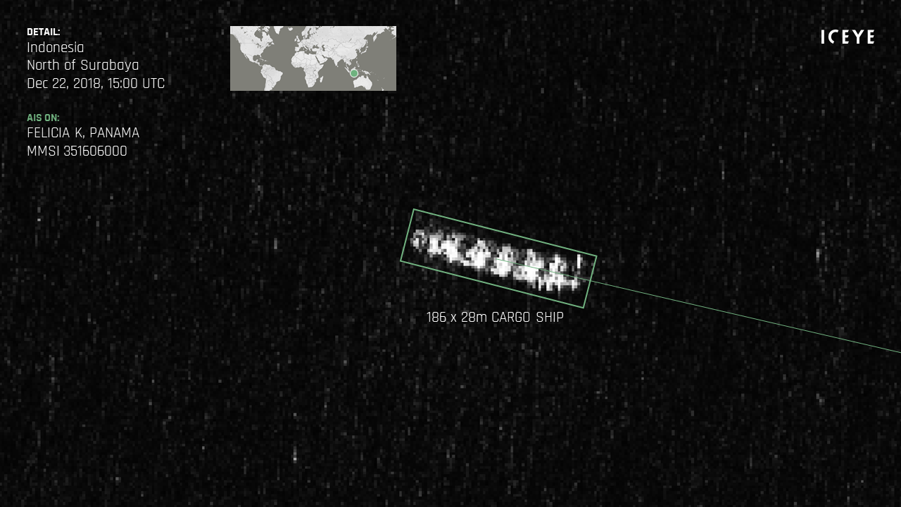
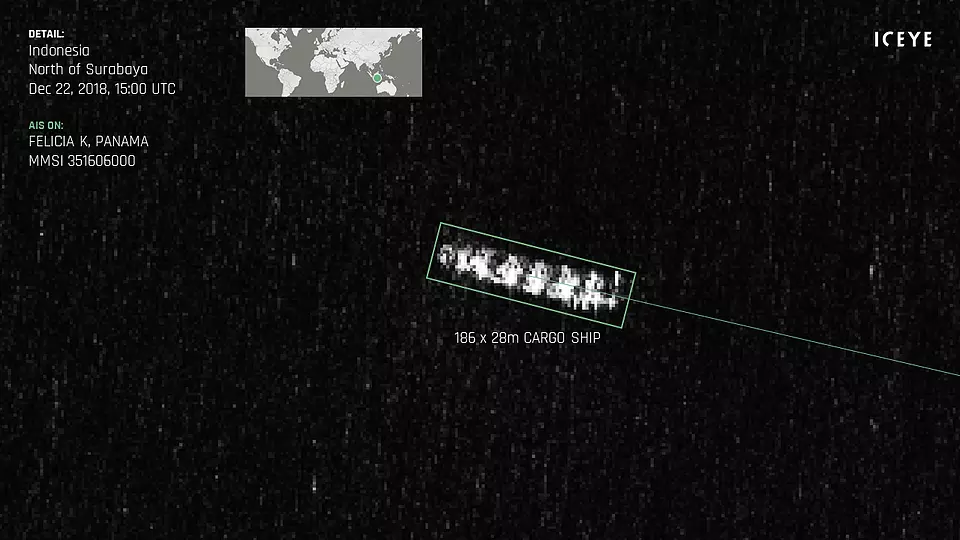
"An identified cargo ship North of Surabaya, Indonesia on December 22, 2018, 15:00 UTC."
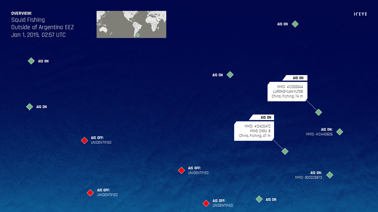
"Squid fishing outside of Argentina Exclusive Economic Zone (EEZ) on January 1, 2019, 02:57 UTC."
"SAR + AIS data fusion from ICEYE and Spire."
![]()
ICEYE logo.
![]()
Spire logo.