Contact us
Get in touch with our experts to find out the possibilities daily truth data holds for your organization.
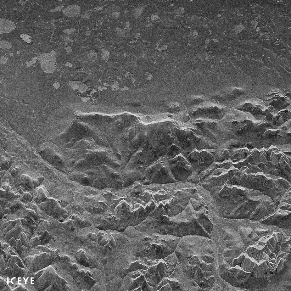
Helsinki, FINLAND – January 17, 2018 – ICEYE, the leader in synthetic-aperture radar (SAR) technology for microsatellites providing expanded access to reliable and timely earth observation data, today published the first radar image obtained with the ICEYE-X1 SAR satellite. The image depicts Noatak National Preserve, Alaska, on Monday Jan. 15, at 21:47 UTC. ICEYE-X1 is the world’s first SAR satellite under 100 kg, launched less than a week ago on Jan. 12, 2018 on ISRO’s PSLV-C40 from Satish Dhawan Space Center in India.
A synthetic-aperture radar (SAR) instrument sends its own radio waves to the ground, creating an image from the energy that scatters back to the instrument. Given this, SAR sensors can provide imaging of the Earth during both day and night, regardless of cloud cover and weather condition. Conventional SAR satellites typically weigh in excess of 1000 kg due to the amount of instrumentation on board. ICEYE-X1 is ICEYE’s first satellite mission. Both the satellite bus and the SAR instrument were developed and integrated by ICEYE. ICEYE-X1 is a significant shift in size from traditional SAR satellites, allowing the technology to be condensed into a satellite weighing under 100 kg. This in turn enables launching a constellation of many satellites rather than only a few.
Click for image - ICEYE-X1, Noatak National Preserve, Alaska
In the image, North is roughly to the right.
The full image transmitted to the ground from ICEYE-X1 exceeded 1.2GB of raw data and spans an area of roughly 80 x 40 km on the ground. ICEYE-X1 obtained the image in the span of ten seconds, traveling at a speed of more than 7.5 km/s and at an altitude exceeding 500 km. Matching what ICEYE simulated prior to the launch, the final data resolution from the first satellite reaches 10 x 10 meters.
“With this single image, the ICEYE-X1 mission is already a full success regarding our most important goals, but this is just the beginning,” said Rafal Modrzewski, CEO and co-founder of ICEYE. “We are now working to increase the range of incidence angles and to more than double the ground resolution for ICEYE-X2. We are looking forward to launching our next mission as soon as this summer.”
ICEYE-X1 has been successfully communicating with the ground since 05:20 UTC, Jan. 12th, using both S-band and X-band for transmission. Telemetry data exchanged with the satellite in the first 100 orbits has already reached more than 1GB, surpassing a critical milestone for the mission.
“We are moving towards the calibration of our SAR instrument and increasing image quality in orbit. The mission is progressing with a timeline faster than all expectations,” said Pekka Laurila, CFO and co-founder of ICEYE. “After our initial SAR instrument calibration is finished, we will start operational pilot imaging services for our first customers.”
# # # # #
About ICEYE
ICEYE aims to provide democratized access to reliable earth observation data through developing efficient SAR sensors and microsatellites, enabling everyone to make better decisions. Through an imaging service available anywhere around the globe, anytime, and with revisit times measured in just few hours, ICEYE helps clients resolve challenges in segments such as maritime, disaster management and security and intelligence. ICEYE is the first organization in the world to launch SAR microsatellites and expects to commence its commercial data operations in the first half of 2018. ICEYE has received funding from the European Union’s Horizon 2020 research and innovation programme via the SME Instrument. For more information, please visit: www.iceye.com
Other assets available at https://www.iceye.com/press .
Download images by clicking:
"The published ICEYE-X1 image depicts Noatak National Preserve, Alaska, on Monday Jan. 15, at 21:47 UTC."
Link to location on Google Maps (in similar orientation to the image):
https://www.google.com/maps/@67.4292709,-162.3409447,55919a,35y,270h/data=!3m1!1e3
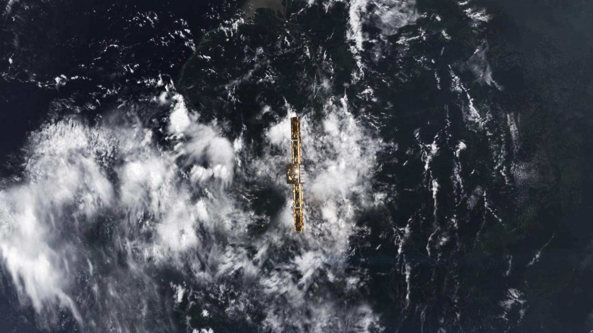
"ICEYE-X1 SAR satellite in orbit."
![]()
ICEYE-X1 Mission Logo.
![]()
ICEYE logo.