Contact us
Get in touch with our experts to find out the possibilities daily truth data holds for your organization.

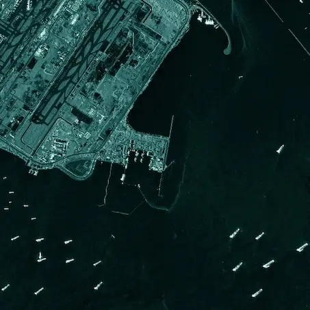
ICEYE US delivers reliable and innovative remote sensing capabilities to the United States Government, its allies and commercial partners using SAR technology.

Eric Jensen - CEO of ICEYE US

Government
Our near real-time insights empower proactive responses to natural catastrophes, enhancing your preparedness and resilience.

Insurance
Gain immediate clarity on the impacts of natural catastrophes with ICEYE's accurate, near real-time insights and solutions for the insurance sector. Enhance your ability to assess and respond promptly, ensuring superior customer service and effective risk management.

April 5, 2023
2 min read
ICEYE US Awarded a Multi-Year Blanket Purchase Agreement by NASA to Provide Radar Satellite Imagery for Evaluation in Support of Earth Science and Research
Irvine, California, US – April 5, 2023 – ICEYE US Inc., a subsidiary of ICEYE, the global leader in persistent Earth monitoring with radar ...
Read the post ICEYE US Awarded a Multi-Year Blanket Purchase Agreement by NASA to Provide Radar Satellite Imagery for Evaluation in Support of Earth Science and Research →
January 20, 2022
3 min read
ICEYE US Wins Contract to Participate in National Reconnaissance Office’s Broad Agency Announcement for Commercial Radar
Irvine, CALIFORNIA – January 20, 2022 – ICEYE US, a subsidiary of ICEYE, the global leader in persistent Earth monitoring with radar ...
Read the post ICEYE US Wins Contract to Participate in National Reconnaissance Office’s Broad Agency Announcement for Commercial Radar →
November 18, 2021
3 min read
ICEYE and U.S. Army to Pursue Collaborative Research and Development
Irvine, CALIFORNIA – November 18, 2021 – ICEYE, the global leader in persistent monitoring with radar satellite imaging, announced today ...
Read the post ICEYE and U.S. Army to Pursue Collaborative Research and Development →